3 Collins Street, Addington
32 reports on record since March 2019 · 23 with photographs. The most-reported address on Collins Street. Indicative rating valuation and school zones, hazards, bin day and what stood here before.
What gets reported here
Photographed here 23 on record


Reported here
 Graffiti on a traffic light pole or cabinet, or wa —
 Traffic control cabinet
 Overgrown Vegetation —
 Can’t see oncoming traffic when turning left onto Brougham St from Collins Street because of the overgrown bushes
 Poles and Signage - General —
 Cyclist lane button not triggering lights heading south at Brougham/Collins pedestrian crossing.
 Dumped Rubbish —
 Someone has put their bins out with rubbish in green bins, it looks pretty disgusting
 Dumped Rubbish —
 More mattresses dumped here! :(
 Damaged Road —
 Cracked road edge on cycle/ pedestrian refuge on brougham st
 Pavement - Damaged —
 The edge of the crossing is broken and lift up. It's a trip Hazzard for kids s as they cross to Addington school. Watched several kids nea
 Pavement - Damaged —
 Concrete damage in the middle of the shared crossing island. Tripping Hazzard and could damage scooter or mobility vehicles
 Dumped Rubbish —
 3 mattresses and a red base have been dumped on this corner. Can these please be removed :)
 Graffiti on a cabinet, pole or railway asset —
  Dumped Rubbish —
 Dumped mattress
 Graffiti somewhere else —
 Graffiti on set of electrical boxes at the entrance to Collins Street from Brougham Street next to the crossing.
 Damaged Street Sign —
 Sign out of ground
 Graffiti somewhere else —
  Damaged Street Sign —
 Sign pulled out
 Dumped Rubbish —
 Dumped mattress needs removing please from garden near the cycleway. There is also a mad butcher trolley which someone left there too. Thx
 Graffiti somewhere else —
  Pavement - Damaged —
 Crack in kerb is a health and safety hazard
 Pavement - Damaged —
 Cracked and uneven kerb letdown between the bike lane and the crossing. In the middle of Brougham street crossing on the north side of the i
 Graffiti —
  Graffiti —
 - Graffiti —
- Damaged Street Sign —
- Overgrown Vegetation —
- Pothole —
- Overgrown Vegetation —
- Pavement - Damaged —
- Graffiti —
- Rubbish and Bins - General —
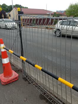 Roads - General —
 Hi, my children and others from Addington School use this crossing daily, which is on a state highway Brougham St but crosses Collins St. It
- Roading/Streets —
the pedestrian/cycle crossing lights on the northern side of the Brougham St crossing didn't seem to be working this morning. After waiting
Graffiti —
Also reported on Collins Street
- 6 Collins Street — 16 reports
- 47 Collins Street — 9 reports
- 50 Collins Street — 8 reports
- 49 Collins Street — 8 reports
- 9 Collins Street — 7 reports
- 7 Collins Street — 6 reports
- 31 Collins Street — 6 reports
- 26A Collins Street — 6 reports
The street’s crash record
NZTA’s record names Collins Street in 12 crashes that hurt somebody since 2006 — 1 person killed, 2 seriously hurt.
The green nearby
- Jerrold Reserve — 53 m to the edge
- Simeon Park — 148 m to the edge · 1 ha
- Addington Park — 302 m to the edge · Sports ground · 3 ha
- Selwyn Reserve — 328 m to the edge
- Mountfort Park — 417 m to the edge · Botanic
Parks within half a kilometre, measured to the boundary — the council’s open data.
The bus nearby
The closest Metro stops, within four hundred and fifty metres.
The tracks through here
- Walk and bike track through Addington — 45 m to the line · walk · bike
- Walk and bike track through Addington — 57 m to the line · walk · bike
- Walk and bike track through Addington — 292 m to the line · walk · bike
- Walk and bike track through Addington — 388 m to the line · walk · bike
- Walk and bike track through Addington — 449 m to the line · walk · bike
Tracks whose line passes within half a kilometre, measured to the line itself — the council’s open data.
The named ground
Named water within 500 m of this address, measured to the line or the edge; Named places within 1.5 km of this address — the open map’s record.
Renting nearby
new bonds in Addington ran about $502 a week — $48 below the city median of $550 — the suburb page keeps the rent record →.
The civic layer
This ground votes in Spreydon ward — the Spreydon-Cashmere-Heathcote community board. Ward lines don’t always follow suburb lines; this one is measured at the pin, not the suburb’s centre.
What stood on this ground → · On the map → · From the air — the Crown’s aerials back to 1936; search the address on RetroLens →
Questions, answered briefly
32 council reports on record since March 2019 — most often pavement - damaged (5), graffiti (5), dumped rubbish (5).
Addington, Christchurch — on Collins Street.
Nothing on the heritage register at this exact spot — the record around this ground →
Jerrold Reserve — 53 m to its edge.