335 Wainoni Road, Avondale
26 reports on record since May 2019 · 22 with photographs. The street’s heaviest record is 336 Wainoni Road — 60 reports on file. Indicative rating valuation and school zones, hazards, bin day and what stood here before.
What gets reported here
Photographed here 22 on record


Reported here
- Roads - General —
Traffic management still in place, no workers, machines or site offices left on site, lane drop in place is dramatically impending traffic h
 Litter —
 In bush and near corner Littering
 Graffiti on a cabinet, pole or railway asset —
  Overgrown Vegetation —
 Corner Wainoni & Anzac Drive, along foot path/cycle way.
 Graffiti on a cabinet, pole or railway asset —
 graffiti on a traffic light pole
 Street Light Outage —
  Damaged Street Sign —
 This sign was flattened about a week ago.
 Graffiti —
  Overgrown Vegetation —
 Between Wainoni Road and New Brighton Road, on Anzac Drive.
 Graffiti —
  Graffiti —
 On traffic light control box
 Graffiti —
 Both sides
 Graffiti —
  Graffiti —
  Graffiti —
  Graffiti —
  Graffiti —
  Graffiti —
  Vandalism - General —
 - Graffiti —
- Graffiti —
 Rubbish and Bins - General —
 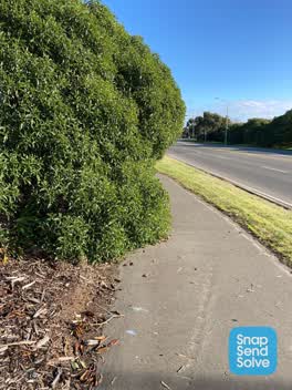 Roading/Streets —
 Very dangerous. Trees encroaching on cycle/footpath. Near miss accident.
- Roading/Streets —
Trees encroaching on cycle/footpath. Almost had an accident with another cyclist. I have reported this several times but have seen no change
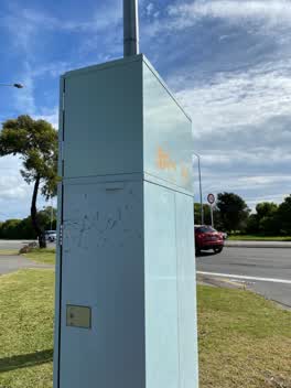 Graffiti —
 Graffiti —
Also reported on Wainoni Road
- 336 Wainoni Road — 60 reports
- 192 Wainoni Road — 31 reports
- 190E Wainoni Road — 15 reports
- 330 Wainoni Road — 14 reports
- 174 Wainoni Road — 14 reports
- 162 Wainoni Road — 13 reports
- 150 Wainoni Road — 11 reports
- 279 Wainoni Road — 10 reports
The street’s crash record
NZTA’s record names Wainoni Road in 80 crashes that hurt somebody since 2006 — 1 person killed, 19 seriously hurt.
The green nearby
- Ripene Ma — 79 m to the edge
- Hulverstone Reserve — 173 m to the edge
- Cockayne Reserve — 237 m to the edge · Regional · 6 ha
- Bower Park — 252 m to the edge · Sports ground · 4 ha
- Cedarwood Reserve — 373 m to the edge · 1 ha
Parks within half a kilometre, measured to the boundary — the council’s open data.
On the doorstep
- The Bower — 339 m away · Bars & pubs
- Urban Corner Cafe — 347 m away · Cafés
- Fast Camel Souvlaki Takeaway — 394 m away · Fast food
- Bower Fish Supply — 395 m away · Fast food
Businesses within four hundred metres, measured at the pin — OpenStreetMap and the council directories.
The bus nearby
- Wainoni Rd near Hampshire St — 79 m away · route 80
- Wainoni Rd near Hampshire St — 92 m away · route 80
The closest Metro stops, within four hundred and fifty metres.
The tracks through here
- Walk and bike track through Avondale — 34 m to the line · walk · bike
- Walk and bike track through Avondale — 70 m to the line · walk · bike
- Walk and bike track through Avondale — 173 m to the line · walk · bike
- Walk and bike track through Avondale — 196 m to the line · walk · bike
- Walk and bike track through Avondale — 231 m to the line · walk · bike
Tracks whose line passes within half a kilometre, measured to the line itself — the council’s open data.
The named ground
Named water within 500 m of this address, measured to the line or the edge — the open map’s record.
The remembered names nearby
- Cockayne Reserve plaque — 249 m away · 1899
Inscribed plaques within two hundred and fifty metres — the register’s pins, not surveyed spots. The whole roll is at /plaques.
Renting nearby
new bonds in Avondale ran about $600 a week — $50 above the city median of $550 — the suburb page keeps the rent record →.
The civic layer
This ground votes in Burwood ward — the Coastal-Burwood-Linwood community board. Ward lines don’t always follow suburb lines; this one is measured at the pin, not the suburb’s centre.
What stood on this ground → · On the map → · From the air — the Crown’s aerials back to 1936; search the address on RetroLens →
Questions, answered briefly
26 council reports on record since May 2019 — most often graffiti (14), roading/streets (2), overgrown vegetation (2).
Avondale, Christchurch — on Wainoni Road.
Nothing on the heritage register at this exact spot — the record around this ground →
Ripene Ma — 79 m to its edge.