4 Jeffreys Road, Burnside
13 reports on record since July 2021 · 7 with photographs. The most-reported address on Jeffreys Road. Indicative rating valuation and school zones, hazards, bin day and what stood here before.
What gets reported here
Photographed here 7 on record


Reported here
 Overgrown Vegetation —
 Remove weeds from Orion building by fendalton library
 Poles and Signage - General —
 Broken bollard. Needs replacing please.
 Abandoned Vehicle —
 Unfortunately, there’s been a break-in on someone’s car parked in the Fendalton library car park
 Park - General Request —
 Broken bollard at the car park at fendalton library car park
 Overgrown Vegetation —
 Hedge outside 188 Clyde Rd extends 1 and a half metres over public footpath and severely limits access
 Rubbish and Bins - General —
 Rubbish bin overflowing at Jeffreys Road reserve
- Rubbish and Bins - General —
- Dumped Rubbish —
- Abandoned Vehicle —
- Abandoned Vehicle —
- Abandoned Vehicle —
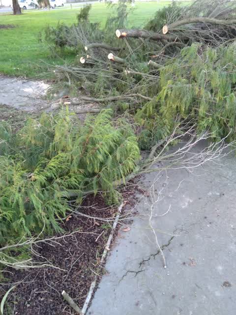
- Trees - General —
 Parks —
 Cut off branches are blocking the path into the reserve and children's playground.
Also reported on Jeffreys Road
- 12 Jeffreys Road — 8 reports
- 4E Jeffreys Road — 4 reports
- 5 Jeffreys Road — 1 report
The street’s crash record
NZTA’s record names Jeffreys Road in 12 crashes that hurt somebody since 2006 — 1 seriously hurt, nobody killed.
The green nearby
- Jeffreys Reserve — 24 m to the edge · 1 ha
- Waiwetu Reserve — 119 m to the edge
- Otara Reserve — 209 m to the edge
Parks within half a kilometre, measured to the boundary — the council’s open data.
The civic shelf nearby
- Fendalton Service Centre — 15 m away · Service centre
- Fendalton Library — 36 m away · Library · Jeffreys Rd, Christchurch 8052
Libraries, halls and the rest within half a kilometre — the council’s open data.
On the doorstep
- Fendalton Community Centre — 194 m away · Venues & events
- 40 Thornycroft Street Bed & Breakfast — 270 m away · B&Bs
- Thornycroft B&B — 273 m away · Guest houses
- Et le Fromage Food/Grocery — 363 m away · Delis
Businesses within four hundred metres, measured at the pin — OpenStreetMap and the council directories.
The bus nearby
The closest Metro stops, within four hundred and fifty metres.
The tracks through here
- Walk and bike track through Burnside — 116 m to the line · walk · bike
- Walk and bike track through Burnside — 142 m to the line · walk · bike
- Walk and bike track through Burnside — 215 m to the line · walk · bike
- Walk and bike track through Burnside — 215 m to the line · walk · bike
- Walk and bike track through Burnside — 288 m to the line · walk · bike
Tracks whose line passes within half a kilometre, measured to the line itself — the council’s open data.
The named ground
Named water within 500 m of this address, measured to the line or the edge; the council’s own structure register — bridges, boardwalks and steps standing nearby — the open map’s record.
The remembered names nearby
- Planted on the Site of the Former Waimairi District Council — 59 m away ·
Planted on the site of the former Waimairi District Council Works Yard in recognition of t
· 2003 - Bring Your Children, As Erin Macneil Would Have Done — 80 m away ·
Bring your children, as Erin Macneil would have done, to enjoy the perfume and ponder the
· 2006 - Bet’S Bench Elizabeth 'Betty' Turner September 1928 — March — 192 m away ·
BET’S BENCH Elizabeth 'Betty' Turner September 1928 — March 2004
· 2006
Inscribed plaques within two hundred and fifty metres — the register’s pins, not surveyed spots. The whole roll is at /plaques.
Renting nearby
new bonds in Burnside ran about $641 a week — $91 above the city median of $550 — the suburb page keeps the rent record →.
The civic layer
This ground votes in Fendalton ward — the Fendalton-Waimairi-Harewood community board. Ward lines don’t always follow suburb lines; this one is measured at the pin, not the suburb’s centre.
What stood on this ground → · On the map → · From the air — the Crown’s aerials back to 1936; search the address on RetroLens →
Questions, answered briefly
13 council reports on record since July 2021 — most often abandoned vehicle (4), rubbish and bins - general (2), overgrown vegetation (2).
Burnside, Christchurch — on Jeffreys Road.
Nothing on the heritage register at this exact spot — the record around this ground →
Jeffreys Reserve — 24 m to its edge, 1 ha.