1700 Summit Road, Cashmere
17 reports on record since March 2024 · 17 with photographs. The most-reported address on Summit Road. Indicative rating valuation and school zones, hazards, bin day and what stood here before.
What gets reported here
Photographed here 17 on record


Reported here
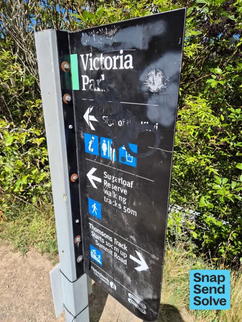
 Graffiti on a sign, mural or public art —
 on sign on summit Rd at start of Harry Ell track near Sign of the Kiwi
 Road Signage —
 Below the summit Rd is 30kph sign. it is only visible if one is walking. north east of sign of the Kiwi junction and Harry Ell track. not ev
 Damaged Street Sign —
 Please realign directional information signs being regularly interfered with at Sign of the Kiwi to stop the intentional misdirection of vis
 Abandoned Vehicle —
 Partially burnt car, GPJ268 Subaru wagon, is blocking limited parking at the Sign of the Kiwi, (Summit and Dyers Pass intersection), Port Hi
 Road Signage —
 Finger post turned 90 degrees
 Poles and Signage - General —
  Graffiti on a fence, building or structure —
 On retaining wall at top of Harry Ell track. This was a few days ago at weekend and may have already been attended.
 General Request —
 No soap in either womens or men's toilets. Very unhealthy! Needs to be checked and filled up daily. So many people use them.
 Park - General Request —
 Heritage stone wall outside park damaged by car crash. Repairs needed urgently or stone will get stolen.
 Damaged Street Sign —
 Metal spikes close to seal edge, that used to have white reflective plastic markers, are now a tripping and tyre puncture hazard. Either rep
 Pavement - General —
 There is no safety barrier between the road and the top of Harry El. This is a huge drop and highly dangerous.
 Road Signage —
 Reflectors missing and the exposed reflector holders are potentially hazardous - easy to trip on.
 Pothole —
 30x30cm pothole on the ascending driving line, directly outside the victoria park walking track
 Pothole —
 Pothole approx 20cm x 20cm on driving line
 Pavement - Damaged —
 One of the metal bike racks is gone and there is a piece of metal tubing sticking up out of ground which could be a potential trip hazard fo
 Graffiti somewhere else —
 Safety barrier at Sign of the Kiwi car park
 Poles and Signage - General —
Also reported on Summit Road
- 1713–1749 Summit Road — 3 reports
- 1703–1709 Summit Road — 3 reports
- 1671–1701 Summit Road — 3 reports
- 1483 Summit Road — 3 reports
- 1801–1807 Summit Road — 2 reports
- 1813–1843 Summit Road — 1 report
- 1811 Summit Road — 1 report
- 1751–1799 Summit Road — 1 report
The street’s crash record
NZTA’s record names Summit Road in 54 crashes that hurt somebody since 2006 — 7 people killed, 13 seriously hurt.
The green nearby
- Marleys Hill — 1 m to the edge · Regional · 21 ha
- Sugarloaf Reserve — 32 m to the edge · Regional · 110 ha
- Coronation Hill Reserve — 59 m to the edge · Regional · 4 ha
- Thomson Scenic Reserve — 152 m to the edge · Regional · 30 ha
- Douglas Scenic Reserve — 402 m to the edge · Regional · 2 ha
Parks within half a kilometre, measured to the boundary — the council’s open data.
On the doorstep
- Sign of the Kiwi — 88 m away · Restaurants
Businesses within four hundred metres, measured at the pin — OpenStreetMap and the council directories.
The tracks through here
- Walk and bike track through Cashmere — 38 m to the line · walk · bike
- Walk and bike track through Cashmere — 65 m to the line · walk · bike
- Walk and bike track through Cashmere — 164 m to the line · walk · bike
Tracks whose line passes within half a kilometre, measured to the line itself — the council’s open data.
The named ground
Named places within 1.5 km of this address; the council’s own structure register — bridges, boardwalks and steps standing nearby — the open map’s record.
The remembered names nearby
- Sister City Garden — 64 m away ·
Sister City Garden / (dedication text partly illegible)
· 2009
Inscribed plaques within two hundred and fifty metres — the register’s pins, not surveyed spots. The whole roll is at /plaques.
Renting nearby
new bonds in Cashmere ran about $707 a week — $157 above the city median of $550 — the suburb page keeps the rent record →.
What was here — Sign of the Kiwi Grounds and Setting
76 m away · 1700 Summit Road · located to ±38 m · the place’s own record →
On the register. Nothing researched here yet.
What was here — Sign of the Kiwi and Setting
86 m away · 1700 Summit Road · located to ±12 m · the place’s own record →
On the register. Nothing researched here yet.
The civic layer
This ground votes in Cashmere ward — the Spreydon-Cashmere-Heathcote community board. Ward lines don’t always follow suburb lines; this one is measured at the pin, not the suburb’s centre.
What stood on this ground → · On the map → · From the air — the Crown’s aerials back to 1936; search the address on RetroLens →
Questions, answered briefly
17 council reports on record since March 2024 — most often road signage (3), pothole (2), poles and signage - general (2).
Cashmere, Christchurch — on Summit Road.
The heritage register names 2 places at or beside it — Sign of the Kiwi Grounds and Setting, Sign of the Kiwi and Setting.
Marleys Hill — 1 m to its edge, 21 ha.