18 Malcolm Avenue, Cashmere
38 reports on record since April 2017 · 27 with photographs. The most-reported address on Malcolm Avenue. Indicative rating valuation and school zones, hazards, bin day and what stood here before.
What gets reported here
Photographed here 27 on record



Reported here
 Graffiti on a playground or in a park —
 Graffiti (sticker) on metal bollard at Malcolm Avenue end of Donkey Track Reserve walkway, Beckenham. Graffiti (sticker) is on the rear surf
 Poles and Signage - General —
 Sign for the Donkey Track has gone missing.
 Graffiti on a road, footpath or bridge —
 Graffiti on Malcolm Avenue road bridge over Heathcote River. Graffiti is on the south side of the square concrete abutment at end of the gua
 Graffiti on a road, footpath or bridge —
 Graffiti areas x2 on Malcolm Avenue road bridge over Heathcote River. Graffiti is on metal railing (yellow paint pen) and white circular “He
 Graffiti on a road, footpath or bridge —
 Graffiti on Malcolm Avenue road bridge over Heathcote River. Graffiti is on the side of the concrete abutment on the south side of the bridg
 Park - General Request —
 Missing Donkey Track information sign at Malcolm Avenue end of Donkey Track reserve walkway (on West Bank of Heathcote River near large brow
 Poles and Signage - General —
 Missing "Safe Routes to School Crossing Point" yellow circular sign on red metal frame at Malcolm Avenue crossing point (crossing near Heath
 Graffiti on a road, footpath or bridge —
 Tagged sign
 Graffiti on a road, footpath or bridge —
 Graffiti at seven (7) locations on Malcolm Avenue road bridge which crosses Heathcote River. The graffiti is a located as shown in attached
 Graffiti on a cabinet, pole or railway asset —
  Graffiti on a playground or in a park —
 Graffiti (sticker) on metal bollard at Malcolm Avenue end of Donkey Track Reserve walkway, Beckenham. Graffiti (sticker) is on the rear surf
 Dumped Rubbish —
 Dumped car parts
 Poles and Signage - General —
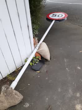
 Donkey track sign broken off pole/laying on the ground. At start of donkey track Malcolm ave end
 Vandalism - General —
 Donkey track sign has been vandalized and thrown in the river
 Dumped Rubbish —
 Dumped road cone
 Rubbish and Bins - General —
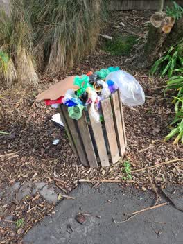
 Bin is full at the end of Donkey Track walkway. Please empty asap
 Rubbish and Bins - General —
 Full bin
 Rubbish and Bins - General —
 Full
 Rubbish and Bins - General —
 Full now
- Rubbish and Bins - General —
- Rubbish and Bins - General —
- Rubbish and Bins - General —
- Rubbish and Bins - General —
- Graffiti —
- Overgrown Vegetation —
- Rubbish and Bins - General —
- Rubbish and Bins - General —
- General Request —
- Rubbish and Bins - General —
- Graffiti —
 Roading/Streets —
  Rubbish/Recycling —
 Rubbish/Recycling —
Parks —
Is this reserve being maintained?
Parks —
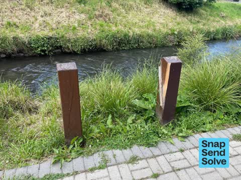
Broken Bollard needs to be replaced
Parks —
Piles of bricks dumped in garden needs picked up and disposed of
Parks —
Broken Bollard needs replaced
Parks —
Very disappointed to find the seat we use every day has disappeared. Can you tell me if it is to be replaced?
Also reported on Malcolm Avenue
- 1 Malcolm Avenue — 20 reports
- 11 Malcolm Avenue — 13 reports
- 5 Malcolm Avenue — 8 reports
- 30E Malcolm Avenue — 8 reports
- 14 Malcolm Avenue — 8 reports
- 30A Malcolm Avenue — 7 reports
- 7 Malcolm Avenue — 5 reports
- 25 Malcolm Avenue — 5 reports
The street’s crash record
NZTA’s record names Malcolm Avenue in 8 crashes that hurt somebody since 2006 — 4 seriously hurt, nobody killed.
The green nearby
- Remuera Reserve — 338 m to the edge
- Ernle Clark Reserve — 371 m to the edge · Botanic · 2 ha
- Waimea Reserve — 379 m to the edge
- Thorrington Reserve — 384 m to the edge
- Rossmore Reserve — 484 m to the edge
Parks within half a kilometre, measured to the boundary — the council’s open data.
The civic shelf nearby
- South Christchurch Library — 434 m away · Library · 66 Colombo St, Cashmere, Christchurch 8022
- Beckenham Service Centre — 436 m away · Service centre
Libraries, halls and the rest within half a kilometre — the council’s open data.
On the doorstep
- Basic Bikes — 178 m away · Bike shops
- OrthodontiX Cashmere — 180 m away · Dentists
- Thorrington Dairy — 180 m away · Dairies & convenience
- Beckenham Cycles — 181 m away · Bike shops
Businesses within four hundred metres, measured at the pin — OpenStreetMap and the council directories.
The bus nearby
- Colombo St near Thorrington Rd — 179 m away · route 1
- Colombo St near Thorrington Rd — 182 m away · route 1
The closest Metro stops, within four hundred and fifty metres.
The tracks through here
- Walk and bike track through Cashmere — 14 m to the line · walk · bike
- Walk and bike track through Cashmere — 38 m to the line · walk · bike
- Walk and bike track through Cashmere — 47 m to the line · walk · bike
- Walk and bike track through Cashmere — 72 m to the line · walk · bike
- Walk and bike track through Cashmere — 76 m to the line · walk · bike
Tracks whose line passes within half a kilometre, measured to the line itself — the council’s open data.
The named ground
Named water within 500 m of this address, measured to the line or the edge; the council’s own structure register — bridges, boardwalks and steps standing nearby — the open map’s record.
Renting nearby
new bonds in Cashmere ran about $707 a week — $157 above the city median of $550 — the suburb page keeps the rent record →.
The civic layer
This ground votes in Cashmere ward — the Spreydon-Cashmere-Heathcote community board. Ward lines don’t always follow suburb lines; this one is measured at the pin, not the suburb’s centre.
What stood on this ground → · On the map → · From the air — the Crown’s aerials back to 1936; search the address on RetroLens →
Questions, answered briefly
38 council reports on record since April 2017 — most often rubbish and bins - general (11), parks (5), graffiti on a road, footpath or bridge (5).
Cashmere, Christchurch — on Malcolm Avenue.
Nothing on the heritage register at this exact spot — the record around this ground →
Remuera Reserve — 338 m to its edge.