57 Cashmere Road, Cashmere
13 reports on record since November 2015 · 11 with photographs. The street’s heaviest record is 73 Cashmere Road — 97 reports on file. Indicative rating valuation and school zones, hazards, bin day and what stood here before.
What gets reported here
- Roading/Streets — 2
- Graffiti — 2
- General Request — 2
- Water Leak — 1
- Trees - General — 1
- Pothole — 1
Photographed here 11 on record



Reported here
 Trees - General —
 Dead branch in Beech tree, at Cashmere Riverbank Reserve, right next to foot path, very busy Reserve. potential hazard.
 Pothole —
 This cover is having its surrounds eroded again.
 Park - General Request —
 3 Bollards have been broken on roadside
 General Request —
 Broken barriers Cashmere Riad please fix. ??
 Poles and Signage - General —
 Been damaged for 2 weeks
 Abandoned Vehicle —
 Toyota Hilux Surf AJD286
 General Request —
 A Maori guy from hib interior plastering stopped and took photos of this. The information could be useful to police. You can tell them.
 Water Leak —
  Overgrown Vegetation —
 Looking untidy & unkempt.
- Graffiti —
- Graffiti —
Roading/Streets —
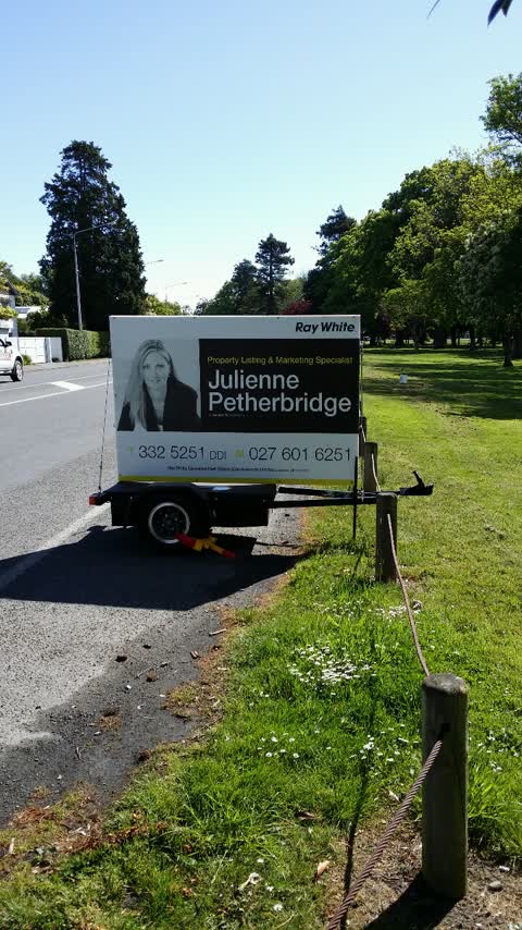
Another billboard. Has been here a week despite being reported.
Roading/Streets —
This billboard on a trailer has returned. Please coukd a consent infringement be issued. Thanks Richard
Also reported on Cashmere Road
- 73 Cashmere Road — 97 reports
- 36 Cashmere Road — 46 reports
- 97 Cashmere Road — 40 reports
- 95 Cashmere Road — 28 reports
- 77 Cashmere Road — 27 reports
- 97R Cashmere Road — 21 reports
- 37 Cashmere Road — 19 reports
- 87 Cashmere Road — 18 reports
The street’s crash record
NZTA’s record names Cashmere Road in 58 crashes that hurt somebody since 2006 — 14 seriously hurt, nobody killed.
The green nearby
- Cashmere Riverbank Reserve — 23 m to the edge · 1 ha
- Cashmere Valley Reserve — 215 m to the edge · 2 ha
- Purau Reserve — 239 m to the edge
- Ernle Clark Reserve — 312 m to the edge · Botanic · 2 ha
Parks within half a kilometre, measured to the boundary — the council’s open data.
On the doorstep
- Cashmere Medical Practice — 112 m away · Doctors & clinics
- Fuse Real Fruit Ice Cream — 238 m away · Ice cream
- Cashmere Bowling Club — 287 m away · Clubs
- Zeroes — 346 m away · Cafés
Businesses within four hundred metres, measured at the pin — OpenStreetMap and the council directories.
The bus nearby
- Cashmere Rd near Crichton Tce — 92 m away · route 1, the Orbiter (clockwise)
- Cashmere Rd near Crichton Tce — 97 m away · route 1, the Orbiter (anticlockwise)
The closest Metro stops, within four hundred and fifty metres.
The tracks through here
- Walk and bike track through Cashmere — 6 m to the line · walk · bike
- Walk and bike track through Cashmere — 10 m to the line · walk · bike
- Walk and bike track through Cashmere — 50 m to the line · walk · bike
- Walk and bike track through Cashmere — 132 m to the line · walk · bike
- Walk and bike track through Cashmere — 170 m to the line · walk · bike
Tracks whose line passes within half a kilometre, measured to the line itself — the council’s open data.
The named ground
Named water within 500 m of this address, measured to the line or the edge; Named places within 1.5 km of this address; the council’s own structure register — bridges, boardwalks and steps standing nearby — the open map’s record.
Renting nearby
new bonds in Cashmere ran about $707 a week — $157 above the city median of $550 — the suburb page keeps the rent record →.
The civic layer
This ground votes in Cashmere ward — the Spreydon-Cashmere-Heathcote community board. Ward lines don’t always follow suburb lines; this one is measured at the pin, not the suburb’s centre.
What stood on this ground → · On the map → · From the air — the Crown’s aerials back to 1936; search the address on RetroLens →
Questions, answered briefly
13 council reports on record since November 2015 — most often roading/streets (2), graffiti (2), general request (2).
Cashmere, Christchurch — on Cashmere Road.
Nothing on the heritage register at this exact spot — the record around this ground →
Cashmere Riverbank Reserve — 23 m to its edge, 1 ha.