544 Memorial Avenue
4 council reports since February 2024, 4 carrying a photograph. The most-reported address on Memorial Avenue.
From the air, then
Sourced from Canterbury Maps and partners. LINZ, CC BY 3.0 NZ. Each frame is cut from Environment Canterbury’s historic imagery MapServer for that decade, only where the Footprints layer names a CC BY survey (NZAM-covered spots stay out). RetroLens holds more Crown aerials →
On the doorstep
- SuRa Teppanyaki, 16 m away · Restaurants
- Lone Star, 34 m away · Restaurants
- Subway, 43 m away · Fast food
- Burger Fuel Spitfire Square, 45 m away · Fast food
Businesses within four hundred metres, measured at the pin, OpenStreetMap and the council directories.
The bus nearby
- Memorial Ave near Spitfire Square, 87 m away · route 3, route 29, route 125
- Memorial Ave near Spitfire Square, 170 m away · route 3, route 29, route 125
The closest Metro stops, within four hundred and fifty metres.
The tracks through here
- Walk and bike track through Christchurch Airport, 36 m to the line · walk · bike
Tracks whose line passes within half a kilometre, the council’s open data.
What gets reported here
Photographed here 4 on record



What’s on record
 Graffiti on a road, footpath or bridge, 19 Sept 2025
are businesses permitted to glue advertisements to the footpath like this? seems no better than graffiti to me.
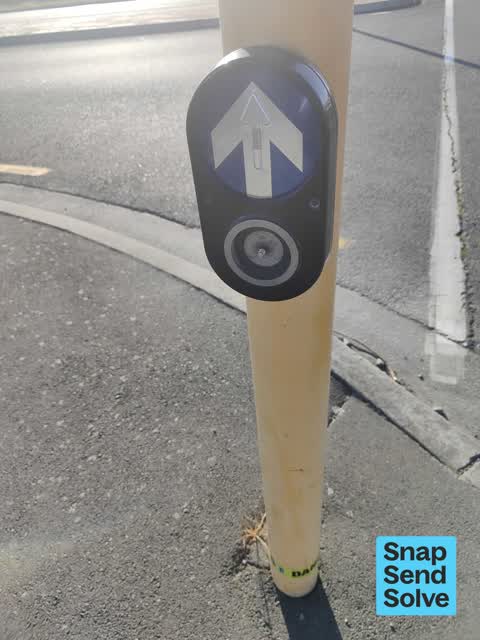
 Poles and Signage - General, 18 Nov 2024
missing button on pedestrian crossing.
 Poles and Signage - General, 9 Aug 2024
Not sure what category to put this under, but the button on this crosswalk has been removed or fallen off. The post in the middle does work
 Hazard, vehicle, 23 Feb 2024
Wanting to know if parking here is legal . It blocks visibility to our business and causes traffic flow issues
Elsewhere on Memorial Avenue
- 546 Memorial Avenue, 4 reports
- 500 Memorial Avenue, 4 reports
- 600m Memorial Avenue, 1 report
- 555 Memorial Avenue, 1 report
- 553 Memorial Avenue, 1 report
- 550 Memorial Avenue, 1 report
- 530/546A Memorial Avenue, 1 report
- 530 Memorial Avenue, 1 report
The street’s crash record
NZTA’s record names Memorial Avenue in 15 crashes that hurt somebody since 2006, 4 seriously hurt, nobody killed.
The civic layer
This ground votes in Harewood ward, the Fendalton-Waimairi-Harewood community board is its local layer. Ward lines don’t always follow suburb lines; this one is measured at the pin, not the suburb’s centre. The whole roll is at /wards.
Memorial Avenue, the whole record → · Everything about Christchurch Airport → · What stood on this ground → · On the map → · From the air, RetroLens holds the Crown’s aerials back to 1936; search the address there →
Questions, answered briefly
4 council reports on record since February 2024, most often poles and signage - general (2), hazard, vehicle (1), graffiti on a road, footpath or bridge (1).
Christchurch Airport, Christchurch, on Memorial Avenue.
Nothing on the heritage register at this exact spot, the record around this ground →