2 Nayland Street, Clifton
16 reports on record since May 2022 · 9 with photographs. The most-reported address on Nayland Street. Indicative rating valuation and school zones, hazards, bin day and what stood here before.
What gets reported here
Photographed here 9 on record


Reported here
 Bus Shelter Issue —
 This bus stop has been out of action since the earthquakes. This fence has been there and being paid for by ratepayers like myself for 15 ye
 Accessibility —
 When are we going to get our footpath back! This site has been taking the mick for over 2 years, closing off to one lane without tmp, parkin
 Accessibility —
 Sorry but this is so hazadous and dangerous when signage is just put on the payment like this .
 Water Leak —
 Leak next door to construction site at 8 The Spur. Been leaking for weeks. Ex red zone property
 Water Leak —
  Water Leak —
 Opposite 3 nayland by where the bike is locked to power pole, water running to waste from burst pipe
 Fallen Tree —
 Large limb off Ngaio has fallen & while still attached to trunk it is at risk of falling further in to cable car entrance, potentially damag
 Poles and Signage - General —
 Pl replace sign for zig zag path on this pole. It has disappeared
- Abandoned Vehicle —
- Street Gutters / Storm Water —
- Damaged Road —
- Street Gutters / Storm Water —
- Water Leak —
- General Request —
- Abandoned Vehicle —
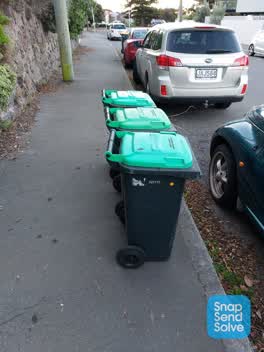 Rubbish/Recycling —
 Green bins not collected
Also reported on Nayland Street
- 5 Nayland Street — 5 reports
- 11 Nayland Street — 5 reports
- 2A Nayland Street — 4 reports
- 7 Nayland Street — 3 reports
- 3 Nayland Street — 2 reports
- 1 Nayland Street — 2 reports
- 2B Nayland Street — 1 report
The street’s crash record
NZTA’s record names Nayland Street in 1 crash that hurt somebody since 2006 — 0 seriously hurt, nobody killed.
The green nearby
- Sumner Beach — 76 m to the edge · Regional · 8 ha
- Sumner Coronation Garden — 128 m to the edge
- Cave Rock Reserve — 268 m to the edge · Regional
- Shag Rock Reserve — 330 m to the edge
- Brownlee Reserve — 350 m to the edge · 3 ha
Parks within half a kilometre, measured to the boundary — the council’s open data.
The civic shelf nearby
- Matuku Takotako/sumner Library — 297 m away · Library · Nayland Street, Sumner
Libraries, halls and the rest within half a kilometre — the council’s open data.
On the doorstep
- Big Bear Breakfast Burritos — 74 m away · Fast food
- Sumner Market — 75 m away · Markets
- Le Petit Hotel — 82 m away · B&Bs
- Sumner Coronation Garden — 177 m away · Attractions
Businesses within four hundred metres, measured at the pin — OpenStreetMap and the council directories.
The bus nearby
- Marriner St near Main Rd — 50 m away · route 3
- Marriner St near Richmond Hill Wlk — 105 m away · route 3
The closest Metro stops, within four hundred and fifty metres.
The tracks through here
- Walk and bike track through Clifton — 66 m to the line · walk · bike
- Walk and bike track through Clifton — 286 m to the line · walk · bike
Tracks whose line passes within half a kilometre, measured to the line itself — the council’s open data.
The named ground
Named places within 1.5 km of this address; the council’s own structure register — bridges, boardwalks and steps standing nearby — the open map’s record.
The remembered names nearby
- In Loving Memory / David John Edgecombe / [] — 131 m away ·
In Loving Memory / DAVID JOHN EDGECOMBE / [illegible] / In Loving Memory / Norm and Audrey
- In Loving Memory / David John Edgecombe / [] — 131 m away ·
In Loving Memory / DAVID JOHN EDGECOMBE / [illegible] / In Loving Memory / Norm and Audrey
Inscribed plaques within two hundred and fifty metres — the register’s pins, not surveyed spots. The whole roll is at /plaques.
Renting nearby
new bonds in Clifton ran about $820 a week — $270 above the city median of $550 — the suburb page keeps the rent record →.
What was here — Dwelling and Setting
78 m away · 1 The Spur · located to ±16 m · the place’s own record →
On the register. Nothing researched here yet.
What was here — The Esplanade War Memorials, Sea Walls and Setting
152 m away · located to ±116 m · the place’s own record →
On the register. Nothing researched here yet.
The civic layer
This ground votes in Heathcote ward — the Spreydon-Cashmere-Heathcote community board. Ward lines don’t always follow suburb lines; this one is measured at the pin, not the suburb’s centre.
What stood on this ground → · On the map → · From the air — the Crown’s aerials back to 1936; search the address on RetroLens →
Questions, answered briefly
16 council reports on record since May 2022 — most often water leak (4), street gutters / storm water (2), accessibility (2).
Clifton, Christchurch — on Nayland Street.
The heritage register names 2 places at or beside it — Dwelling and Setting, The Esplanade War Memorials, Sea Walls and Setting.
Sumner Beach — 76 m to its edge, 8 ha.