14 Glenarm Terrace, Dallington
22 reports on record since January 2019 · 19 with photographs. The most-reported address on Glenarm Terrace. Indicative rating valuation and school zones, hazards, bin day and what stood here before.
What gets reported here
Photographed here 19 on record


Reported here
 Dumped Rubbish —
 dumped green waste
 Park - General Request —
 chain holding gate closed has been cut, gate can’t be closed
 Park - General Request —
 chain cut and gate damaged. redzone entrance near Snell bridge
 Graffiti on a sign, mural or public art —
 on signs at road closure by Avon river corridor
 Park - General Request —
 More dangerous motorbikes in the red zone. almost hit a runner.
 Graffiti on a road, footpath or bridge —
 Tagging under bridge
 Dumped Rubbish —
 Dumped tires on the base of a cabbage tree just inside the Red Zone at Dallington.
 Dumped Rubbish —
 Old carpet mostly
 Dumped Rubbish —
 Dumped rubbish AGAIN
 Dumped Rubbish —
  Dumped Rubbish —
 Dumped alcohol cans etc near white baiters
 Animal - General —
 Dog off leash bit me while I was biking past. Owner was not paying attention.
 Dumped Rubbish —
 Tyre's have been dumped at the end of Glenarm terrace.
 Dumped Rubbish —
 Tyres dumped by glenarm gardens
 Dumped Rubbish —
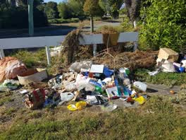
 As per the attached photos, there is a pile of rubbish / household items dumped behind the fencing / blocks on the corner of Glenarm (?) and
 Dumped Rubbish —
 Piles of stuff just dumped roadside
- Dumped Rubbish —
- Hazard — vehicle —
- Dumped Rubbish —
 Rubbish/Recycling —
 roadside dump
Rubbish/Recycling —
A pile of green waste has been dumped near this address next to the gate/barrier here.
Rubbish/Recycling —
Also reported on Glenarm Terrace
- 11 Glenarm Terrace — 11 reports
- 7 Glenarm Terrace — 9 reports
- 9 Glenarm Terrace — 2 reports
- 12 Glenarm Terrace — 2 reports
- 8 Glenarm Terrace — 1 report
- 10 Glenarm Terrace — 1 report
The street’s crash record
NZTA’s record names Glenarm Terrace in 3 crashes that hurt somebody since 2006 — 1 seriously hurt, nobody killed.
The green nearby
- Avon Riverbank True Left — 17 m to the edge · 6 ha
- Avon Park — 88 m to the edge · Sports ground · 6 ha
- Avon Riverbank True Right — 274 m to the edge · 11 ha
- Porritt Park — 441 m to the edge · Sports ground · 11 ha
- Sullivan Park — 496 m to the edge · 1 ha
Parks within half a kilometre, measured to the boundary — the council’s open data.
On the doorstep
- Avon Park Bowling Club — 298 m away · Clubs
Businesses within four hundred metres, measured at the pin — OpenStreetMap and the council directories.
The tracks through here
- Walk and bike track through Dallington — 15 m to the line · walk · bike
- Walk and bike track through Dallington — 73 m to the line · walk · bike
- Walk and bike track through Dallington — 412 m to the line · walk · bike
Tracks whose line passes within half a kilometre, measured to the line itself — the council’s open data.
The named ground
Named water within 500 m of this address, measured to the line or the edge; the council’s own structure register — bridges, boardwalks and steps standing nearby — the open map’s record.
The remembered names nearby
- This Footbridge Was Opened in May 2022 — 73 m away ·
This footbridge was opened in May 2022 / Funded by the Christchurch Earthquake Appeal Trus
· 2023 - Avon Park plaque — 156 m away · 2024
Inscribed plaques within two hundred and fifty metres — the register’s pins, not surveyed spots. The whole roll is at /plaques.
Renting nearby
new bonds in Dallington ran about $520 a week — $30 below the city median of $550 — the suburb page keeps the rent record →.
The civic layer
This ground votes in Burwood ward — the Coastal-Burwood-Linwood community board. Ward lines don’t always follow suburb lines; this one is measured at the pin, not the suburb’s centre.
What stood on this ground → · On the map → · From the air — the Crown’s aerials back to 1936; search the address on RetroLens →
Questions, answered briefly
22 council reports on record since January 2019 — most often dumped rubbish (12), rubbish/recycling (3), park - general request (3).
Dallington, Christchurch — on Glenarm Terrace.
Nothing on the heritage register at this exact spot — the record around this ground →
Avon Riverbank True Left — 17 m to its edge, 6 ha.