71 Locksley Avenue, Dallington
13 reports on record since December 2016 · 9 with photographs. The most-reported address on Locksley Avenue. Indicative rating valuation and school zones, hazards, bin day and what stood here before.
What gets reported here
Photographed here 9 on record


Reported here
 Park - General Request —
 Sign on bridge path needs replacement
 Pavement - General —
 Bridge slippery when icy the black safety strips are too narrow and far apart
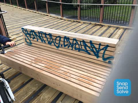
- Graffiti —
- Graffiti —
- Pavement - Damaged —
- Graffiti —
 Graffiti —
  Graffiti —
 On both ends of the bridge
 Graffiti —
  Pavement - Damaged —
 New seal sinking hazard to cyclists
 Graffiti —
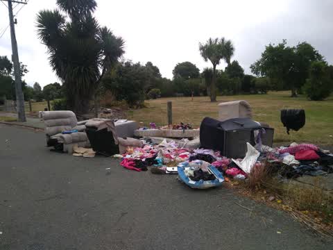
 Rubbish/Recycling —
Rubbish/Recycling —
Also reported on Locksley Avenue
- 73 Locksley Avenue — 12 reports
- 65 Locksley Avenue — 12 reports
- 61 Locksley Avenue — 12 reports
- 3 Locksley Avenue — 11 reports
- 105 Locksley Avenue — 11 reports
- 7 Locksley Avenue — 9 reports
- 63 Locksley Avenue — 7 reports
- 5 Locksley Avenue — 7 reports
The street’s crash record
NZTA’s record names Locksley Avenue in 4 crashes that hurt somebody since 2006 — 1 person killed, 0 seriously hurt.
The green nearby
- Avon Riverbank True Left — 10 m to the edge · 6 ha
- Avon Park — 74 m to the edge · Sports ground · 6 ha
- Avon Riverbank True Right — 342 m to the edge · 11 ha
- Porritt Park — 350 m to the edge · Sports ground · 11 ha
- Halberg Reserve — 430 m to the edge
Parks within half a kilometre, measured to the boundary — the council’s open data.
On the doorstep
- Avon Park Bowling Club — 238 m away · Clubs
Businesses within four hundred metres, measured at the pin — OpenStreetMap and the council directories.
The tracks through here
- Walk and bike track through Dallington — 2 m to the line · walk · bike
- Walk and bike track through Dallington — 46 m to the line · walk · bike
- Walk and bike track through Dallington — 324 m to the line · walk · bike
Tracks whose line passes within half a kilometre, measured to the line itself — the council’s open data.
The named ground
Named water within 500 m of this address, measured to the line or the edge; the council’s own structure register — bridges, boardwalks and steps standing nearby — the open map’s record.
The remembered names nearby
- This Footbridge Was Opened in May 2022 — 28 m away ·
This footbridge was opened in May 2022 / Funded by the Christchurch Earthquake Appeal Trus
· 2023 - Avon Park plaque — 148 m away · 2024
Inscribed plaques within two hundred and fifty metres — the register’s pins, not surveyed spots. The whole roll is at /plaques.
Renting nearby
new bonds in Dallington ran about $520 a week — $30 below the city median of $550 — the suburb page keeps the rent record →.
The civic layer
This ground votes in Burwood ward — the Coastal-Burwood-Linwood community board. Ward lines don’t always follow suburb lines; this one is measured at the pin, not the suburb’s centre.
What stood on this ground → · On the map → · From the air — the Crown’s aerials back to 1936; search the address on RetroLens →
Questions, answered briefly
13 council reports on record since December 2016 — most often graffiti (7), rubbish/recycling (2), pavement - damaged (2).
Dallington, Christchurch — on Locksley Avenue.
Nothing on the heritage register at this exact spot — the record around this ground →
Avon Riverbank True Left — 10 m to its edge, 6 ha.