5 Jetty Road, Governors Bay
18 reports on record since June 2020 · 16 with photographs. The most-reported address on Jetty Road. Indicative rating valuation and school zones, hazards, bin day and what stood here before.
What gets reported here
Photographed here 16 on record


Reported here
 Poles and Signage - General —
 pole has been hit by car. broken up foundation and road surface
 Road Blockage —
 bank/stream washout over walking track
 Graffiti on a fence, building or structure —
 Disgusting graffiti on an electrical cabinet right next to a high traffic walkway
 Overgrown Vegetation —
 Governors Bay foreshore track grass from the jetty to Allandale is very long & a fire hazard. Needs a weedeat
 Graffiti on a fence, building or structure —
 grafitti
 Graffiti on a traffic light pole or cabinet, or wa —
 Tagging on the Governors Bay Jetty
 Graffiti on a traffic light pole or cabinet, or wa —
  Graffiti on a sign, mural or public art —
 - General Request —
There's no life buoys on Governors Bay Jetty. Plenty people swimming when I visit. They should be mandatory.
 Damaged Road —
 Potholes on road located beside Governors Bay jetty to level fill & seal
 Damaged Road —
 Potholes on road to level fill & seal
- Graffiti —
 Graffiti —
  Graffiti —
  Graffiti —
  Parks —
 Trees overhanging popular Sandy Bay to Jetty walking track. Right at head/eye level and spun one could easily get a significant eye injury i
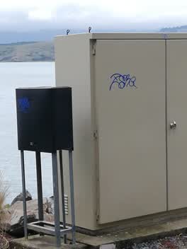 Graffiti —
 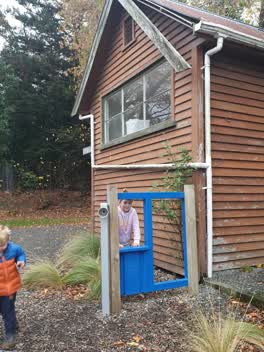 Parks —
 loose fascia over childrens play equipment
Also reported on Jetty Road
- 20 Jetty Road — 7 reports
- 2 Jetty Road — 6 reports
- 35 Jetty Road — 4 reports
- 4 Jetty Road — 3 reports
- 21 Jetty Road — 3 reports
- 1 Jetty Road — 3 reports
- 3-11 Jetty Road — 2 reports
- 18 Jetty Road — 2 reports
The street’s crash record
NZTA’s record names Jetty Road in 2 crashes that hurt somebody since 2006 — 0 seriously hurt, nobody killed.
The green nearby
- Governors Bay Jetty — 4 m to the edge
- Governors Bay Scenic Reserve — 130 m to the edge
- Governors Bay Community Centre And Pool — 298 m to the edge
- Cholmondeley Reserve — 441 m to the edge · 1 ha
- Stream Reserve — 480 m to the edge
Parks within half a kilometre, measured to the boundary — the council’s open data.
On the doorstep
- Govenors Bay Community Centre — 272 m away · Venues & events
- Over The Hill — 353 m away · Cafés
- Harbour House — 355 m away · Cafés
- Ōtoromiro Hotel — 397 m away · Restaurants
Businesses within four hundred metres, measured at the pin — OpenStreetMap and the council directories.
The named ground
Named places within 1.5 km of this address; the council’s own structure register — bridges, boardwalks and steps standing nearby — the open map’s record.
The civic layer
This ground votes in Banks Peninsula ward — the Banks Peninsula community board. Ward lines don’t always follow suburb lines; this one is measured at the pin, not the suburb’s centre.
What stood on this ground → · On the map → · From the air — the Crown’s aerials back to 1936; search the address on RetroLens →
Questions, answered briefly
18 council reports on record since June 2020 — most often graffiti (5), parks (2), graffiti on a traffic light pole or cabinet, or wa (2).
Governors Bay, Christchurch — on Jetty Road.
Nothing on the heritage register at this exact spot — the record around this ground →
Governors Bay Jetty — 4 m to its edge.