1 Hamill Road, Halswell
33 reports on record since October 2018 · 28 with photographs. The most-reported address on Hamill Road. Indicative rating valuation and school zones, hazards, bin day and what stood here before.
What gets reported here
- Water Fountain — 7
- Overgrown Vegetation — 5
- Roading/Streets — 4
- Water Leak — 3
- Street Light Outage — 3
- Litter — 2
Photographed here 28 on record





Reported here
 Pavement - General —
 this business leaves this sign on the footpath 24/7
 General Request —
 The Pint And Pony Sports Bar is giving away alcohol as promoted prize draws to its customers after they purchase drinks to enter prize draw.
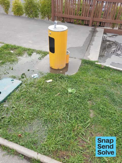
 Water Fountain —
 This has been leaking for over a month now, please fix it
 Water Fountain —
 The dog drinking part is overflowing down the path
 Flooding —
 Water fountain beside playground has flooded, water all over grass and pavement
 Water Fountain —
 This fountain is leaking I think. There is a lot of water around it .
 Water Leak —
 Dog fountain leaking again
 Water Fountain —
 Overflowing, water doesn't stop. Leaking i to ground and drains nearby
 Water Fountain —
 Water fountain is leaking at Longhurst playground outside qubed
 Water Leak —
 Dog fountain outside Qubed coffee house leaking badly
 Park - General Request —
 Steps located in Greenaway park. Edges of steps need highlighting as they blend in. Locals report at least 3 people falling down them.
 Litter —
  Playground Equipment —
 Falling apart
 Overgrown Vegetation —
 Grass hasn’t been mowed, due to the length of the grass my child rolled its ankle
 Overgrown Vegetation —
 Lawns need cut
 Overgrown Vegetation —
  Water Fountain —
 There's water leaking by this fountain. It's by Qubed Coffee Lounge in Longhurst.
 Water Leak —
 Large pool of water around water fountain and in-ground pits. Has been like this for at least a couple of weeks. The water fountain needs wo
 Street Light Outage —
 Strrer light not working outside On the Spot dairy
 Water Fountain —
 There is Gras growing in the fountain
- Street Light Outage —
- Street Light Outage —
- Overgrown Vegetation —
- Overgrown Vegetation —
- Litter —
 Accessibility —
 Debris from flooding making footpath difficult to use
 Flooding —
 The road has become a river and the water is flowing right over the gutters and onto the footpaths. It was like this during last week's down
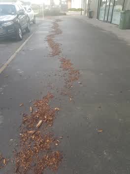 Roading/Streets —
 debris still littering the footpath after the heavy rains from 30th May
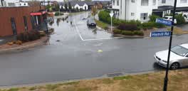 Roading/Streets —
 flooding looks like detritus blocking sumps
Parks —
unsafe, unfinished concrete edge
Wastewater/Stormwater —
a lot of water going within stormwater drain on a hot dry day. very unusual
Roading/Streets —
Footpath narrowed with obstacles
Roading/Streets —
Plastic, silts and other rubbish entering halswell river catchment. Additional bins in the longhurst business area would help resolve much
Also reported on Hamill Road
- 39 Hamill Road — 5 reports
- 16 Hamill Road — 5 reports
- 41 Hamill Road — 3 reports
- 35 Hamill Road — 3 reports
- 42 Hamill Road — 2 reports
- 9 Hamill Road — 1 report
- 51 Hamill Road — 1 report
- 5 Hamill Road — 1 report
The street’s crash record
NZTA’s record names Hamill Road in 1 crash that hurt somebody since 2006 — 0 seriously hurt, nobody killed.
The green nearby
- Alvaston Reserve — 418 m to the edge
- Quaifes Rd Springlands — 464 m to the edge · 10 ha
Parks within half a kilometre, measured to the boundary — the council’s open data.
On the doorstep
- Qubed Coffee Lounge — 2 m away · Restaurants
- Simply Indulge Bakehaus — 9 m away · Cafés
- On the Spot Dairy — 17 m away · Dairies & convenience
- Indian Roots — 18 m away · Restaurants
Businesses within four hundred metres, measured at the pin — OpenStreetMap and the council directories.
The bus nearby
The closest Metro stops, within four hundred and fifty metres.
The named ground
Named places within 1.5 km of this address; the council’s own structure register — bridges, boardwalks and steps standing nearby — the open map’s record.
Renting nearby
new bonds in Halswell ran about $697 a week — $147 above the city median of $550 — the suburb page keeps the rent record →.
The civic layer
This ground votes in Halswell ward — the Halswell-Hornby-Riccarton community board. Ward lines don’t always follow suburb lines; this one is measured at the pin, not the suburb’s centre.
What stood on this ground → · On the map → · From the air — the Crown’s aerials back to 1936; search the address on RetroLens →
Questions, answered briefly
33 council reports on record since October 2018 — most often water fountain (7), overgrown vegetation (5), roading/streets (4).
Halswell, Christchurch — on Hamill Road.
Nothing on the heritage register at this exact spot — the record around this ground →
Alvaston Reserve — 418 m to its edge.