10 Marsack Crescent, Halswell
11 reports on record since November 2021 · 8 with photographs. The most-reported address on Marsack Crescent. Indicative rating valuation and school zones, hazards, bin day and what stood here before.
What gets reported here
- Dumped Rubbish — 4
- Parks — 2
- Overgrown Vegetation — 2
- Park - General Request — 1
- Litter — 1
- Flooding — 1
Photographed here 8 on record


Reported here
 Dumped Rubbish —
 Further to 6677865 (July 2025) the hedge trimmings have yet to be picked up and now the area is becoming a dumping ground for other unwanted
 Dumped Rubbish —
 Neighbourhood had a tidy up and the leaves/hedge trimming need to be collected.
 Dumped Rubbish —
 Cuttings from hedge trimming (completed properly by local residents) have been added to pile of weeds reported 27/12/24 (5604726) and need t
 Dumped Rubbish —
 Pile of green waste dumped in Forgan Reserve. Needs to be cleared urgently before it becomes a fire risk.
 Flooding —
 Neither drains at intersection of Marsack and Edmund Storr are draining effectively. Water is across the road
 Litter —
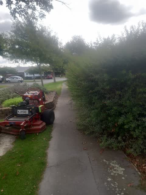
 Hedge clippings need picked up. For the third year in a row local residents have had to tend to the hedge by the Forgan Lane tennis courts.
- Park - General Request —
- Overgrown Vegetation —
- Overgrown Vegetation —
 Parks —
 Residents angry about this bush.
 Parks —
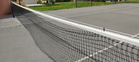
 We often ply tennis at nearby Marsack Crescent court. Net needs replacing/ repairs and netting fence needs several holes repairing.
Also reported on Marsack Crescent
- 7 Marsack Crescent — 6 reports
- 47 Marsack Crescent — 6 reports
- 28 Marsack Crescent — 6 reports
- 7A Marsack Crescent — 4 reports
- 43 Marsack Crescent — 2 reports
- 39 Marsack Crescent — 2 reports
- 37 Marsack Crescent — 2 reports
- 19 Marsack Crescent — 2 reports
The street’s crash record
NZTA’s record names Marsack Crescent in 1 crash that hurt somebody since 2006 — 0 seriously hurt, nobody killed.
The green nearby
- Forgan Reserve — you are in it
- John Olliver Reserve — 93 m to the edge · 2 ha
- Milns Reserve — 229 m to the edge
- Milns Drainage Reserve — 251 m to the edge · 1 ha
- Halswell Domain — 302 m to the edge · Sports ground · 26 ha
Parks within half a kilometre, measured to the boundary — the council’s open data.
On the doorstep
- Banbury Park Village — 345 m away · Business
Businesses within four hundred metres, measured at the pin — OpenStreetMap and the council directories.
The tracks through here
- Walk and bike track through Halswell — 130 m to the line · walk · bike
Tracks whose line passes within half a kilometre, measured to the line itself — the council’s open data.
The named ground
Named water within 500 m of this address, measured to the line or the edge; the council’s own structure register — bridges, boardwalks and steps standing nearby — the open map’s record.
Renting nearby
new bonds in Halswell ran about $697 a week — $147 above the city median of $550 — the suburb page keeps the rent record →.
The civic layer
This ground votes in Halswell ward — the Halswell-Hornby-Riccarton community board. Ward lines don’t always follow suburb lines; this one is measured at the pin, not the suburb’s centre.
What stood on this ground → · On the map → · From the air — the Crown’s aerials back to 1936; search the address on RetroLens →
Questions, answered briefly
11 council reports on record since November 2021 — most often dumped rubbish (4), parks (2), overgrown vegetation (2).
Halswell, Christchurch — on Marsack Crescent.
Nothing on the heritage register at this exact spot — the record around this ground →
Forgan Reserve — the address is inside it.