351 Wigram Road, Halswell
11 reports on record since February 2018 · 8 with photographs. The most-reported address on Wigram Road. Indicative rating valuation and school zones, hazards, bin day and what stood here before.
What gets reported here
- Roads - General — 4
- Park - General Request — 3
- Parks — 2
- Rubbish/Recycling — 1
- Overgrown Vegetation — 1
Photographed here 8 on record



Reported here
 Roads - General —
 Centre line road markings on Wigram Rd need to be realigned to reflect change caused by new housing between 349 Wigram Rd and Riverton Terr
 Park - General Request —
 Compliments to the Parks maintenance teams for the continued improvements in Parks generally, and specifically for the path/turf edging that
 Roads - General —
 Road centre line markings from approx Westlake Park need to be realigned to match the section between Sholto Duncan Crescent and the roundab
 Roads - General —
 Road is corrugated on both sides, multiple pot holes have been filled but makes for rutted surface. A longer lasting solution would be to ac
 Roads - General —
 Vehicles are having to cross the centreline into oncoming traffic while driving through this worksite.
- Park - General Request —
- Overgrown Vegetation —
- Park - General Request —
 Rubbish/Recycling —
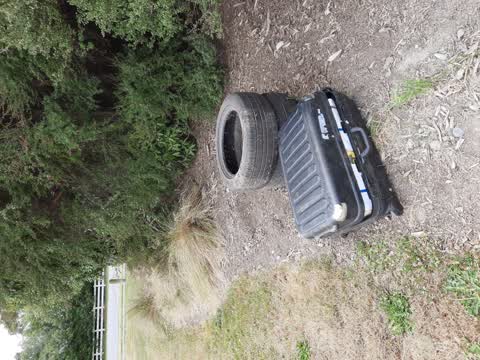
 suitcase filled with undelivered leaflets including name and address and 2 tyres
 Parks —
 suitcase recently dumped in park border next to my property 349 Wigram Rd. Heavy, full of magazines. Also 2 car tyres, which have been in s
Parks —
Wasp Nest- have been stung by waps on 2 recent occasions at this garden border approx 20m in from footpath. Fairly sure there are wasp track
Also reported on Wigram Road
- 349 Wigram Road — 11 reports
- 373 Wigram Road — 8 reports
- 440 Wigram Road — 5 reports
- 410 Wigram Road — 5 reports
- 396R Wigram Road — 5 reports
- 421 Wigram Road — 4 reports
- 416-438 Wigram Road — 4 reports
- 396 Wigram Road — 4 reports
The street’s crash record
NZTA’s record names Wigram Road in 13 crashes that hurt somebody since 2006 — 6 seriously hurt, nobody killed.
The green nearby
- Westlake Reserve — you are in it · Sports ground · 11 ha
- Carrs South Basin Drainage Reserve — 178 m to the edge · 3 ha
- Carrs Reserve — 247 m to the edge · Sports ground · 13 ha
- Carrs North Basin Drainage Reserve — 417 m to the edge · 4 ha
Parks within half a kilometre, measured to the boundary — the council’s open data.
The bus nearby
- Westlake — 368 m away · route 125
The closest Metro stops, within four hundred and fifty metres.
The tracks through here
- Walk and bike track through Halswell — 27 m to the line · walk · bike
- Walk and bike track through Halswell — 35 m to the line · walk · bike
- Walk and bike track through Halswell — 230 m to the line · walk · bike
- Walk and bike track through Halswell — 328 m to the line · walk · bike
- Walk and bike track through Halswell — 429 m to the line · walk · bike
Tracks whose line passes within half a kilometre, measured to the line itself — the council’s open data.
The named ground
Named water within 500 m of this address, measured to the line or the edge; Named places within 1.5 km of this address; the council’s own structure register — bridges, boardwalks and steps standing nearby — the open map’s record.
Renting nearby
new bonds in Halswell ran about $697 a week — $147 above the city median of $550 — the suburb page keeps the rent record →.
The civic layer
This ground votes in Halswell ward — the Halswell-Hornby-Riccarton community board. Ward lines don’t always follow suburb lines; this one is measured at the pin, not the suburb’s centre.
What stood on this ground → · On the map → · From the air — the Crown’s aerials back to 1936; search the address on RetroLens →
Questions, answered briefly
11 council reports on record since February 2018 — most often roads - general (4), park - general request (3), parks (2).
Halswell, Christchurch — on Wigram Road.
Nothing on the heritage register at this exact spot — the record around this ground →
Westlake Reserve — the address is inside it, 11 ha.