5 Annex Road
10 council reports since January 2024, 10 carrying a photograph. The street’s heaviest record is 190 Annex Road, 45 reports on file.
From the air, then
Sourced from Canterbury Maps and partners. RNZAF, CC BY 3.0 NZ. Each frame is cut from Environment Canterbury’s historic imagery MapServer for that decade, only where the Footprints layer names a CC BY survey (NZAM-covered spots stay out). RetroLens holds more Crown aerials →
The green nearby
- Spreydon Riverbank Reserves, 7 m to the edge · 1 ha
- Seager Park, 15 m to the edge · 3 ha · playground, 19 pieces
- Sunnyside Heritage Garden, 56 m to the edge · Botanic · 1 ha
- Albion Reserve, 186 m to the edge
- Pavilion Park, 234 m to the edge
Parks within half a kilometre, measured to the boundary, the council’s open data. The whole roll is at /parks.
On the doorstep
- Hillmed Health Centre, 225 m away · Doctors & clinics
- Bills Bar And Bistro, 226 m away · Bars & pubs
- Tasty Pizza, 226 m away · Fast food
- Big Daddy's Liquor - Hillmorton, 228 m away · Bottle stores
Businesses within four hundred metres, measured at the pin, OpenStreetMap and the council directories.
The bus nearby
The closest Metro stops, within four hundred and fifty metres.
The tracks through here
- Walk and bike track through Hillmorton, 2 m to the line · walk · bike
- Walk and bike track through Hillmorton, 195 m to the line · walk · bike
- Walk and bike track through Hillmorton, 209 m to the line · walk · bike
- Walk and bike track through Hillmorton, 259 m to the line · walk · bike
- Walk and bike track through Hillmorton, 267 m to the line · walk · bike
Tracks whose line passes within half a kilometre, the council’s open data.
The named ground
Named water within 500 m of this address, measured to the line or the edge; Named places within 1.5 km of this address; the council’s own structure register, bridges, boardwalks and steps standing nearby, the open map’s record.
Renting nearby
new bonds in Hillmorton ran about $590 a week, $40 above the city median of $550, the suburb page keeps the rent record →.
What gets reported here
- Overgrown Vegetation, 7
- Poles and Signage - General, 1
- Facility - General Request, 1
- Dumped Rubbish, 1
Photographed here 10 on record





What’s on record
 Poles and Signage - General, 18 Jan 2026
 Graffiti on multiple poles
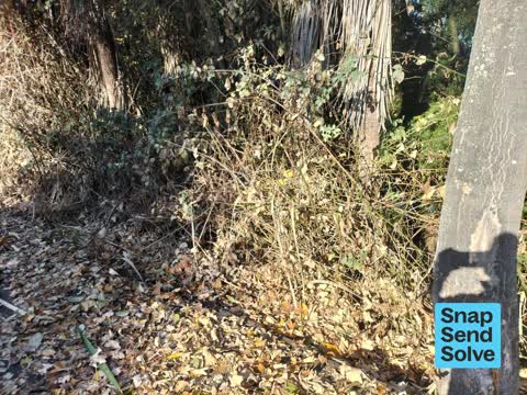
 Overgrown Vegetation, 13 Feb 2025
 Blackberry is protruding onto the footpath/bike lane on a corner, which could result in a collision between folks avoiding it
 Overgrown Vegetation, 3 Feb 2025
 Overgrown Vegetation, 10 Dec 2024
 Since kind of vicious bramble slashed my arm on the cycle way. Vines are growing out into the shared cycle path. Location - As the cycle pa
 Overgrown Vegetation, 1 Dec 2024
 Seems pretty pointless sending to this app...nothing gets done.Have sentvthis and other snaps many times.This is not a wildflower berm it's
 Facility - General Request, 21 Sept 2024
 I was told on my query re where did the bench go that there was never a bench there overlooking the water. As you can see there was a bench
 Dumped Rubbish, 30 Jun 2024
 Load of soil brick bubbles dumped just on Annex Rd pavement by the park
 Overgrown Vegetation, 30 May 2024
 Blackberry needs removing
 Overgrown Vegetation, 6 Feb 2024
 Blackberry is growing over the path on a blind corner
 Overgrown Vegetation, 31 Jan 2024
Elsewhere on Annex Road
- 190 Annex Road, 45 reports
- 11R Annex Road, 23 reports
- 13 Annex Road, 14 reports
- 7R Annex Road, 12 reports
- 17 Annex Road, 11 reports
- 32 Annex Road, 10 reports
- 31 Annex Road, 9 reports
- 201R Annex Road, 8 reports
The street’s crash record
NZTA’s record names Annex Road in 8 crashes that hurt somebody since 2006, 1 person killed, 0 seriously hurt.
The civic layer
This ground votes in Spreydon ward, the Spreydon-Cashmere-Heathcote community board is its local layer. Ward lines don’t always follow suburb lines; this one is measured at the pin, not the suburb’s centre. The whole roll is at /wards.
Annex Road, the whole record → · Everything about Hillmorton → · What stood on this ground → · On the map → · From the air, RetroLens holds the Crown’s aerials back to 1936; search the address there →
Questions, answered briefly
10 council reports on record since January 2024, most often overgrown vegetation (7), poles and signage - general (1), facility - general request (1).
Hillmorton, Christchurch, on Annex Road.
Nothing on the heritage register at this exact spot, the record around this ground →
Spreydon Riverbank Reserves, 7 m to its edge, 1 ha.