1 Leistrella Road, Hoon Hay
14 reports on record since February 2022 · 11 with photographs. The most-reported address on Leistrella Road. Indicative rating valuation and school zones, hazards, bin day and what stood here before.
What gets reported here
- Overgrown Vegetation — 8
- Water General — 2
- Pavement - Damaged — 2
- Roading/Streets — 1
- Accessibility — 1
Photographed here 11 on record




Reported here
 Water General —
  Overgrown Vegetation —
  Accessibility —
 Very dangerous.
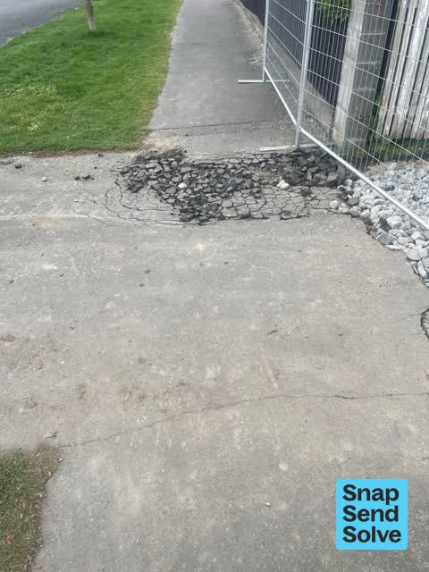
 Pavement - Damaged —
  Pavement - Damaged —
 Hazard. The area should be coned off if they are working here. I just saw someone trip trying to walk over it.
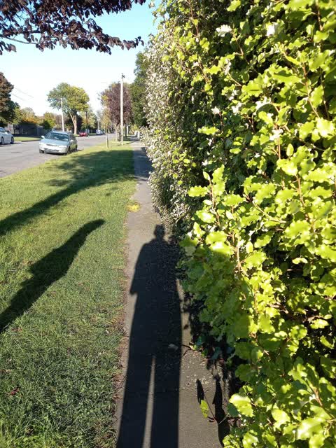
 Overgrown Vegetation —
 Half the footpath is blocked. I've reported this lots before and it's never fixed properly
 Overgrown Vegetation —
 Hi. I see that the hedge had been trimmed but they haven't taken nearly enough off it. It's still taking up half the footpath.
 Overgrown Vegetation —
 Hedge almost taking up the whole footpath
 Overgrown Vegetation —
 The footpath is about 1500mm wide but about 1000mm is covered by vegetation. This makes it very hard to walk with my family on the footpath.
 Overgrown Vegetation —
 - Overgrown Vegetation —
- Overgrown Vegetation —
- Water General —
 Roading/Streets —
 Overgrown hedge makes it very hard to use this footpath, on wet mornings the grass burm is muddy and slippery from people having to walk on
Also reported on Leistrella Road
- 3A Leistrella Road — 4 reports
- 9 Leistrella Road — 3 reports
- 6 Leistrella Road — 3 reports
- 35 Leistrella Road — 3 reports
- 2 Leistrella Road — 3 reports
- 11 Leistrella Road — 3 reports
- 9B Leistrella Road — 2 reports
- 8 Leistrella Road — 2 reports
The street’s crash record
NZTA’s record names Leistrella Road in 2 crashes that hurt somebody since 2006 — 2 seriously hurt, nobody killed.
The green nearby
- Centennial Park — 116 m to the edge · Sports ground · 10 ha
- Hoon Hay Scouts Reserve — 292 m to the edge
- Kaiwara Reserve — 343 m to the edge
- Rydal Reserve — 343 m to the edge
Parks within half a kilometre, measured to the boundary — the council’s open data.
The civic shelf nearby
- Pioneer — 449 m away · Recreation centre · 61 Lyttelton Street
Libraries, halls and the rest within half a kilometre — the council’s open data.
On the doorstep
- Royal Indian — 48 m away · Fast food
- Better Life Dairy — 54 m away · Dairies & convenience
- Style Plus — 60 m away · Hairdressers
- Phoenix Chinese Takeaways — 95 m away · Fast food
Businesses within four hundred metres, measured at the pin — OpenStreetMap and the council directories.
The bus nearby
- Rose St near Hoon Hay Rd — 63 m away · route 44, the Orbiter (anticlockwise)
- Rose St near Hoon Hay Rd — 130 m away · route 44, the Orbiter (clockwise)
The closest Metro stops, within four hundred and fifty metres.
The tracks through here
- Walk and bike track through Hoon Hay — 178 m to the line · walk · bike
- Walk and bike track through Hoon Hay — 182 m to the line · walk · bike
Tracks whose line passes within half a kilometre, measured to the line itself — the council’s open data.
The named ground
Named water within 500 m of this address, measured to the line or the edge — the open map’s record.
Renting nearby
new bonds in Hoon Hay ran about $573 a week — $23 above the city median of $550 — the suburb page keeps the rent record →.
The civic layer
This ground votes in Spreydon ward — the Spreydon-Cashmere-Heathcote community board. Ward lines don’t always follow suburb lines; this one is measured at the pin, not the suburb’s centre.
What stood on this ground → · On the map → · From the air — the Crown’s aerials back to 1936; search the address on RetroLens →
Questions, answered briefly
14 council reports on record since February 2022 — most often overgrown vegetation (8), water general (2), pavement - damaged (2).
Hoon Hay, Christchurch — on Leistrella Road.
Nothing on the heritage register at this exact spot — the record around this ground →
Centennial Park — 116 m to its edge, 10 ha.