64 Neill Street, Hornby
15 reports on record since December 2019 · 14 with photographs. The street’s heaviest record is 4 Neill Street — 18 reports on file. Indicative rating valuation and school zones, hazards, bin day and what stood here before.
What gets reported here
- Overgrown Vegetation — 4
- Parks — 2
- Park - General Request — 2
- Graffiti — 2
- Dumped Rubbish — 2
- Poles and Signage - General — 1
Photographed here 14 on record


Reported here
 General Request —
 Just a poster with event on 6th April
 Graffiti on a playground or in a park —
 On sign post for Oakhampton reserve on Neill st side. And the tree and grasses need attending to as well many thanks. Have a Summer with ne
 Dumped Rubbish —
 This is the same TV cabinet reported on Thursday. Someone, possibly the mowing contractor, has moved it, and there is now broken glass on
 Dumped Rubbish —
 TV cabinet and broken glass.
 Park - General Request —
 Fire recently lit in dry grass vegetation along walkway fence, FENZ attended, neighbours are nervous more will be lit at a later date, would
 Poles and Signage - General —
 Some person set this vegetation on fire earlier this week at Oakhamton reserve found it last night about 3.45pm.
 Overgrown Vegetation —
 Needs a clean up
 Overgrown Vegetation —
 Blocking park signage
 Graffiti —
 On entrance to park fence
- Overgrown Vegetation —
 Graffiti —
  Overgrown Vegetation —
  Park - General Request —
 No signage on what the park is and park rules
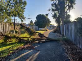 Parks —
 Oakhampton park hornby fell during the night saturday
Parks —
excessive amounts of cabbage tree leaves
Also reported on Neill Street
- 4 Neill Street — 18 reports
- 60 Neill Street — 11 reports
- 106 Neill Street — 11 reports
- 5-7 Neill Street — 7 reports
- 1 Neill Street — 7 reports
- 9 Neill Street — 6 reports
- 6 Neill Street — 6 reports
- 7 Neill Street — 5 reports
The street’s crash record
NZTA’s record names Neill Street in 15 crashes that hurt somebody since 2006 — 2 seriously hurt, nobody killed.
The green nearby
- Oakhampton Reserve — you are in it
- Bermuda Reserve — 253 m to the edge
- Trevor Reserve — 360 m to the edge
- Rollerdrome Reserve — 483 m to the edge · Sports ground
Parks within half a kilometre, measured to the boundary — the council’s open data.
The bus nearby
- Springs Rd near Dufek Cres — 355 m away · route 80
- Springs Rd near Dufek Cres — 369 m away · route 80
The closest Metro stops, within four hundred and fifty metres.
The tracks through here
- Walk and bike track through Hornby — 438 m to the line · walk · bike
Tracks whose line passes within half a kilometre, measured to the line itself — the council’s open data.
Renting nearby
new bonds in Hornby ran about $550 a week — about the city median — the suburb page keeps the rent record →.
The civic layer
This ground votes in Hornby ward — the Halswell-Hornby-Riccarton community board. Ward lines don’t always follow suburb lines; this one is measured at the pin, not the suburb’s centre.
What stood on this ground → · On the map → · From the air — the Crown’s aerials back to 1936; search the address on RetroLens →
Questions, answered briefly
15 council reports on record since December 2019 — most often overgrown vegetation (4), parks (2), park - general request (2).
Hornby, Christchurch — on Neill Street.
Nothing on the heritage register at this exact spot — the record around this ground →
Oakhampton Reserve — the address is inside it.