16 Church Road
1 council report since September 2017, 1 carrying a photograph. The street’s heaviest record is 6 Church Road, 2 reports on file.
The green nearby
- Little River Esplanade Reserve, 312 m to the edge
- Little River Education House, 434 m to the edge · 1 ha
Parks within half a kilometre, measured to the boundary, the council’s open data. The whole roll is at /parks.
The civic shelf nearby
- Little River Cemetery, 233 m away · Cemetery
- Western Valley Road Collection Point, 377 m away · Transfer station
Libraries, halls and the rest within half a kilometre, the council’s open data.
The named ground
Named water within 500 m of this address, measured to the line or the edge, the open map’s record.
What gets reported here
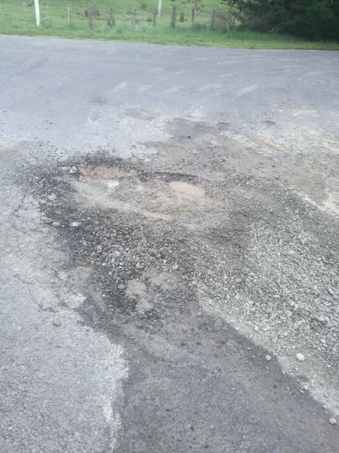
Photographed here 1 on record
What’s on record
Roading/Streets, 26 Sept 2017
This hole has been here 4 weeks and has been reported several times to the service centre in Little River
Elsewhere on Church Road
- 6 Church Road, 2 reports
- 54 Church Road, 1 report
- 11–43 Church Road, 1 report
The street’s crash record
NZTA’s record names Church Road in 1 crash that hurt somebody since 2006, 1 seriously hurt, nobody killed.
The civic layer
This ground votes in Banks Peninsula ward, the Banks Peninsula community board is its local layer. Ward lines don’t always follow suburb lines; this one is measured at the pin, not the suburb’s centre. The whole roll is at /wards.
Church Road, the whole record → · Everything about Little River → · What stood on this ground → · On the map → · From the air, RetroLens holds the Crown’s aerials back to 1936; search the address there →
Questions, answered briefly
1 council report on record since September 2017, most often roading/streets (1).
Little River, Christchurch, on Church Road.
Nothing on the heritage register at this exact spot, the record around this ground →
Little River Esplanade Reserve, 312 m to its edge.