18 Vulcan Place, Middleton
22 reports on record since December 2019 · 22 with photographs. The street’s heaviest record is 16 Vulcan Place — 50 reports on file. Indicative rating valuation and school zones, hazards, bin day and what stood here before.
What gets reported here
Photographed here 22 on record



Reported here
 Graffiti on a fence, building or structure —
 graffiti along walkway
 Graffiti on a fence, building or structure —
 Graffitti on building wall along cycleway
 Graffiti on a fence, building or structure —
  Graffiti on a fence, building or structure —
  Graffiti on a fence, building or structure —
  Graffiti on a fence, building or structure —
 Graffiti on walkway
 Graffiti on a fence, building or structure —
 Tag on building
 Graffiti on a fence, building or structure —
 On building
 Graffiti on a fence, building or structure —
  Graffiti on a fence, building or structure —
  Graffiti on a fence, building or structure —
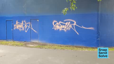
 On blue building
 Graffiti on a fence, building or structure —
  Graffiti on a fence, building or structure —
 2 tags on blue building
 Graffiti on a fence, building or structure —
 Graffiti on building fence, and adjoining property
 Graffiti —
 On building wall
 Graffiti —
 On building wall
Graffiti —
Graffiti —
Graffiti —
Graffiti —
Graffiti —
Graffiti —
Also reported on Vulcan Place
- 16 Vulcan Place — 50 reports
- 15 Vulcan Place — 50 reports
- 12 Vulcan Place — 46 reports
- 9 Vulcan Place — 7 reports
- 18B Vulcan Place — 4 reports
- 7C Vulcan Place — 2 reports
- 5 Vulcan Place — 2 reports
- 2 Vulcan Place — 1 report
The green nearby
- Marylands Reserve — 8 m to the edge · Sports ground · 6 ha
- Mokihi Reserve — 490 m to the edge
Parks within half a kilometre, measured to the boundary — the council’s open data.
On the doorstep
- Regional Forensic Psychiatric Service — 184 m away · Hospital
- Nutrient Depot — 226 m away · Cafés
- Pure Cafe Co - Birmingham Drive — 239 m away · Cafés
- New Zealand Red cross — 271 m away · Ngo
Businesses within four hundred metres, measured at the pin — OpenStreetMap and the council directories.
The bus nearby
- Birmingham Dr near Craft Pl — 228 m away · route 140
- Birmingham Dr near Craft Pl — 240 m away · route 140
The closest Metro stops, within four hundred and fifty metres.
The tracks through here
- Walk and bike track through Middleton — 13 m to the line · walk · bike
- Walk and bike track through Middleton — 115 m to the line · walk · bike
- Walk and bike track through Middleton — 116 m to the line · walk · bike
- Walk and bike track through Middleton — 142 m to the line · walk · bike
- Walk and bike track through Middleton — 342 m to the line · walk · bike
Tracks whose line passes within half a kilometre, measured to the line itself — the council’s open data.
The named ground
Named water within 500 m of this address, measured to the line or the edge; Named places within 1.5 km of this address — the open map’s record.
The civic layer
This ground votes in Spreydon ward — the Spreydon-Cashmere-Heathcote community board. Ward lines don’t always follow suburb lines; this one is measured at the pin, not the suburb’s centre.
What stood on this ground → · On the map → · From the air — the Crown’s aerials back to 1936; search the address on RetroLens →
Questions, answered briefly
22 council reports on record since December 2019 — most often graffiti on a fence, building or structure (14), graffiti (8).
Middleton, Christchurch — on Vulcan Place.
Nothing on the heritage register at this exact spot — the record around this ground →
Marylands Reserve — 8 m to its edge, 6 ha.