8 Wigram Road, Middleton
12 reports on record since May 2017 · 8 with photographs. The most-reported address on Wigram Road. Indicative rating valuation and school zones, hazards, bin day and what stood here before.
What gets reported here
Photographed here 8 on record






Reported here
 Pavement - General —
 Sorry I didn’t get a photo but there’s some broken glass on this part of the footpath as well leading up to the overpass
 Graffiti on a road, footpath or bridge —
 Tag on roadside concrete barrier on overpass
 Graffiti on a traffic light pole or cabinet, or wa —
 Light pole
 Water Leak —
 Water meter/ isolation valve on boundary leaking
 Graffiti on a fence, building or structure —
 Graffiti appeared on the fence beside workshipp overnight at 8 wigram road, Middleton, also on phone/power box infront of building. Have a p
- Hazard — vehicle —
- Parks —
Kerbside planting and grass on northern side of Wigram Rd next to Magdala Pl in a very scrappy condition. Weeds growing up through the kerb.
Roading/Streets —
Vehicles regularly parked on pavement outside HarrisonBloy Plumbing forcing pedestrians either onto business property (potentially with fork
Roading/Streets —
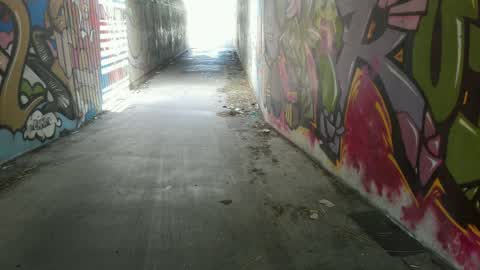
Location is the Annex Rd motorway under pass - the cycleway. There's so much litter and rubbish building up in there we'll soon be down to o
- Roading/Streets —
Ute with license plate BS339 parked on pavement, blocking the full width of the pedestrian space. Pedestrians had to go onto busy Wigram Rd
- Roading/Streets —
Debris (either industrial or from a crash weeks ago at the intersection) in the on-road cycle lane (southern side of Wigram Rd) and some on
Roading/Streets —
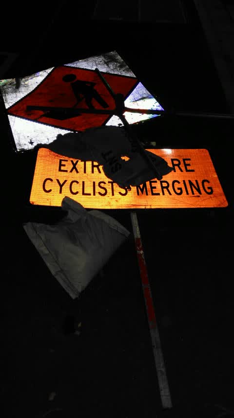
Pile of roadworks signs have been on the footpath for weeks
Also reported on Wigram Road
- 6 Wigram Road — 4 reports
- 6–8 Wigram Road — 1 report
The street’s crash record
NZTA’s record names Wigram Road in 1 crash that hurt somebody since 2006 — 0 seriously hurt, nobody killed.
The green nearby
- Marylands Reserve — 264 m to the edge · Sports ground · 6 ha
- Canterbury Agricultural Park — 436 m to the edge · Sports ground · 42 ha
Parks within half a kilometre, measured to the boundary — the council’s open data.
On the doorstep
- Harrison Bloy — 137 m away · Business
- Annex Pantry — 153 m away · Fast food
- Armstrong — 197 m away · Locksmiths
- Cafe Kudos — 202 m away · Cafés
Businesses within four hundred metres, measured at the pin — OpenStreetMap and the council directories.
The bus nearby
- Annex Rd near Birmingham Dr — 184 m away · route 140
- Annex Rd near Nazareth Ave — 188 m away · route 140
The closest Metro stops, within four hundred and fifty metres.
The tracks through here
- Walk and bike track through Middleton — 167 m to the line · walk · bike
- Walk and bike track through Middleton — 168 m to the line · walk · bike
- Walk and bike track through Middleton — 272 m to the line · walk · bike
- Walk and bike track through Middleton — 291 m to the line · walk · bike
- Walk and bike track through Middleton — 359 m to the line · walk · bike
Tracks whose line passes within half a kilometre, measured to the line itself — the council’s open data.
The named ground
Named water within 500 m of this address, measured to the line or the edge; Named places within 1.5 km of this address — the open map’s record.
The civic layer
This ground votes in Spreydon ward — the Spreydon-Cashmere-Heathcote community board. Ward lines don’t always follow suburb lines; this one is measured at the pin, not the suburb’s centre.
What stood on this ground → · On the map → · From the air — the Crown’s aerials back to 1936; search the address on RetroLens →
Questions, answered briefly
12 council reports on record since May 2017 — most often roading/streets (5), water leak (1), pavement - general (1).
Middleton, Christchurch — on Wigram Road.
Nothing on the heritage register at this exact spot — the record around this ground →
Marylands Reserve — 264 m to its edge, 6 ha.