10 Rawhiti Avenue, New Brighton
16 reports on record since August 2016 · 16 with photographs. The street’s heaviest record is 19 Rawhiti Avenue — 20 reports on file. Indicative rating valuation and school zones, hazards, bin day and what stood here before.
What gets reported here
Photographed here 16 on record


Reported here
 Facility - General Request —
 Dumped furniture.
 Graffiti on a fence, building or structure —
  Park - General Request —
 Exclusion ramp wire barrier has broken/snapped.
 Park - General Request —
  Graffiti on a playground or in a park —
  Graffiti on a playground or in a park —
  Overgrown Vegetation —
 Overgrown weeds and tussocks at Thompson Park, New Brighton
 Overgrown Vegetation —
 Wilding Pines growing all along the tree line that separates rawhiti domain and Thompson Park
 Graffiti —
  Fallen Tree —
 Several large branches broken and hanging in the big trees between Thomson Park and the golf club and the south end. Looks like they may fal
 Park - General Request —
 Huge hole where tree has fallen. Our dog was trapped in there for an hour today. Please fix before a child decides to investigate
 Graffiti —
  Graffiti —
  Graffiti —
 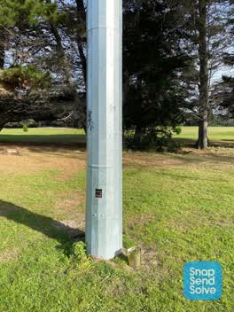 Graffiti —
 Second post from south west side in touch rugby field area
Graffiti —
Also reported on Rawhiti Avenue
- 19 Rawhiti Avenue — 20 reports
- 9 Rawhiti Avenue — 19 reports
- 15 Rawhiti Avenue — 8 reports
- 20 Rawhiti Avenue — 6 reports
- 8 Rawhiti Avenue — 4 reports
- 17 Rawhiti Avenue — 2 reports
- 6A Rawhiti Avenue — 1 report
- 18 Rawhiti Avenue — 1 report
The street’s crash record
NZTA’s record names Rawhiti Avenue in 3 crashes that hurt somebody since 2006 — 1 seriously hurt, nobody killed.
The green nearby
- Rawhiti Domain — you are in it · Sports ground · 61 ha
- North Beach — 95 m to the edge · Regional · 18 ha
- Thomson Park — 201 m to the edge · Sports ground · 2 ha
- New Brighton Beach — 442 m to the edge · Regional · 10 ha
Parks within half a kilometre, measured to the boundary — the council’s open data.
On the doorstep
- The Eastern Hub — 177 m away · Clubs
- Rawhiti Golf Club — 328 m away · Golf courses
Businesses within four hundred metres, measured at the pin — OpenStreetMap and the council directories.
The bus nearby
- Marine Pde near Rawhiti Ave — 122 m away · route 135
- Marine Pde near Rawhiti Ave — 282 m away · route 135
The closest Metro stops, within four hundred and fifty metres.
The tracks through here
- Walk and bike track through New Brighton — 149 m to the line · walk · bike
- Walk and bike track through New Brighton — 278 m to the line · walk · bike
- Walk and bike track through New Brighton — 465 m to the line · walk · bike
Tracks whose line passes within half a kilometre, measured to the line itself — the council’s open data.
The named ground
Named places within 1.5 km of this address; the council’s own structure register — bridges, boardwalks and steps standing nearby — the open map’s record.
Renting nearby
new bonds in New Brighton ran about $520 a week — $30 below the city median of $550 — the suburb page keeps the rent record →.
The civic layer
This ground votes in Coastal ward — the Coastal-Burwood-Linwood community board. Ward lines don’t always follow suburb lines; this one is measured at the pin, not the suburb’s centre.
What stood on this ground → · On the map → · From the air — the Crown’s aerials back to 1936; search the address on RetroLens →
Questions, answered briefly
16 council reports on record since August 2016 — most often graffiti (6), park - general request (3), overgrown vegetation (2).
New Brighton, Christchurch — on Rawhiti Avenue.
Nothing on the heritage register at this exact spot — the record around this ground →
Rawhiti Domain — the address is inside it, 61 ha.