283 Marine Parade, New Brighton
51 reports on record since September 2017 · 34 with photographs. The street’s heaviest record is 213 Marine Parade — 338 reports on file. Indicative rating valuation and school zones, hazards, bin day and what stood here before.
What gets reported here
- Graffiti — 11
- Overgrown Vegetation — 7
- Parks — 6
- Graffiti on a fence, building or structure — 6
- Park - General Request — 3
- Facility - General Request — 3
Photographed here 34 on record


Reported here
 Graffiti on a sign, mural or public art —
 Graffiti on beach access sign at Shackelton St access.
 Park - General Request —
 seats from lookout have been stolen
 Facility - General Request —
 Hand rail is disappearing on beach side of access way but on Marine Parade side it has very little of post left in ground. Looks an eye sore
 Overgrown Vegetation —
 Can you see the beach access? Not easy as it is so over grown. Just about impossible to get a pram over the 'walkway'
 Park - General Request —
 Cyclists on the dune top track almost crash into people. This track is NOT suitable for cyclists. There are very narrow parts wth blind spot
 Graffiti on a fence, building or structure —
 See pic
 Graffiti on a fence, building or structure —
  Pavement - Damaged —
 Dangerous trip hazard
 Overgrown Vegetation —
 Beach access overgrown
 Graffiti on a fence, building or structure —
 Tag on wooden seat beach track on hill
 Graffiti on a fence, building or structure —
  Overgrown Vegetation —
 Beach access neglected and overgrown
 Dumped Rubbish —
 A cart full of cacti??
 Overgrown Vegetation —
  Graffiti on a fence, building or structure —
 Tags on beach seat on top of sand hills
 Graffiti on a fence, building or structure —
  Park - General Request —
 Fence is now broken on both sides. I sent a photo through when it was just one side. Dangerous post point is now exposed.
 Facility - General Request —
 Handrail has been pulled from the ground and is creating a hazard on path from dunes down to the road.
 Facility - General Request —
 The railings on this beach path need to be put back in the ground. Back in the late-90s, these railings were at hip height. They are now com
 Dumped Rubbish —
 Broken stroller on the beach access at Shackleton St
 Dumped Rubbish —
 Rubbish that hasn't been cleared yet moved and added to
 Overgrown Vegetation —
 - Graffiti —
- Graffiti —
- Pavement - Damaged —
- Overgrown Vegetation —
- Overgrown Vegetation —
- Graffiti —
- Pavement - General —
- Poles and Signage - General —
- Graffiti —
- Pavement - General —
- General Request —
- Damaged Street Light —
- Street Light Outage —
- Graffiti —
- Graffiti —
- Graffiti —
- Graffiti —
 Graffiti —
 Tag on seat along beach track on top of sand hill
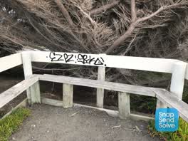 Graffiti —
 Tag on seat top of sand hill
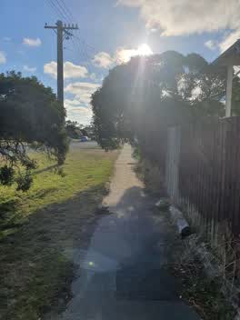 Roading/Streets —
 Overhanging tree at 283 Marine Parade along Shackleton St boundary. Tree has been overhanging, obstructing the footpath, for months. Can you
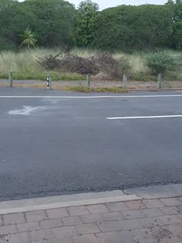 Parks —
 The tenant in 282 Marine Parade has dumped a huge pile of tree cuttings across the road on the Council land (as pictured). They also have a
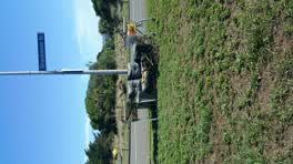 Rubbish/Recycling —
 rubbish dumped on road side
Wastewater/Stormwater —
Seeping pipe, although it's a drink fountain and bird bath it needs fixing
Parks —
This is over grown and a mess
Graffiti —
Parks —
The path is just about over grown
Parks —
This is such a mess, 3rd report I have sent
Parks —
Over grown paths and weeds
Parks —
Weeds over grown along track all the way
Also reported on Marine Parade
- 213 Marine Parade — 338 reports
- 195 Marine Parade — 171 reports
- 198 Marine Parade — 140 reports
- 144/91 Marine Parade — 109 reports
- 93 Marine Parade — 85 reports
- 225 Marine Parade — 78 reports
- 269 Marine Parade — 56 reports
- 142 Marine Parade — 50 reports
The street’s crash record
NZTA’s record names Marine Parade in 33 crashes that hurt somebody since 2006 — 2 people killed, 11 seriously hurt.
The green nearby
- New Brighton Beach — 21 m to the edge · Regional · 10 ha
- Withells Island Reserve — 370 m to the edge · 4 ha
- Blighs Garden — 405 m to the edge · 6 ha
Parks within half a kilometre, measured to the boundary — the council’s open data.
On the doorstep
- Ruelle Eatery — 209 m away · Cafés
- South Brighton Surf Life Saving Club — 334 m away · Clubs
Businesses within four hundred metres, measured at the pin — OpenStreetMap and the council directories.
The bus nearby
The closest Metro stops, within four hundred and fifty metres.
The named ground
Named places within 1.5 km of this address; the council’s own structure register — bridges, boardwalks and steps standing nearby — the open map’s record.
Renting nearby
new bonds in New Brighton ran about $520 a week — $30 below the city median of $550 — the suburb page keeps the rent record →.
The civic layer
This ground votes in Coastal ward — the Coastal-Burwood-Linwood community board. Ward lines don’t always follow suburb lines; this one is measured at the pin, not the suburb’s centre.
What stood on this ground → · On the map → · From the air — the Crown’s aerials back to 1936; search the address on RetroLens →
Questions, answered briefly
51 council reports on record since September 2017 — most often graffiti (11), overgrown vegetation (7), parks (6).
New Brighton, Christchurch — on Marine Parade.
Nothing on the heritage register at this exact spot — the record around this ground →
New Brighton Beach — 21 m to its edge, 10 ha.