Rimu Park
2 ha
From the air
Where it sits
Its centre falls inside Templeton, suburb membership is a centroid call, not a claim the whole park lies inside the outline.
More green in Templeton
- Ruapuna Park, Sports ground · 53 ha
- Hasketts Reserve · 4 ha
- Chattertons Reserve · 4 ha
- Globe Bay Reserve · 3 ha
- Templeton Domain, Sports ground · 3 ha
- Jones Reserve, Sports ground · 2 ha
- Kirk Reserve · 2 ha
- Railway Reserve
What’s built on this ground
A playground stands here, the register counts 0 pieces of play equipment on a marked playground ground.
No site tag names this park, these are the register’s pins inside its drawn outline (or within 250 m of its centre), a surveyor’s point, not a boundary.
The reports on this ground
2 reports pinned inside the park's drawn outline, most often Trees & parks and Roads & footpaths, 2 with a photograph. A pin is where a reporter stood, not a claim about the whole park.
 Accessibility, Rimu Scout Park, Rimu Park 581-611 Buchanans Road, Templeton, Christchurch 7676, New Zealand · 15 December 2023
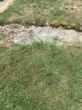 Parks, 545, Buchanan's Road, Templeton, Canterbury, 7676, New Zealand · 12 January 2021
Environment Canterbury / Canterbury Maps, Parks layer · refreshed 10 October 2026.
What stood on this ground before → · On the map →
Questions, answered briefly
2 hectares by the layer’s own polygon.
Its centre falls inside Templeton, a centroid call, not a claim the whole park lies inside the outline.
A park or reserve.
Environment Canterbury’s open Parks layer, kind, size and suburb read straight from it.