15 Putake Drive
12 council reports since April 2025, 12 carrying a photograph. The most-reported address on Putake Drive.
From the air, then
Sourced from Canterbury Maps and partners. LINZ, CC BY 3.0 NZ. Each frame is cut from Environment Canterbury’s historic imagery MapServer for that decade, only where the Footprints layer names a CC BY survey (NZAM-covered spots stay out). RetroLens holds more Crown aerials →
The green nearby
- Putake Reserve, 25 m to the edge · 2 ha
- Titirangi Reserve, 195 m to the edge · 2 ha · playground, 28 pieces
- Travis Wetland, 196 m to the edge · Regional · 122 ha
- Pohutukawa Reserve, 343 m to the edge
- Rothesay Reserve, 419 m to the edge · 3 ha
Parks within half a kilometre, measured to the boundary, the council’s open data. The whole roll is at /parks.
On the doorstep
- Wetlands Eatery, 259 m away · Cafés
- The Magnolia Cafe, 260 m away · Cafés
- Bella Donna Beauty, 261 m away · Beauty
- Unichem, 267 m away · Pharmacies
Businesses within four hundred metres, measured at the pin, OpenStreetMap and the council directories.
The bus nearby
- Mairehau Rd near Putake Dr, 290 m away · route 7, route 135
- Mairehau Rd near Putake Dr, 328 m away · route 7, route 135
The closest Metro stops, within four hundred and fifty metres.
The tracks through here
- Walk and bike track through Parklands, 188 m to the line · walk · bike
- Walk and bike track through Parklands, 407 m to the line · walk · bike
Tracks whose line passes within half a kilometre, the council’s open data.
The named ground
Named places within 1.5 km of this address; the council’s own structure register, bridges, boardwalks and steps standing nearby, the open map’s record.
Renting nearby
new bonds in Parklands ran about $579 a week, $29 above the city median of $550, the suburb page keeps the rent record →.
What gets reported here
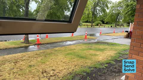
Photographed here 12 on record




What’s on record
 Roads - General, 15 Sept 2026
 This section of road recently had the gutter replaced and has been resealed. However the edge between the new and old seal does not have a c
 Damaged Road, 6 Sept 2026
 Our curb was recently ‘fixed’ due to slumping of the road and pooling water when it rained. Duringthe ‘fixing’ of this issue HEB contractors
 Damaged Road, 25 Jun 2026
 Pooling as per rain. It is a hazard to get in and out. It begins to smell like the poo pond/bromley as it is stagnant water.
 Accessibility, 25 Jun 2026
 Pooling water. When rains you can’t access house safely.
 Pavement - Damaged, 22 Dec 2025
 Recently ‘fixed’ path. It needs to be properly dug out and replaced. What’s underneath is growing up.
 Accessibility, 22 Dec 2025
 Water pools at end of driveway. Due to the trees. Please fix it as it is an accessibility issue anytime it rains. This is shown by the water
 Pavement - Damaged, 17 Dec 2025
 Water continues to pool every time it rains. It is not a flooding issue. It is a poorly ‘fixed’ concrete issue. Cut the tree down, remove th
 Pavement - Damaged, 14 Dec 2025
 The path was just relaid due to roots under the path growing and building it up. They didn’t dig out the issue so the roots have grown alrea
 Street Gutters / Storm Water, 13 Nov 2025
 Water still pooling! They are doing paths but we have been advised by the person who came to look that tithe trees need cutting down and new
 Flooding, 13 Nov 2025
 They have cut open the path but this isn’t going to fix the water pooling. ???!! Further Proof of water pooling and the pooling on path too
 Pavement - Damaged, 23 Apr 2025
 Trip hazard on the path. A few people have tripped/stumped over it
 Street Gutters / Storm Water, 17 Apr 2025
 Water pools at the end of the driveway of 15 Putake Drive. It doesn’t funnel to the drain
Elsewhere on Putake Drive
- 59 Putake Drive, 9 reports
- 1 Putake Drive, 7 reports
- 39 Putake Drive, 6 reports
- 7 Putake Drive, 3 reports
- 53 Putake Drive, 3 reports
- 48 Putake Drive, 3 reports
- 25 Putake Drive, 3 reports
- 77 Putake Drive, 2 reports
The street’s crash record
NZTA’s record names Putake Drive in 8 crashes that hurt somebody since 2006, 1 seriously hurt, nobody killed.
The civic layer
This ground votes in Coastal ward, the Coastal-Burwood-Linwood community board is its local layer. Ward lines don’t always follow suburb lines; this one is measured at the pin, not the suburb’s centre. The whole roll is at /wards.
Putake Drive, the whole record → · Everything about Parklands → · What stood on this ground → · On the map → · From the air, RetroLens holds the Crown’s aerials back to 1936; search the address there →
Questions, answered briefly
12 council reports on record since April 2025, most often pavement - damaged (4), street gutters / storm water (2), damaged road (2).
Parklands, Christchurch, on Putake Drive.
Nothing on the heritage register at this exact spot, the record around this ground →
Putake Reserve, 25 m to its edge, 2 ha.