2 Penwood Street
11 council reports since January 2018, 9 carrying a photograph. The most-reported address on Penwood Street.
From the air, then
Sourced from Canterbury Maps and partners. LINZ, CC BY 3.0 NZ. Each frame is cut from Environment Canterbury’s historic imagery MapServer for that decade, only where the Footprints layer names a CC BY survey (NZAM-covered spots stay out). RetroLens holds more Crown aerials →
The green nearby
- Pinehurst Reserve, 3 m to the edge · playground, 5 pieces
- Calbreath Reserve, 308 m to the edge · playground, 17 pieces
- Karnak Reserve, 438 m to the edge
- Crosbie Park, 456 m to the edge · Sports ground · 7 ha · playground, 76 pieces
- Avonhead Park, 461 m to the edge · Sports ground · 23 ha
Parks within half a kilometre, measured to the boundary, the council’s open data. The whole roll is at /parks.
On the doorstep
- Plunket, 45 m away · Centre
- Pioneers Cafe - Russley Road, 284 m away · Restaurants
- Passengers + Co, 287 m away · Cafés
- Ryman Healthcare Christchurch, 293 m away · Company
Businesses within four hundred metres, measured at the pin, OpenStreetMap and the council directories.
The bus nearby
- Bentley St near Pinehurst Cres, 222 m away · route 125, route 140
- Russley, 227 m away · route 125, route 140
The closest Metro stops, within four hundred and fifty metres.
The named ground
the council’s own structure register, bridges, boardwalks and steps standing nearby, the open map’s record.
What gets reported here
- Pavement - Damaged, 3
- Street Gutters / Storm Water, 2
- Roading/Streets, 2
- Water Leak, 1
- Park - General Request, 1
- General Request, 1
Photographed here 9 on record


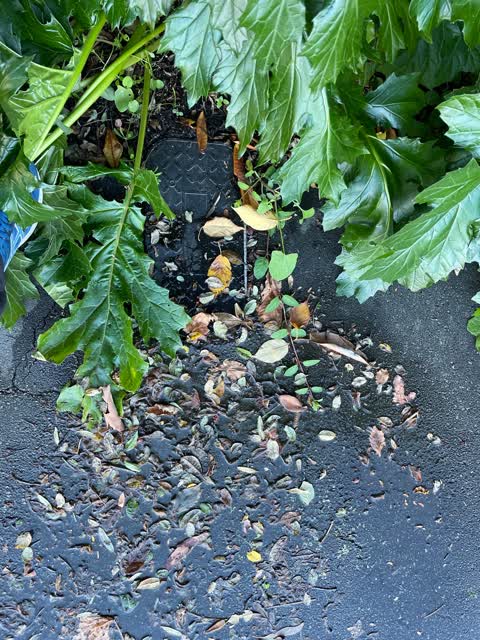
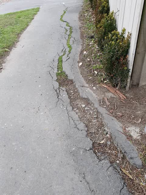

What’s on record
 Pavement - Damaged, 12 Feb 2026
The foot path is littered with bird poop from the eucalyptus tree above. I regards this as a health and safety issue as this footpath has a
 Park - General Request, 12 Feb 2026
 General Request, 18 Jun 2025
The branch is touching our power line
 Pavement - Damaged, 2 Feb 2024
I did SSS ID2852921 29 Nov 2022 regarding this problem. I never got a response. The pavement has gone worst. The roots from the eucalyptus t
 Street Gutters / Storm Water, 9 Jan 2024
I did a snap send and solve end of Dec 2023 ref #4081084. The water is now a green colour and it smells.
 Street Gutters / Storm Water, 31 Dec 2023
There is a water leakage from the gutter outlet to the roadside gutter. There has NOT been any rain and there is water. Would like somebody
- Fallen Tree, 6 Feb 2023
- Pavement - Damaged, 29 Nov 2022
 Water Leak, 23 Apr 2022
At 3 Penwood Street, Russley, Christchurch
 Roading/Streets, 1 Aug 2020
This incident is actually on the corner on the edge of the reserve with the big tree and the tree roots are making the footpath dangerous, r
Roading/Streets, 17 Jan 2018
For parking enforcement, the pictured vehicle is parked in the opposite direction for that side of the road.
Elsewhere on Penwood Street
- 5 Penwood Street, 6 reports
- 8 Penwood Street, 5 reports
- 3 Penwood Street, 5 reports
- 22 Penwood Street, 5 reports
- 1 Penwood Street, 4 reports
- 7 Penwood Street, 3 reports
- 2A Penwood Street, 2 reports
- 10 Penwood Street, 2 reports
The civic layer
This ground votes in Waimairi ward, the Fendalton-Waimairi-Harewood community board is its local layer. Ward lines don’t always follow suburb lines; this one is measured at the pin, not the suburb’s centre. The whole roll is at /wards.
Penwood Street, the whole record → · Everything about Russley → · What stood on this ground → · On the map → · From the air, RetroLens holds the Crown’s aerials back to 1936; search the address there →
Questions, answered briefly
11 council reports on record since January 2018, most often pavement - damaged (3), street gutters / storm water (2), roading/streets (2).
Russley, Christchurch, on Penwood Street.
Nothing on the heritage register at this exact spot, the record around this ground →
Pinehurst Reserve, 3 m to its edge.