TKKM o Te Whanau Tahi
Composite · State · Spreydon, Christchurch
234 students on the roll in Spreydon · EQI 494.
Its rating
Final decile (2022): 3. Current Equity Index: 494. Decile and EQI describe the community a school draws its students from — they say nothing about how well it teaches.
The record
- 83 Lyttelton Street, Spreydon, Christchurch, 8244 — the street’s record
- Its suburb: Spreydon — the suburb’s own record
- Roll: 234 (September 2026)
- Co-Educational
- Donations should not be requested, unless for a school camp
- Opened 1997
- Isolation index 0.15 — the Ministry’s remoteness measure; higher is more remote
- Instruction: All students taught in te reo Māori
- Phone: 03-3374360
- Email: mahanui@whanau-tahi.school.nz
- Contact: Hayley May
- Website: whanau-tahi.school.nz
Who the roll is
Students may identify with more than one group — the counts are the Ministry’s own and need not sum to the roll.
Other schools near here
 Our Lady of the Assumption School (Chch) — decile 10 · EQI 401 · 606 m
- Te Ara Koropiko West Spreydon School — decile 4 · EQI 445 · 612 m
- Hoon Hay Te Kura Kōaka — decile 8 · EQI 416 · 645 m
 Cashmere High School — decile 9 · EQI 413 · 747 m
- Somerfield Te Kura Wairepo — decile 8 · EQI 419 · 1.2 km
 Te Kura o Mōkihi Spreydon School — decile 3 · EQI 453 · 1.6 km
 Christchurch South Karamata Intermediate School — decile 8 · EQI 411 · 1.6 km
- Te Kura o Huriawa Thorrington — decile 10 · EQI 377 · 1.8 km
The green nearby
Parks whose drawn outline sits within 400 m — measured to the outline itself, so a school on a big reserve’s edge still counts.
- Centennial Park — Sports ground · 30 m to its edge
- Hoon Hay Scouts Reserve · 254 m to its edge
Facilities nearby
Council facilities within 400 m of the school’s point — libraries, pools and centres a parent can walk to.
- Pioneer — Recreation centre · 143 m
The bus stop
The nearest stop the Metro map carries — measured to the school’s pin, not its gate.
- Lyttelton St near Conway St — 115 m · route Oa
The reports nearby
9 reports pinned within 250 m of the school’s point — most often Roads & footpaths and Water & drains, 5 with a photograph. A pin is where a reporter stood, not a claim about the school.
 Water Leak — 108E Lyttelton Street, Spreydon, Christchurch 8024, New Zealand · 7 June 2026
- Damaged Road — 99 Lyttelton Street, Spreydon, Christchurch, New Zealand · 2 May 2024
- Graffiti — 102 Lyttelton Street, Somerfield, Christchurch 8024, New Zealand · 21 May 2023
- Water Leak — 106 Lyttelton Street, Spreydon, Christchurch 8024, New Zealand · 13 October 2022
- Water Leak — 108 Lyttelton Street, Spreydon, Christchurch 8024, New Zealand · 8 October 2022
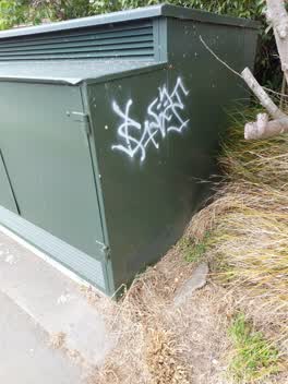 Graffiti — 103 Lyttelton Street, Canterbury 8024, New Zealand · 2 November 2021
Rubbish/Recycling — 102 Lyttelton St, Somerfield, Christchurch 8024, New Zealand · 9 August 2019
Roading/Streets — 97 Lyttelton St, Somerfield, Christchurch 8024, New Zealand · 30 May 2018
Roading/Streets — 90, Lyttelton Street, Spreydon, 8024, Canterbury · 11 May 2016
Under the ground
The plans and surveys the site keeps, asked once of the school’s ground — footprints and plan maps, not engineering findings.
- On a council-listed parcel — Cemeteries and waste recycling, treatment and disposal
- On made ground — Mixed Fill with Rubbish
- The liquefaction model grades it “Medium Liquefaction Vulnerability” — the 2019 screening study
Ministry of Education school directory via data.govt.nz · zones via the Ministry’s enrolment-zone map · refreshed 3 October 2026.
What stood on this ground before → · On the map →
Questions, answered briefly
Composite · State · Co-Educational — in Spreydon.
234 on the roll at September 2026 — the Ministry of Education’s count.
EQI 494 — its final decile (2022, before the EQI replaced it) was 3.
Centennial Park, Hoon Hay Scouts Reserve — green space within 400 m of the school’s point.