150 Selwyn Street, Somerfield
17 reports on record since July 2017 · 16 with photographs. The most-reported address on Selwyn Street. Indicative rating valuation and school zones, hazards, bin day and what stood here before.
What gets reported here
- Overgrown Vegetation — 3
- Hazard — vehicle — 3
- Graffiti — 3
- Graffiti somewhere else — 2
- Roading/Streets — 1
- Pothole — 1
Photographed here 16 on record




Reported here
 Pothole —
 Large and small pothole
 Hazard — vehicle —
 Illegal parking on grass berm
 Overgrown Vegetation —
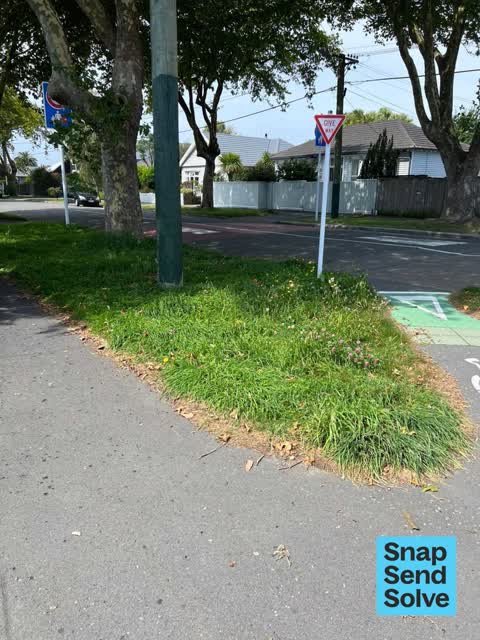
 This council house needs its lawn mown inside the section and on the berm outside. Constant issue - needs to be done regularly as the person
 Overgrown Vegetation —
 This council house and the one next to it needs its lawn mown inside the and outside of the fences - I think the people living in these coun
 Graffiti somewhere else —
 Graffiti on the island at the intersection of Roker and Selwyn Streets
 Hazard — vehicle —
  Hazard — vehicle —
  Graffiti somewhere else —
 Graffiti on the island - Selwyn St and Roker St intersection
 Overgrown Vegetation —
 The x2 council houses on corner of Selwyn Street and Roker Street are extremely overgrown and are not being cared for at all - this looks te
 Graffiti on a cabinet, pole or railway asset —
 Black and blue paint tags on FC860 Orion pole by 150 Selwyn Street corner of Roker Street.
 Graffiti on a sign, mural or public art —
 Black paint tag on Give Way sign at the corner of Roker and Selwyn Streets.
 Dumped Rubbish —
 Bag of ??? Dumped on the verge outside 150 Selwyn Street needs removal.
- Pavement - General —
Graffiti —
back of signs on cross walk Selwyn at Roker, 3 places
Graffiti —
back of signs on cross walk Selwyn at Roker, 3 places
Graffiti —
On cycle give way sign
Roading/Streets —
Former bus stop, yellow markings still on the road preventing parking. Parking is in short supply here due to nearby shops.
Also reported on Selwyn Street
- 171 Selwyn Street — 15 reports
- 169 Selwyn Street — 9 reports
- 56 Selwyn Street — 8 reports
- 29 Selwyn Street — 8 reports
- 177 Selwyn Street — 7 reports
- 69 Selwyn Street — 6 reports
- 83 Selwyn Street — 5 reports
- 16 Selwyn Street — 5 reports
The street’s crash record
NZTA’s record names Selwyn Street in 34 crashes that hurt somebody since 2006 — 8 seriously hurt, nobody killed.
The green nearby
- Somerfield Park — 315 m to the edge · Sports ground · 3 ha
- Bradford Park — 371 m to the edge · Sports ground · 3 ha
- Cheviot Reserve — 401 m to the edge
Parks within half a kilometre, measured to the boundary — the council’s open data.
The civic shelf nearby
- Sydenham Cemetery — 241 m away · Cemetery
Libraries, halls and the rest within half a kilometre — the council’s open data.
On the doorstep
- Milton Street Dairy — 83 m away · Dairies & convenience
- Challenge — 140 m away · Petrol stations
- Riccarton Players — 383 m away · Cinemas & theatres
Businesses within four hundred metres, measured at the pin — OpenStreetMap and the council directories.
The bus nearby
The closest Metro stops, within four hundred and fifty metres.
The tracks through here
- Walk and bike track through Somerfield — 104 m to the line · walk · bike
- Walk and bike track through Somerfield — 363 m to the line · walk · bike
- Walk and bike track through Somerfield — 381 m to the line · walk · bike
- Walk and bike track through Somerfield — 402 m to the line · walk · bike
- Walk and bike track through Somerfield — 404 m to the line · walk · bike
Tracks whose line passes within half a kilometre, measured to the line itself — the council’s open data.
Renting nearby
new bonds in Somerfield ran about $567 a week — $17 above the city median of $550 — the suburb page keeps the rent record →.
The civic layer
This ground votes in Cashmere ward — the Spreydon-Cashmere-Heathcote community board. Ward lines don’t always follow suburb lines; this one is measured at the pin, not the suburb’s centre.
What stood on this ground → · On the map → · From the air — the Crown’s aerials back to 1936; search the address on RetroLens →
Questions, answered briefly
17 council reports on record since July 2017 — most often overgrown vegetation (3), hazard — vehicle (3), graffiti (3).
Somerfield, Christchurch — on Selwyn Street.
Nothing on the heritage register at this exact spot — the record around this ground →
Somerfield Park — 315 m to its edge, 3 ha.