150 Heyders Road, Spencerville
25 reports on record since June 2021 · 15 with photographs. The most-reported address on Heyders Road. Indicative rating valuation and school zones, hazards, bin day and what stood here before.
What gets reported here
- Rubbish and Bins - General, 5
- Facility - General Request, 4
- Dumped Rubbish, 3
- Litter, 2
- Trees - General, 1
- Road Blockage, 1
Photographed here 15 on record


Reported here
 Dumped Rubbish,
 Rubbish dumping with recycling medicines, food, and other assorted rubbish. Was a few sharp blades from an exacto knife that we moved so d
 Trees - General,
 This tree seems to be leaning much more than I remember. can the Rangers check it out to see if they agree.
 Damaged Asset – CCC contractor,
 Found during survey in water loss zone BK1. Hydrant bowl is passing. Managed to get a half turn on it to tighten up. But it's still got
 Road Blockage,
 A pine tree has broken a huge branch that is now blocking the path which goes from the surf club to Spencer Park
 Facility - General Request,
 Some damage at Spencer Park Beach entrance track. Council Beach safety sign post has fallen over or been pulled out. Maybe due to recent sto
- Dumped Rubbish,
A large amount of household rubbish has been dumped in the beach car park at spencer beach
 Hazard, vehicle,
 Out on Spencerville beach with a Scouts group. This ute overloaded with people came and did doughnuts infront of our Group. They then got st
 Facility - General Request,
 The lockable gate to the beach has been damaged by a vehicle colliding with it. There used to be several more padlocks on it so maybe the dr
 Facility - General Request,
 Spencer Park Beach at the end of Heyders Road Carpark. The recent wave erosion of the shore has uprooted the rubbish bin the beach sign post
- Rubbish and Bins - General,
Bin fallen over
 Dumped Rubbish,
 Old bicycles and tyres
 Rubbish and Bins - General,
 Overflowing rubbish and bins washed up from beach
 Abandoned Vehicle,
 Dumped car? Parked in middle of exit loop road at the end of Heyders rd
 Facility - General Request,
 Broken glass in car park
 Graffiti on a sign, mural or public art,
 Someone has painted the male sign into a women’s sign and then the women’s sign has some tit’s graffitied on it.
- Litter,
- Litter,
- General Request,
- Animal - Deceased,
- Park - General Request,
- Rubbish and Bins - General,
- Rubbish and Bins - General,
- Rubbish and Bins - General,
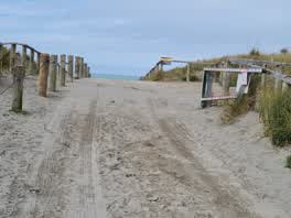 Parks,
 Chain locking Spencer park beach access gate is missing
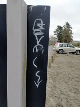 Graffiti,
 REMOVED BY VOLUNTEER
Also reported on Heyders Road
- 6A Heyders Road, 9 reports
- 13 Heyders Road, 9 reports
- 110 Heyders Road, 9 reports
- 115 Heyders Road, 8 reports
- 67 Heyders Road, 5 reports
- 18 Heyders Road, 5 reports
- 24 Heyders Road, 3 reports
- 2 Heyders Road, 3 reports
The street’s crash record
NZTA’s record names Heyders Road in 1 crash that hurt somebody since 2006, 0 seriously hurt, nobody killed.
The green nearby
- Spencer Park Beach, you are in it · Regional · 11 ha
- Spencer Park, 105 m to the edge · Regional · 47 ha
Parks within half a kilometre, measured to the boundary, the council’s open data.
The named ground
Named water within 500 m of this address, measured to the line or the edge; Named places within 1.5 km of this address; the council’s own structure register, bridges, boardwalks and steps standing nearby, the open map’s record.
The civic layer
This ground votes in Coastal ward, the Coastal-Burwood-Linwood community board. Ward lines don’t always follow suburb lines; this one is measured at the pin, not the suburb’s centre.
What stood on this ground → · On the map → · From the air, the Crown’s aerials back to 1936; search the address on RetroLens →
Questions, answered briefly
25 council reports on record since June 2021, most often rubbish and bins - general (5), facility - general request (4), dumped rubbish (3).
Spencerville, Christchurch, on Heyders Road.
Nothing on the heritage register at this exact spot, the record around this ground →
Spencer Park Beach, the address is inside it, 11 ha.