450 Barrington Street, Spreydon
29 reports on record since May 2017 · 19 with photographs. The street’s heaviest record is 266 Barrington Street — 194 reports on file. Indicative rating valuation and school zones, hazards, bin day and what stood here before.
What gets reported here
- Roading/Streets — 5
- Road Signage — 4
- Graffiti — 4
- Dumped Rubbish — 3
- Parks — 2
- Fallen Tree — 2
Photographed here 19 on record


Reported here
- Road Signage —
street road work sign causes a hazard at beginning of cycle lane on Barrington st. Either from an old road work and forgot to collect or you
 Graffiti on a road, footpath or bridge —
 Graffiti on the underside of the overpass between Jerrold Streets North and South.
 Litter —
 Broken glass bottles on cycle path next to eastern/southern side intersection of Barrington St glass is covering the whole cycleway
 Street Cleaning —
 Smashed glass bottle across the cycleway
 Dumped Rubbish —
 Rubbish dumped on the verge
 Road Signage —
 Orange signs warning of Men at Work and Works End have been on Barrington Street for well over a mile both with no work having been evident.
 Road Signage —
 It seems that these signs have been forgotten. Job completed long time ago
 Traffic Signals —
 He yellow light isn’t working on the traffic light. For traffic going straight through and then under the bridge. NOT FOR TRAFFIC GOING ON T
 Road Signage —
 There is a lack of road markings on Barrington St as you come under highway 76 heading south. Two lanes can head straight through the traffi
 General Request —
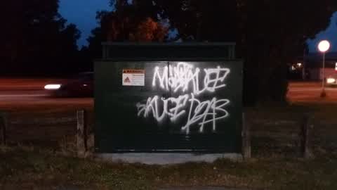
 Graffiti on an Orion electric box in front of 438 Barrington Street.
 Fallen Tree —
 This fallen tree came down ages ago and I've been meaning to report it for removal but keep forgetting. It's at the end of Barrington Stree
 Fallen Tree —
 Fallen dead tree
- Facility - General Request —
- Dumped Rubbish —
- Park - General Request —
- Graffiti —
- Hazard — vehicle —
- Graffiti —
- Dumped Rubbish —
In little park by bridge. Infront of tree that has undergrowth.
Graffiti —
Orion box
Graffiti —
Roading/Streets —
in left lane heading north. looks as if we collapse in soon.
Roading/Streets —
There is a car parked outside 450 Barrington st on the berm and on the reserve beside every day. I have reported this several times but noth
Parks —
This is one of several cars that is parked on the reserve daily.
Roading/Streets —
The grass reserve beside 450 Barrington st is used as a car park almost every day.
Roading/Streets —
There are cars parked on the reserve almost every weekend and sometimes overnight (today Tues 5 Feb). There was another car parked on the g
Wastewater/Stormwater —
Looks like a watermain has burst outside 463 Barrington Street. This is a duplicate report. The original report was sent on 11/01/2019.
- Parks —
The residents at this property have been using the grass verge for quite some time as is evident from the degraded condition of the ground.
- Roading/Streets —
Traffic lights for cyclists heading east don't work for me. Yesterday they stayed red through a full cycle. Today the light on the post di
Also reported on Barrington Street
- 266 Barrington Street — 194 reports
- 256 Barrington Street — 22 reports
- 270 Barrington Street — 16 reports
- 290 Barrington Street — 15 reports
- 461 Barrington Street — 14 reports
- 377 Barrington Street — 10 reports
- 340 Barrington Street — 9 reports
- 275A Barrington Street — 9 reports
The street’s crash record
NZTA’s record names Barrington Street in 72 crashes that hurt somebody since 2006 — 18 seriously hurt, nobody killed.
The green nearby
- Addington Park — 153 m to the edge · Sports ground · 3 ha
- Leith Reserve — 278 m to the edge
- Parade Court Reserve — 391 m to the edge
- Jerrold Reserve — 427 m to the edge
Parks within half a kilometre, measured to the boundary — the council’s open data.
On the doorstep
- Addington Motel Raceway — 320 m away · Motels
- Raceway Motel — 328 m away · Motels
- Z — 364 m away · Petrol stations
- Z2O — 368 m away · Car washes
Businesses within four hundred metres, measured at the pin — OpenStreetMap and the council directories.
The bus nearby
- Barrington St near Hammond Pl — 192 m away · the Orbiter (clockwise)
- Barrington St near Neville St — 220 m away · the Orbiter (anticlockwise)
The closest Metro stops, within four hundred and fifty metres.
The tracks through here
- Walk and bike track through Spreydon — 11 m to the line · walk · bike
- Walk and bike track through Spreydon — 268 m to the line · walk · bike
- Walk and bike track through Spreydon — 374 m to the line · walk · bike
- Walk and bike track through Spreydon — 411 m to the line · walk · bike
Tracks whose line passes within half a kilometre, measured to the line itself — the council’s open data.
The named ground
Named water within 500 m of this address, measured to the line or the edge; Named places within 1.5 km of this address — the open map’s record.
Renting nearby
new bonds in Spreydon ran about $555 a week — about the city median — the suburb page keeps the rent record →.
The civic layer
This ground votes in Spreydon ward — the Spreydon-Cashmere-Heathcote community board. Ward lines don’t always follow suburb lines; this one is measured at the pin, not the suburb’s centre.
What stood on this ground → · On the map → · From the air — the Crown’s aerials back to 1936; search the address on RetroLens →
Questions, answered briefly
29 council reports on record since May 2017 — most often roading/streets (5), road signage (4), graffiti (4).
Spreydon, Christchurch — on Barrington Street.
Nothing on the heritage register at this exact spot — the record around this ground →
Addington Park — 153 m to its edge, 3 ha.