River Road
14 reports at 2 addresses in Avonside, the first in 2019, the latest 2025. 11 separate days somebody filed something about it.
Where it runs
Each report dot is the average of the spots reports were filed from, where reporters stood on River Road, not the street’s surveyed line. The strong outline is Avonside.
From the air, then
Sourced from Canterbury Maps and partners. LINZ, CC BY 3.0 NZ. Each frame is cut from Environment Canterbury’s historic imagery MapServer for that decade, only where the Footprints layer names a CC BY survey (NZAM-covered spots stay out). RetroLens holds more Crown aerials →
The addresses on it
- 154 River Road, 9 reports
- 171 River Road, 5 reports
What got reported
- Rubbish & dumping, 12 reports
- Water & drains, 1 report
- Roads & footpaths, 1 report
Year by year
- 2019, 2 reports
- 2023, 1 report
- 2024, 7 reports
- 2025, 4 reports
In the written record
Archive documents carrying the street’s name: leads and citations, not verified history. 327 on the shelf; the 11 earliest:
- RURAL SECTIONS CHOSEN. (Lyttelton Times, 01 March 1851)
· Papers Past,
…sencl 50 acre section in the christchurch district commencing at a point on the heathcote-river road south bank 32 chains south-west of trigonometrical station no 14 back south 47j chains then west 12…
- RURAL SECTIONS-CHOSEN. (Lyttelton Times, 08 March 1851)
· Papers Past,
…of the river and the christchurch and lyttelton road 12j chains frontage to the heathcote river road then 40 chains north-west then north-east 1140 links to the lyttelton and christchurch road 1 chain…
- RURAL SECTIONS CHOSEN. (Lyttelton Times, 15 March 1851)
· Papers Past,
…hristchurch district commencing at the south-east corner of section no 33 frontage to the river road 26 chains thence north 39 chains thence west 25 chains and back to starting point at right angles 4…
- RURAL SECTIONS CHOSEN. (Lyttelton Times, 22 March 1851)
· Papers Past,
…long the river heathcote right bank at the south-east point of no 16 thence following the river road southerly for 15 chains thence eastward along an accommodation road 36 chains to the river heathcot…
- RURAL SECTIONS CHOSEN. (Lyttelton Times, 29 March 1851)
· Papers Past,
…at the south-west corner of the road west of sect 48 12s chains frontage to the heathcote river road north bank back in a north-west direction 40 chains 12 chains wide at the back and numbered 71 on t…
- RURAL SECTIONS CHOSEN. (Lyttelton Times, 19 April 1851)
· Papers Past,
…pa commencing 50 links from the south west corner of section no 83 following the waimairi river road 38 chains then in a north easterly direction 43 chains then at a right angle 25 chains and from the…
- RURAL SECTIONS CHOSEN. (Lyttelton Times, 26 April 1851)
· Papers Past,
…y fitzgerald 50 acres in the christchurch district commencing at a point on the heathcote river road about 71 chains west of trig station no 14 following the course of the said river road to a point 9…
- RURAL SECTIONS CHOSEN. (Lyttelton Times, 03 May 1851)
· Papers Past,
…the said road in a south-west direction 47 chains then at a right angle to the heathcote river road thence following the said road to the northwest corner of section 123 and then following the bounda…
- Page 2 Advertisements Column 2 (Lyttelton Times, 07 August 1852)
· Papers Past,
…0 acres fronting the horse shoe bend of the river heathcote no 87 fifty acres on the avon river road i no 99 fifty acres on the north side of the lyttelton and christchurch road no 101 fifty acres in…
- Page 2 Advertisements Column 1 (Lyttelton Times, 14 August 1852)
· Papers Past,
…0 acres fronting the horse shoe bend of the river heathcote no 87 fifty acres on the avon river road no 99 fifty acres on the north side of the lyttelton and christchurch road no 101 fifty acres in th…
- Page 2 Advertisements Column 1 (Lyttelton Times, 28 August 1852)
· Papers Past,
…0 acres fronting the horse shoe bend of the river heathcote no 87 fifty acres on the avon river road no 99 fifty acres on the north side of the lyttelton and christchurch road no 101 fifty acres in th…
The rest are a search away, the whole shelf, for the name →
The named ground
Named water within 150 m of a reported pin, measured to the line or the edge; the council’s own structure register, bridges, boardwalks and steps standing nearby, the open map’s record.
As it was reported


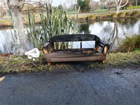
The latest on it
- Dumped Rubbish, 171 River Road,
- Dumped Rubbish, 171 River Road,
- Dumped Rubbish, 154 River Road,
- Dumped Rubbish, 171 River Road,
- Dumped Rubbish, 154 River Road,
- Dumped Rubbish, 154 River Road,
- Dumped Rubbish, 154 River Road,
- Pavement - General, 154 River Road,
- Dumped Rubbish, 154 River Road,
- Dumped Rubbish, 154 River Road,
- Rubbish and Bins - General, 171 River Road,
- Dumped Rubbish, 171 River Road,
- Rubbish/Recycling, 154 River Rd,
- Water Supply, 154 River Rd,
Questions, answered briefly
In Avonside, Christchurch, New Zealand.
14 reports at 2 addresses, most often rubbish & dumping (12), water & drains (1), roads & footpaths (1).
2019, the record covers 11 separate days somebody filed something about it, through 2025.
Every street the archive knows → · Avonside → · This street as a feed →