Waipara Street
1 council report at 1 address on Waipara Street, Hoon Hay, on record since June 2022.
Where it runs
Each report dot is the average of the spots reports were filed from, where reporters stood on Waipara Street, not the street’s surveyed line. The strong outline is Hoon Hay.
From the air, then
Sourced from Canterbury Maps and partners. LINZ, CC BY 3.0 NZ. Each frame is cut from Environment Canterbury’s historic imagery MapServer for that decade, only where the Footprints layer names a CC BY survey (NZAM-covered spots stay out). RetroLens holds more Crown aerials →
The numbered spots
- 26 Waipara Street, 1 report
What got reported
- Rubbish & dumping, 1 report
Year by year
- 2022, 1 report
Documents that name it
Records on the shelf that name Waipara Street.
- JURY LIST. (Lyttelton Times, 31 March 1855) · Papers Past ·
…laborer brown john thomas gloucester street christchurch stockowner brown charles hunter waipara station stock owner brown henry s forncett farm farmer brown charles ohrjstchurch sawyer brown john su…
- JURY LIST. (Lyttelton Times, 04 April 1855) · Papers Past ·
…exeter street lyttelton gentleman ward john henry mandeville district farmer ward charles waipara station laborer ward edward goodrich motunau dairyman ware thomas okain bay sawyer washbourn henry joh…
- Page 3 Advertisements Column 2 (Lyttelton Times, 30 April 1856) · Papers Past ·
…ge for sale at he fjeubtwharp 40 tons of english coals apply to the wliai finger fob sale waipara station double corner this well known station commands the run of 35000 acres of first rate country on…
- Untitled (Grey River Argus, 17 April 1872) · Papers Past ·
…turday a riinaway debtor was brought up to bedealt with he had been arrested on board thl waipara steamer at hokitika and-rpaid some of hir creditors but others had been almost as sharp whom he was un…
- COLONIAL REINFORCEMENTS. (Star, 06 February 1902) · Papers Past ·
…com inveroarcill stephenson thomas labourer christchuroh symoads benjamin lewis farm hand waipara stringer edric harold station 1 linwood tall benjamin thomass farrifw alexandra turner william shepher…
The rest are a search away, the whole shelf, for the name →
The named ground
Named water within 150 m of a reported pin, measured to the line or the edge; the council’s own structure register, bridges, boardwalks and steps standing nearby, the open map’s record.
As it was reported
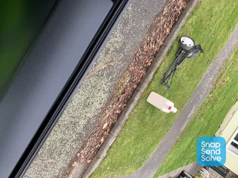
Latest on record
- Rubbish/Recycling at 26 Waipara Street, 30 Jun 2022
Questions, answered briefly
In Hoon Hay, Christchurch, New Zealand.
1 report at 1 address, most often rubbish & dumping (1).
2022, the record covers 1 separate days somebody filed something about it, through 2022.
Everything about Hoon Hay → · Every street the archive knows → · the whole A–Z → · This street as a feed →