Pound Road
6 reports at 4 addresses in McLeans Island, the first in 2018, the latest 2025. 6 separate days somebody filed something about it.
Where it runs
Each report dot is the average of the spots reports were filed from, where reporters stood on Pound Road, not the street’s surveyed line. The strong outline is McLeans Island.
From the air, then
Sourced from Canterbury Maps and partners. LINZ, CC BY 3.0 NZ. Each frame is cut from Environment Canterbury’s historic imagery MapServer for that decade, only where the Footprints layer names a CC BY survey (NZAM-covered spots stay out). RetroLens holds more Crown aerials →
The addresses on it
- 893 Pound Road, 3 reports
- 891 Pound Road, 1 report
- 800 Pound Road, 1 report
- 682 Pound Road, 1 report
What got reported
- Rubbish & dumping, 3 reports
- Roads & footpaths, 3 reports
Year by year
- 2018, 1 report
- 2019, 2 reports
- 2022, 1 report
- 2025, 2 reports
In the written record
Archive documents carrying the street’s name: leads and citations, not verified history. 30 on the shelf; the 12 earliest:
- CHRISTCHURCH. (Star, 11 February 1875)
· Papers Past,
…fined ss robert gimble two horses uigh street fined ss f w delamain eight head of cattle pound road tompleton district fined ss fibb in thr open air james moore for having set fire 13 infummable matt…
- CHRISTCHURCH. (Star, 04 November 1875)
· Papers Past,
…t e borry ono horso east town bolt b bulmer fcwo horsos ferry road b bootfcio fcwo horses pound road jj rosser five horsos no 5 street j h knight fivo horses colombo road a knowles two horses whately…
- Page 2 Advertisements Column 1 (Star, 26 April 1877)
· Papers Past,
…tubdat pbice sixpence teeeh6lp cottage and quarter acre owe seotion from the comer of the pound road on the wilson bridge road fa 8 ofthe ohoicest sites in waltham ith five-roomed hosse in capital rep…
- LOCAL AND GENERAL. (Star, 12 April 1878)
· Papers Past,
…vo long been strangers a 5-inch main has been laid along colombo road south as far as the pound road but not a single lamp-post has as yet been put up this is a matter which concerns the sy denham bor…
- Page 3 Advertisements Column 2 (Star, 20 September 1878)
· Papers Past,
…tho lease and stock-in-trade of mr joseph t barrett at the junctionof colombo street and pound road sydehham the lcaso of i-acre laud with hbuso and shop erected has 17 years to run at a very low gro…
- CHRISTCHURCH. (Star, 07 July 1880)
· Papers Past,
…e bill produced the gooda were pufc oi a dray on juno 22 afc the door of tho storo in the pound road waltham rjho men engaged to work did nofc do anything accused bad not pprmission to dispose of any…
- Page 2 Advertisements Column 5 (Star, 19 July 1880)
· Papers Past,
…dras street south 3100 anted fco sell a fowls house 10 x 20 apply corner of scotfc street pound road sydenham 3098 wanted by a respactable young girl a situation as barmaid or waitress apply a m of��c…
- Page 2 Advertisements Column 6 (Star, 16 May 1881)
· Papers Past,
…d papanui road 8356 wanted a nurse during the day for a sick person apply bromley cottage pound road sydenham 8361 w anted a good general servant refe rences required apply to mra mein hereford streef…
- Page 3 Advertisements Column 1 (Star, 02 August 1882)
· Papers Past,
…e the hon j t peacock a corner shop and dwelling-house at the junc tion of scott read and pound road syden ham also on owner account a fine block of 2a 3r 22p fronting the drain road phillipstown nort…
- Page 2 Advertisements Column 6 (Star, 21 October 1882)
· Papers Past,
…manchester streets fcs73 anted known cure for typhoid fever and rheumatic fever chns cook pound road sydenhain 8575 wanted machinist and assistants to the dressmaking apply miss mehaffy 87 lichfield s…
- CHRISTCHURCH. (West Coast Times, 19 May 1883)
· Papers Past,
…may 18 early this morning three nine-roomed houses belonging to frederick and walter hall pound road sydenham were burned clown the fire was from a cause unknown and began in the kitchen of a house oc…
- Local & General. (Star, 02 January 1884)
· Papers Past,
…who ran away from home no less than five weeks ago was seen and caught by mr rudd in the pound road sydenham yesterday morning he was handed over to the custody of sergeant willis and taken to the po…
The rest are a search away, the whole shelf, for the name →
The crash record on it
NZTA’s record names Pound Road in 20 crashes that hurt somebody since 2006, 8 seriously hurt, nobody killed.
As it was reported



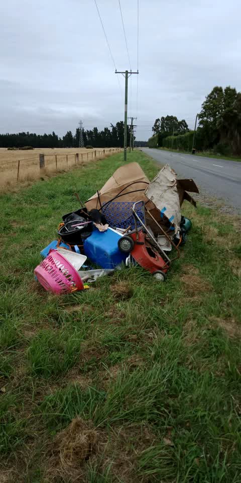

The latest on it
Questions, answered briefly
In McLeans Island, Christchurch, New Zealand.
6 reports at 4 addresses, most often rubbish & dumping (3), roads & footpaths (3).
2018, the record covers 6 separate days somebody filed something about it, through 2025.
Every street the archive knows → · McLeans Island → · This street as a feed →