Glandovey Road
1 council report at 1 address on Glandovey Road, Merivale, on record since December 2025.
Where it runs
Each report dot is the average of the spots reports were filed from, where reporters stood on Glandovey Road, not the street’s surveyed line. The strong outline is Merivale.
From the air, then
Sourced from Canterbury Maps and partners. LINZ, CC BY 3.0 NZ. Each frame is cut from Environment Canterbury’s historic imagery MapServer for that decade, only where the Footprints layer names a CC BY survey (NZAM-covered spots stay out). RetroLens holds more Crown aerials →
The numbered spots
- 128 Glandovey Road, 1 report
What got reported
- Trees & parks, 1 report
Year by year
- 2025, 1 report
Documents that name it
Records on the shelf that name Glandovey Road, 116 in total; the 12 earliest:
- Page 2 Advertisements Column 1 (Star, 12 December 1891) · Papers Past ·
…rches nos 12 13 and 14 1 rood 7 perches eaoh elmwood road section no 42 1 rood 17 perohes glandovey road section no d 9 1 acre 2 perches i have alao let shop victoria etreet house ten rooms cashel str…
- Page 1 Advertisements Column 3 (Star, 20 April 1893) · Papers Past ·
…0 links frontage to glandovey roacl block b2 roods 37 perches having 4 chains frontage to glandovey road and 2 chains to j railway block o2 acres 1 root 30 perches having 5 l chains frontage to glanjv…
- Page 1 Advertisements Column 3 (Star, 22 April 1893) · Papers Past ·
…d road or in sections about quartei l acre block 7 half-acre having 230 links frontage to glandovey road block b2 roods 37 perches having 4 chaina frontage to glandovey road and 2j chains to railway b…
- Page 4 Advertisements Column 4 (Star, 25 April 1893) · Papers Past ·
…ood road or in sections about quarter acre block 7 half-acre having 230 links frontage to glandovey road block b2 roods 37 perches having 4 chains frontage to glandovey road and 2j chains to railway b…
- Page 4 Advertisements Column 3 (Star, 07 March 1895) · Papers Past ·
…et near barbadoes street bridge five rooms plastered and pontry weekly rent 12s fendalton glandovey road four rooms 7s weekly woolston brick shop and dwelling cheap o j hakshall 45 cathedral square sp…
- Page 8 Advertisements Column 2 (Star, 13 February 1897) · Papers Past ·
…l deposit st alb an b madras fctreet section 66ft front age about quartpr-acre 70 btkowan glandovey roadtice high level building site containing holf-ncre 75 st albans barbadoes street quarter-acre an…
- Page 1 Advertisements Column 3 (Star, 10 August 1897) · Papers Past ·
…durham and harpeb streets syden ham about half acre to be sold in one or two ots strowan glandovey road half-acre nice high level building site riccarton cutler eoad corner section containing three-q…
- Page 5 Advertisements Column 4 (Star, 19 March 1898) · Papers Past ·
…ning private papers owner full address within finder rewarded by returning to mrs mdownll glandovey road bryndwr 1329 madame hogan phrenologist palmistry future by cup 81 montreal street third house s…
- Page 8 Advertisements Column 3 (Star, 23 September 1899) · Papers Past ·
…building sites madras barbadoes and fitz gerald streets a few good building sites strowan glandovey road i-acre high level building site 37 10s st albans ranfurly street both sides between chapel stre…
- Page 3 Advertisements Column 5 (Star, 23 August 1901) · Papers Past ·
…rooms bathroom h and c splendid etabling and 1 acre tastefully laid ou 1160 603 fendalton glandovey road house 8 rooms wid verandahs conservatory acre nicely planted northern aspect frontage to wairar…
- Page 3 Advertisements Column 4 (Star, 20 September 1901) · Papers Past ·
…nd 120 621 deans estate west of railway lina charming sitea for residences 501 fenidalton glandovey road half-acres with fronaage to wairarapa stream 85 484 wilson road 1 acre 300 620 sockburn and hor…
- Page 6 Advertisements Column 1 (Star, 28 September 1901) · Papers Past ·
…nd 120 621 deans estate west of railway line charming sites for residences 501 feindalton glandovey road-fialf-acres with frontage to wairarapa stream 85 484 wilson road 1 acre 300 620 sockburn and ho…
The rest are a search away, the whole shelf, for the name →
The named ground
Named water within 150 m of a reported pin, measured to the line or the edge, the open map’s record.
As it was reported
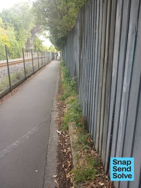
Latest on record
- Overgrown Vegetation at 128 Glandovey Road, 28 Dec 2025
Questions, answered briefly
In Merivale, Christchurch, New Zealand.
1 report at 1 address, most often trees & parks (1).
2025, the record covers 1 separate days somebody filed something about it, through 2025.
Everything about Merivale → · Every street the archive knows → · the whole A–Z → · This street as a feed →