Whitmore Street
1 council report at 1 address on Whitmore Street, Richmond, on record since June 2016.
Where it runs
Each report dot is the average of the spots reports were filed from, where reporters stood on Whitmore Street, not the street’s surveyed line. The strong outline is Richmond.
From the air, then
Sourced from Canterbury Maps and partners. LINZ, CC BY 3.0 NZ. Each frame is cut from Environment Canterbury’s historic imagery MapServer for that decade, only where the Footprints layer names a CC BY survey (NZAM-covered spots stay out). RetroLens holds more Crown aerials →
The numbered spots
- 36 Whitmore Street, 1 report
What got reported
- Graffiti & vandalism, 1 report
Year by year
- 2016, 1 report
Documents that name it
Records on the shelf that name Whitmore Street, 13 in total; the 12 earliest:
- TABLE TALK, (Otago Witness, 27 April 1904) · Papers Past ·
…e cold a jumble sale is being hold by the missions to seamen-in the sailors mission booth whitmore street it is in aid of the winter work and should be a great saooess i miss pearson hes returned from…
- New Zealand Academy of Fine Arts Gallery, Whitmore Street, Wellington · TAPUHI ·
- Page 2 Advertisements Column 4 (Evening Post, 03 October 1922) · Papers Past ·
…one shilling nz academy of fine artj3 annual ixkibition now open daily in the art gallery whitmore street hours 10 am to 530 pm and 730 pm to 930 pm admission is art union tickets is h m gore secretar…
- Page 3 Advertisements Column 7 (Evening Post, 24 November 1923) · Papers Past ·
…the weekday services for the board of missions ailors friend society church and institute whitmore street services at 11 am and 7 pm preacher mr james moore missioner subjects 1 debts we cant pay 2 ou…
- WOMEN IN PRINT. (Evening Post, 21 August 1924) · Papers Past ·
…ost successful function was the wellesloy college dance which was held in the art gallery whitmore street last evening many dancers were present and all tho conditions had been secured that make for s…
- Page 5 Advertisements Column 1 (Evening Post, 22 March 1930) · Papers Past ·
…the as to satisfy the reasonable requirements grand opening season gala to-night to-night whitmore street 7 pm rev m w p lascelles chapel of j etaylor and son ltd 22 down uerk to the saia oocn en nine…
- Page 5 Advertisements Column 2 (Evening Post, 05 November 1932) · Papers Past ·
…ct possessed 530 pmservice in men shelter the sailors friend society church and institute whitmore street sunday-services6th nov 11 ampreacher v mr a macmillan 7 pmpreacher-mr vance soloist mrs ehsell…
- Page 3 Advertisements Column 1 (Evening Post, 04 November 1933) · Papers Past ·
…to-ij ment showroom hope gibbons buildings radio wanted electric 3-4-valve dyna stout and whitmore streets wellington 8 oclock watattat ttwmv a tnt doms abolishedone universal king store truck wheels…
- Page 4 Advertisements Column 2 (Evening Post, 23 March 1935) · Papers Past ·
…ermon 7 pmevensong and sermon priest m charge rev hwhitby james rrhe missions to seamen x whitmore street morning prayer 10 oclock evensong andsermon 7 oclock b j williams miasioner xritish sailors so…
- Page 3 Advertisements Column 5 (Evening Post, 01 June 1935) · Papers Past ·
…j m laird messrs h s hart h n vivianc j mackay and mihier time 745 the missions to seamen whitmore street v morning prayer 10 oclock evensong and sermon 7 oclock b j williams mißsioner dritish sailors…
- Page 5 Advertisements Column 4 (Evening Post, 23 May 1936) · Papers Past ·
…oly communion 7 pmevensong and sermon preacher rev p j davies bsc rjhe missions to seamen whitmore street morning prayer 10 oclock evensong and sermon 7 oclock b j williams missioner trritish sailors…
- TRACE OF MISSING WOMAN (Evening Post, 20 July 1938) · Papers Past ·
…the bicycle and clothing have been identified as belonging to miss eva crowhen aged 22 of whitmore street christchurch she had been missing from her home since monday morning…
The rest are a search away, the whole shelf, for the name →
As it was reported
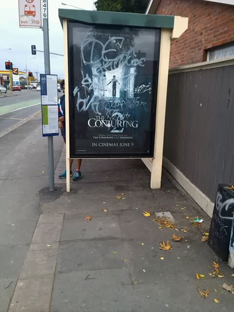
Latest on record
- Graffiti at 36 Whitmore St, 12 Jun 2016
Questions, answered briefly
In Richmond, Christchurch, New Zealand.
1 report at 1 address, most often graffiti & vandalism (1).
2016, the record covers 1 separate days somebody filed something about it, through 2016.
Everything about Richmond → · Every street the archive knows → · the whole A–Z → · This street as a feed →