50 Plynlimon Road, Strowan
12 reports on record since September 2020 · 9 with photographs. The most-reported address on Plynlimon Road. Indicative rating valuation and school zones, hazards, bin day and what stood here before.
What gets reported here
- Park - General Request — 2
- Overgrown Vegetation — 2
- Facility - General Request — 2
- Dumped Rubbish — 2
- Rubbish/Recycling — 1
- Playground Equipment — 1
Photographed here 9 on record


Reported here
 Park - General Request —
 Plants have not been planted properly in the park. Still in small back pots - poor skills
 Fallen Tree —
 Tree uprooted by winds
 Dumped Rubbish —
 Rubbish dumped
 Facility - General Request —
 Damaged rugby post.
 General Request —
 Rugby post down/broken
 Facility - General Request —
 Rugby posts partially down, need putting back up or removed
 Playground Equipment —
 Crossbar on rugby posts at Plynlimon park has become detached from the upright and is currently on the ground. I understand when this came l
 Dumped Rubbish —
 - Overgrown Vegetation —
- Overgrown Vegetation —
- Park - General Request —
Rubbish/Recycling —
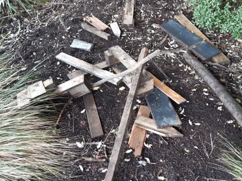
Dumped pile of scrap wood by bin kids playground.
Also reported on Plynlimon Road
- 67 Plynlimon Road — 7 reports
- 46 Plynlimon Road — 5 reports
- 65 Plynlimon Road — 3 reports
- 57 Plynlimon Road — 3 reports
- 48 Plynlimon Road — 3 reports
- 61 Plynlimon Road — 2 reports
- 63 Plynlimon Road — 1 report
- 45 Plynlimon Road — 1 report
The street’s crash record
NZTA’s record names Plynlimon Road in 1 crash that hurt somebody since 2006 — 1 seriously hurt, nobody killed.
The green nearby
- Plynlimon Park — you are in it · Sports ground · 1 ha
- Elmwood Park — 341 m to the edge · Sports ground · 7 ha
Parks within half a kilometre, measured to the boundary — the council’s open data.
On the doorstep
- The Crater Rim — 254 m away · Bottle stores
- Z Espress - Bryndwr — 290 m away · Fast food
- Z — 301 m away · Petrol stations
- RJ Begg & Associates — 310 m away · Dentists
Businesses within four hundred metres, measured at the pin — OpenStreetMap and the council directories.
The bus nearby
The closest Metro stops, within four hundred and fifty metres.
The tracks through here
- Walk and bike track through Strowan — 75 m to the line · walk · bike
- Walk and bike track through Strowan — 162 m to the line · walk · bike
- Walk and bike track through Strowan — 203 m to the line · walk · bike
- Walk and bike track through Strowan — 247 m to the line · walk · bike
- Walk and bike track through Strowan — 316 m to the line · walk · bike
Tracks whose line passes within half a kilometre, measured to the line itself — the council’s open data.
The named ground
Named water within 500 m of this address, measured to the line or the edge; Named places within 1.5 km of this address — the open map’s record.
Renting nearby
new bonds in Strowan ran about $620 a week — $70 above the city median of $550 — the suburb page keeps the rent record →.
The civic layer
This ground votes in Fendalton ward — the Fendalton-Waimairi-Harewood community board. Ward lines don’t always follow suburb lines; this one is measured at the pin, not the suburb’s centre.
What stood on this ground → · On the map → · From the air — the Crown’s aerials back to 1936; search the address on RetroLens →
Questions, answered briefly
12 council reports on record since September 2020 — most often park - general request (2), overgrown vegetation (2), facility - general request (2).
Strowan, Christchurch — on Plynlimon Road.
Nothing on the heritage register at this exact spot — the record around this ground →
Plynlimon Park — the address is inside it, 1 ha.