357 Brougham Street, Sydenham
14 reports on record since September 2022 · 10 with photographs. The street’s heaviest record is 406 Brougham Street — 39 reports on file. Indicative rating valuation and school zones, hazards, bin day and what stood here before.
What gets reported here
Photographed here 10 on record


Reported here
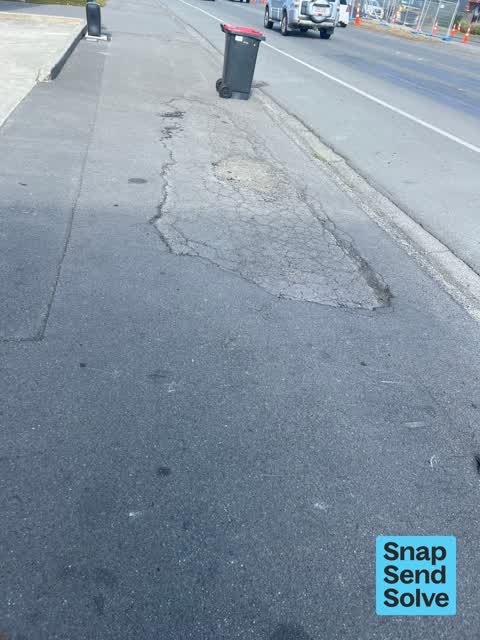
 Pavement - Damaged —
 Footpath all ripped up and dangerous- people tripping
 Graffiti on a fence, building or structure —
 Graffiti on wall. One of many between Wilsons Rd and Gasson St.
 Pavement - Damaged —
 There is a huge hole in the sealed footpath which is very dangerous. My 5 year old daughter fell off her scooter in the loose dirt and rubbl
 Graffiti somewhere else —
  Graffiti somewhere else —
  Graffiti somewhere else —
 Graffiti on this green cabinet
 Pavement - Damaged —
 Large Pothole forming in footpath. Loose debris. Harzardous and unsightly.
 Pavement - Damaged —
 Pothole in path & missing berm to gutter level requires leveling filling & sealing & new berm
 Pavement - Damaged —
 Old driveway entrance berm which is no longer a driveway entrance to be levelled to path height
 Pavement - Damaged —
 Massive pothole in path to level full & seal
- Hazard — vehicle —
- Pavement - Damaged —
- Poles and Signage - General —
- Graffiti —
Also reported on Brougham Street
- 406 Brougham Street — 39 reports
- 240 Brougham Street — 28 reports
- 230 Brougham Street — 15 reports
- 395 Brougham Street — 13 reports
- 297 Brougham Street — 13 reports
- 259 Brougham Street — 10 reports
- 253 Brougham Street — 10 reports
- 240F Brougham Street — 10 reports
The street’s crash record
NZTA’s record names Brougham Street in 50 crashes that hurt somebody since 2006 — 9 seriously hurt, nobody killed.
The green nearby
- Hastings Reserve — 79 m to the edge
- Cameron Reserve — 298 m to the edge
- Tommy Taylor Reserve — 318 m to the edge
- Jacksons Creek — 325 m to the edge
- Cadogan Reserve — 326 m to the edge
Parks within half a kilometre, measured to the boundary — the council’s open data.
On the doorstep
- X-Ten Collective — 136 m away · Cafés
- Prima Roastery — 139 m away · Coffee roasters
- The Science Shop — 158 m away · Toy shops
- FAB Lab CHCH — 167 m away · Makerspaces
Businesses within four hundred metres, measured at the pin — OpenStreetMap and the council directories.
The bus nearby
- Brougham St near Brisbane St — 77 m away · route 8
- Brougham St near Brisbane St — 92 m away · route 8
The closest Metro stops, within four hundred and fifty metres.
The tracks through here
- Walk and bike track through Sydenham — 86 m to the line · walk · bike
- Walk and bike track through Sydenham — 292 m to the line · walk · bike
- Walk and bike track through Sydenham — 298 m to the line · walk · bike
- Walk and bike track through Sydenham — 490 m to the line · walk · bike
Tracks whose line passes within half a kilometre, measured to the line itself — the council’s open data.
The named ground
Named water within 500 m of this address, measured to the line or the edge — the open map’s record.
Renting nearby
new bonds in Sydenham ran about $518 a week — $32 below the city median of $550 — the suburb page keeps the rent record →.
The civic layer
This ground votes in Heathcote ward — the Spreydon-Cashmere-Heathcote community board. Ward lines don’t always follow suburb lines; this one is measured at the pin, not the suburb’s centre.
What stood on this ground → · On the map → · From the air — the Crown’s aerials back to 1936; search the address on RetroLens →
Questions, answered briefly
14 council reports on record since September 2022 — most often pavement - damaged (7), graffiti somewhere else (3), poles and signage - general (1).
Sydenham, Christchurch — on Brougham Street.
Nothing on the heritage register at this exact spot — the record around this ground →
Hastings Reserve — 79 m to its edge.