455 Colombo Street, Sydenham
27 reports on record since July 2018 · 22 with photographs. The street’s heaviest record is 468 Colombo Street — 71 reports on file. Indicative rating valuation and school zones, hazards, bin day and what stood here before.
What gets reported here
Photographed here 22 on record




Reported here
 Graffiti on a fence, building or structure —
 graffiti on light lamp post pole
 Graffiti on a road, footpath or bridge —
 multiple graffiti on green rails of bridge
 Graffiti on a road, footpath or bridge —
 multiple graffiti on bollards under bridge
 Graffiti on a fence, building or structure —
 graffiti on light lamp post pole nearby
 Graffiti on a traffic light pole or cabinet, or wa —
 graffiti on traffic control cabinet
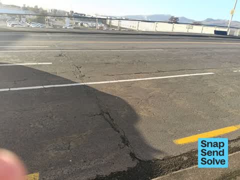
 Damaged Road —
 VERY DAMAGED ROAD NEEDS RESEALING EFFECTIVE AS OF IMMEDIATELY IT'S WORSE THAN EVER PLEASE DO YOUR JOB PROPERLY LOOK AFTER OUR ROADS
 Graffiti on a fence, building or structure —
 graffiti on wall roof height
 Graffiti on a fence, building or structure —
 Graffiti, on side of the old Dalgety building, Colombo Street corner Moorhouse Avenue, Sydenham.Thanks Please notify me when this SSS is sol
 Litter —
 Rubbish every where thought it was kiwi rail problem
 Graffiti on a fence, building or structure —
 Graffiti on side of Laser Strike? building corner Colombo Street/ Moorhouse Avenue CBD Christchurch. ( Previous graffiti only removed this w
 Graffiti on a fence, building or structure —
 Graffiti on side of " Laser Strike " ? building, corner Colombo Street/Moorhouse Ave CBD ChCh. Thanks. Please notify me when this SSS is s
 Graffiti on a fence, building or structure —
 graffiti on wall
 Water Leak —
  Dumped Rubbish —
 There are fibre cement boards on the side of the road that might contain asbestos.
 Graffiti on a road, footpath or bridge —
  Roads - General —
 Metal railings missing on Colombo Street road bridge, above railway line, near Moorhouse Avenue CBD ChCh.Thanks. Please notify
 Graffiti on a traffic light pole or cabinet, or wa —
 graffiti on traffic lights near over bridge colombo st
 Graffiti on a fence, building or structure —
 graffiti on whole Eastside facing of Harvey Norman building
 Graffiti on a fence, building or structure —
 Graffiti on side wall
 Graffiti on a fence, building or structure —
 Tags (plus sticky tags galore) on 2 Rockgas assets at 455 Colombo Street.
- Graffiti —
- Poles and Signage - General —
- Graffiti —
- Road Signage —
- Graffiti —
 Vandalism - General —
 More graffiti on a brand new untenanted building
Graffiti —
Lamp post
Also reported on Colombo Street
- 468 Colombo Street — 71 reports
- 300 Colombo Street — 66 reports
- 303 Colombo Street — 64 reports
- 504 Colombo Street — 56 reports
- 340 Colombo Street — 52 reports
- 406 Colombo Street — 37 reports
- 500 Colombo Street — 36 reports
- 420 Colombo Street — 36 reports
The street’s crash record
NZTA’s record names Colombo Street in 200 crashes that hurt somebody since 2006 — 2 people killed, 35 seriously hurt.
The green nearby
- Carlyle Reserve — 23 m to the edge
- Buchan Playground — 387 m to the edge
- Science Alive Reserve — 421 m to the edge
- Gasson Reserve — 481 m to the edge
Parks within half a kilometre, measured to the boundary — the council’s open data.
On the doorstep
- The Drawing Room — 37 m away · Craft
- Extrastaff — 42 m away · Recruitment
- Crate Escape - Sydenham — 65 m away · Attractions
- Christchurch Premium Cars — 88 m away · Car dealers
Businesses within four hundred metres, measured at the pin — OpenStreetMap and the council directories.
The bus nearby
- Colombo St near Cass St — 82 m away · route 1, route 8, route 44
- Moorhouse Ave near Moorhouse Ave Slip S — 157 m away · route 140
The closest Metro stops, within four hundred and fifty metres.
The tracks through here
- Walk and bike track through Sydenham — 11 m to the line · walk · bike
- Walk and bike track through Sydenham — 165 m to the line · walk · bike
- Walk and bike track through Sydenham — 165 m to the line · walk · bike
- Walk and bike track through Sydenham — 165 m to the line · walk · bike
- Walk and bike track through Sydenham — 304 m to the line · walk · bike
Tracks whose line passes within half a kilometre, measured to the line itself — the council’s open data.
The named ground
Named places within 1.5 km of this address — the open map’s record.
Renting nearby
new bonds in Sydenham ran about $518 a week — $32 below the city median of $550 — the suburb page keeps the rent record →.
What was here — New City Hotel and Setting
250 m away · located to ±20 m · the place’s own record →
On the register. Nothing researched here yet.
The civic layer
This ground votes in Heathcote ward — the Spreydon-Cashmere-Heathcote community board. Ward lines don’t always follow suburb lines; this one is measured at the pin, not the suburb’s centre.
What stood on this ground → · On the map → · From the air — the Crown’s aerials back to 1936; search the address on RetroLens →
Questions, answered briefly
27 council reports on record since July 2018 — most often graffiti on a fence, building or structure (10), graffiti (4), graffiti on a road, footpath or bridge (3).
Sydenham, Christchurch — on Colombo Street.
The heritage register names a place at or beside it — New City Hotel and Setting.
Carlyle Reserve — 23 m to its edge.