151A Taylors Mistake Road
2 council reports since June 2022, 2 carrying a photograph. The street’s heaviest record is 225 Taylors Mistake Road, 24 reports on file.
On the register here
- Taylors Mistake Bach 1, 68 Taylors Mistake Bay (119m)
- 69 Taylors Mistake Bay, 69 Taylors Mistake Bay (129m)
- 70 Taylors Mistake Bay, 70 Taylors Mistake Bay (207m)
- 60 Taylors Mistake Bay, 60 Taylors Mistake Bay (221m)
- Taylors Mistake Bach 2, 59 Taylors Mistake Bay (242m)
From the air, then
Sourced from Canterbury Maps and partners. RNZAF, CC BY 3.0 NZ. Each frame is cut from Environment Canterbury’s historic imagery MapServer for that decade, only where the Footprints layer names a CC BY survey (NZAM-covered spots stay out). RetroLens holds more Crown aerials →
The green nearby
- Giants Nose, 82 m to the edge · Regional · 2 ha
- Taylors Mistake Beach, 96 m to the edge · Regional · 9 ha · playground, 7 pieces
- Whitewash Reserve, 134 m to the edge · Regional · 9 ha
Parks within half a kilometre, measured to the boundary, the council’s open data. The whole roll is at /parks.
The named ground
Named places within 1.5 km of this address; the council’s own structure register, bridges, boardwalks and steps standing nearby, the open map’s record.
The remembered names nearby
- Trish & Rick'S / Seat, 200 m away ·
TRISH & RICK'S / SEAT / (Sit, relax and enjoy the view – lower line partly illegible)
· 2009
Inscribed plaques within two hundred and fifty metres, the register’s pins, not surveyed spots. The whole roll is at /plaques.
What gets reported here
- Roading/Streets, 1
- General Request, 1
Photographed here 2 on record

What’s on record
 General Request, 18 Mar 2025
There seems to have been Solar Panels installed in the area circled in red. Many mature trees have been felled. Along with the solar panels
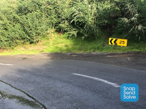
 Roading/Streets, 3 Jun 2022
New road signs showing 40 are in place and this one is in the wrong place. As you drive down the sign shows 25 which is correct. Then the n
Elsewhere on Taylors Mistake Road
- 225 Taylors Mistake Road, 24 reports
- 224 Taylors Mistake Road, 19 reports
- 229 Taylors Mistake Road, 11 reports
- 223 Taylors Mistake Road, 6 reports
- 226 Taylors Mistake Road, 5 reports
- 175 Taylors Mistake Road, 4 reports
- 163B Taylors Mistake Road, 4 reports
- 163A Taylors Mistake Road, 4 reports
The street’s crash record
NZTA’s record names Taylors Mistake Road in 2 crashes that hurt somebody since 2006, 1 seriously hurt, nobody killed.
The civic layer
This ground votes in Heathcote ward, the Spreydon-Cashmere-Heathcote community board is its local layer. Ward lines don’t always follow suburb lines; this one is measured at the pin, not the suburb’s centre. The whole roll is at /wards.
Taylors Mistake Road, the whole record → · Everything about te-onepoto-taylors-mistake → · What stood on this ground → · On the map → · From the air, RetroLens holds the Crown’s aerials back to 1936; search the address there →
Questions, answered briefly
2 council reports on record since June 2022, most often roading/streets (1), general request (1).
te-onepoto-taylors-mistake, Christchurch, on Taylors Mistake Road.
The heritage register names 5 places at or beside it, Taylors Mistake Bach 1, 69 Taylors Mistake Bay.
Giants Nose, 82 m to its edge, 2 ha.