76 Kirk Road, Templeton
17 reports on record since October 2020 · 14 with photographs. The street’s heaviest record is 39 Kirk Road — 61 reports on file. Indicative rating valuation and school zones, hazards, bin day and what stood here before.
What gets reported here
Photographed here 14 on record


Reported here
 Damaged Road —
 Pot hole in road.
 Overgrown Vegetation —
 Overgrown vegetation is blocking line of sight from the intersection of Maddisons Road and Kirk road making it hard to see and it’s unsafe c
 Street Gutters / Storm Water —
 blocked culvert. there is water flow through and Ive fished out what I can reach but there's quite a lot stuck so the water is backing up a
 Damaged Street Sign —
 Templeton 50 sign is laying in the garden
 Damaged Street Sign —
 50km road sign down again. lasted about two weeks up this time
 Road Signage —
 Reduce speed sign has been knocked or fallen over can this please be placed back in the ground
 Road Signage —
 50km sign down again
 Road Signage —
 50km sign knocked down again
 Damaged Street Sign —
  Vandalism - General —
 50km sign west of Templeton, on zkirk Rd is down again!!! About 4th time in as many months. Repair needs to be better & less able to be pu
 Damaged Street Sign —
 This sign was put back in ground recently after lying down for months. It does not appear to have been done to any standard of repair that a
 Damaged Street Sign —
 This sign is on the ground again. Please repair
- Damaged Street Sign —
- Road Signage —
- Damaged Street Sign —
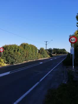 Parks —
 Coming into Templeton the Red Roybn shrubs have grown to a height we're the 50km reduce speed signs can't be seen, the signs either need to
Vandalism - General —
One leg smashed and sign turned around.
Also reported on Kirk Road
- 39 Kirk Road — 61 reports
- 62 Kirk Road — 20 reports
- 64 Kirk Road — 13 reports
- 31 Kirk Road — 13 reports
- 71 Kirk Road — 11 reports
- 57 Kirk Road — 10 reports
- 91 Kirk Road — 6 reports
- 40 Kirk Road — 6 reports
The street’s crash record
NZTA’s record names Kirk Road in 45 crashes that hurt somebody since 2006 — 1 person killed, 9 seriously hurt.
The green nearby
- Kirk Reserve — 245 m to the edge · 2 ha
- Azalea Reserve — 254 m to the edge
- Templeton Domain — 338 m to the edge · Sports ground · 3 ha
- Colchester Reserve — 476 m to the edge
Parks within half a kilometre, measured to the boundary — the council’s open data.
The civic shelf nearby
- Templeton — 396 m away · Recreation centre · 62 Kirk Road
Libraries, halls and the rest within half a kilometre — the council’s open data.
On the doorstep
- Templeton Community Centre — 347 m away · Venues & events
Businesses within four hundred metres, measured at the pin — OpenStreetMap and the council directories.
Renting nearby
new bonds in Templeton ran about $620 a week — $70 above the city median of $550 — the suburb page keeps the rent record →.
The civic layer
This ground votes in Hornby ward — the Halswell-Hornby-Riccarton community board. Ward lines don’t always follow suburb lines; this one is measured at the pin, not the suburb’s centre.
What stood on this ground → · On the map → · From the air — the Crown’s aerials back to 1936; search the address on RetroLens →
Questions, answered briefly
17 council reports on record since October 2020 — most often damaged street sign (7), road signage (4), vandalism - general (2).
Templeton, Christchurch — on Kirk Road.
Nothing on the heritage register at this exact spot — the record around this ground →
Kirk Reserve — 245 m to its edge, 2 ha.