57 Acacia Ave Christchurch 8041 Canterbury Region New Zealand
1 council report since February 2026, 1 carrying a photograph.
On the register here
The green nearby
- Middleton Park, 138 m to the edge · Sports ground · 5 ha · playground, 5 pieces
- Auburn Reserve, 378 m to the edge · 1 ha · playground, 23 pieces
- Hansons Reserve, 477 m to the edge · playground, 42 pieces
Parks within half a kilometre, measured to the boundary, the council’s open data. The whole roll is at /parks.
On the doorstep
- S4spice, 108 m away · Grocery
- Alumni House, 180 m away · B&Bs
- 101 Stars Motel, 317 m away · Hotels
- Alpha Motel Luxury Accommodation, 320 m away · Motels
Businesses within four hundred metres, measured at the pin, OpenStreetMap and the council directories.
The bus nearby
- Blenheim Rd near Penn Pl, 318 m away · route 80
- Blenheim Rd near Penn Pl, 331 m away · route 80
The closest Metro stops, within four hundred and fifty metres.
The tracks through here
- Walk and bike track through Upper Riccarton, 186 m to the line · walk · bike
- Walk and bike track through Upper Riccarton, 240 m to the line · walk · bike
- Walk and bike track through Upper Riccarton, 319 m to the line · walk · bike
- Walk and bike track through Upper Riccarton, 414 m to the line · walk · bike
- Walk and bike track through Upper Riccarton, 447 m to the line · walk · bike
Tracks whose line passes within half a kilometre, the council’s open data.
What gets reported here
Photographed here 1 on record

What’s on record
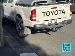 Hazard, vehicle, 24 Feb 2026
Vehicle parked within 1 m of my driveway and making it difficult to enter and exit, with the street parked out on both side sides.
The civic layer
This ground votes in Riccarton ward, the Halswell-Hornby-Riccarton community board is its local layer. Ward lines don’t always follow suburb lines; this one is measured at the pin, not the suburb’s centre. The whole roll is at /wards.
Acacia Ave Christchurch 8041 Canterbury Region New Zealand, the whole record → · Everything about Upper Riccarton → · What stood on this ground → · On the map → · Street View → · From the air, RetroLens holds the Crown’s aerials back to 1936; search the address there →
Questions, answered briefly
1 council report on record since February 2026, most often hazard, vehicle (1).
Upper Riccarton, Christchurch, on Acacia Ave Christchurch 8041 Canterbury Region New Zealand.
The heritage register names a place at or beside it, Former Dwelling and Setting, Middleton.
Middleton Park, 138 m to its edge, 5 ha.