52 Mowbray Street, Waltham
16 reports on record since February 2018 · 10 with photographs. The street’s heaviest record is 54 Mowbray Street — 34 reports on file. Indicative rating valuation and school zones, hazards, bin day and what stood here before.
What gets reported here
Photographed here 10 on record


Reported here
 Graffiti on a fence, building or structure —
 Graffiti on wall and unknown cabinet.
 Graffiti on a fence, building or structure —
 graffiti on fence
 Graffiti on a fence, building or structure —
 Graffiti on concrete wall opposite 52
 Graffiti on a fence, building or structure —
 Graffiti on concrete fence
 Graffiti on a fence, building or structure —
 Graffiti on concrete fence
 Graffiti on a traffic light pole or cabinet, or wa —
 Graffiti on backflow system
 Graffiti somewhere else —
  Water Leak —
 This is flooded please fix this. Not good enough. Wouldn’t leave a closed road like this. Also needs cones blocking entrance as you bike bik
- Flooding —
- Flooding —
- Road Blockage —
- Flooding —
- Flooding —
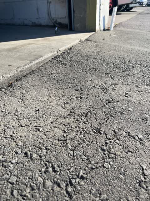
- Pavement - General —
 Roading/Streets —
 The footpath outside our commercial property is dropping. This presents a hazard to pedestrians.
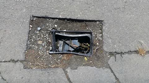
Water Supply —
Broken cover
Also reported on Mowbray Street
- 54 Mowbray Street — 34 reports
- 69 Mowbray Street — 10 reports
- 29 Mowbray Street — 10 reports
- 112 Mowbray Street — 10 reports
- 103 Mowbray Street — 10 reports
- 110 Mowbray Street — 8 reports
- 89 Mowbray Street — 7 reports
- 111 Mowbray Street — 7 reports
The street’s crash record
NZTA’s record names Mowbray Street in 5 crashes that hurt somebody since 2006 — 1 seriously hurt, nobody killed.
The green nearby
- Thackeray Reserve — 296 m to the edge
- Tommy Taylor Reserve — 457 m to the edge
Parks within half a kilometre, measured to the boundary — the council’s open data.
On the doorstep
- Hang Up Entertainment — 91 m away · Rental
- The Crafted Coffee Company - Shakespeare Road — 110 m away · Cafés
- Spectrum Lighting & Sound — 127 m away · Rental
- Hyde Park Hire — 137 m away · Rental
Businesses within four hundred metres, measured at the pin — OpenStreetMap and the council directories.
The bus nearby
- Waltham Rd near Coleridge St — 286 m away · route 8, route 27
- Waltham Rd near Mowbray St — 293 m away · route 8, route 27
The closest Metro stops, within four hundred and fifty metres.
The tracks through here
- Walk and bike track through Waltham — 16 m to the line · walk · bike
- Walk and bike track through Waltham — 27 m to the line · walk · bike
- Walk and bike track through Waltham — 187 m to the line · walk · bike
- Walk and bike track through Waltham — 198 m to the line · walk · bike
- Walk and bike track through Waltham — 269 m to the line · walk · bike
Tracks whose line passes within half a kilometre, measured to the line itself — the council’s open data.
Renting nearby
new bonds in Waltham ran about $463 a week — $87 below the city median of $550 — the suburb page keeps the rent record →.
The civic layer
This ground votes in Heathcote ward — the Spreydon-Cashmere-Heathcote community board. Ward lines don’t always follow suburb lines; this one is measured at the pin, not the suburb’s centre.
What stood on this ground → · On the map → · From the air — the Crown’s aerials back to 1936; search the address on RetroLens →
Questions, answered briefly
16 council reports on record since February 2018 — most often graffiti on a fence, building or structure (5), flooding (4), water supply (1).
Waltham, Christchurch — on Mowbray Street.
Nothing on the heritage register at this exact spot — the record around this ground →
Thackeray Reserve — 296 m to its edge.