36 Taramea Place, Addington
36 reports on record since January 2020 · 24 with photographs. The most-reported address on Taramea Place. Indicative rating valuation and school zones, hazards, bin day and what stood here before.
What gets reported here
Photographed here 24 on record




Reported here
 Dumped Rubbish —
 1 x mattress
 Dumped Rubbish —
  Graffiti on a traffic light pole or cabinet, or wa —
 graffiti on traffic control cabinet nearby
 Road Signage —
 Plz could you replace this Barrington St sign - faded and illegible now ???? Nearby Neville St new sign is great! Thanku.
 Graffiti on a traffic light pole or cabinet, or wa —
 Tagging on traffic signal box
 Roads - General —
 Cars are using the left side right turning lane to go straight. This makes sense as there is a lane opposite that they can go into. The stra
 Traffic Signals —
 Since some traffic lights were replaced on this intersection. these set of lights turn green arrows for turning left and right first for age
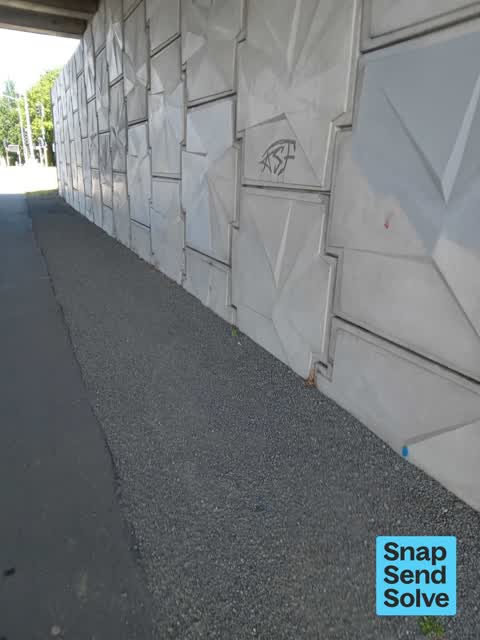
 Graffiti on a road, footpath or bridge —
 Graffiti under the overpass between Jerrold Street South and Jerrold Street North.
 Dumped Rubbish —
 - Roads - General —
Coming off the motorway, heading towards town, there is one straight through lane at this intersection that heads back towards Brougham Stre
 Graffiti on a cabinet, pole or railway asset —
 Cabinet tagging by the Barrington Street under pass.
 Graffiti on a cabinet, pole or railway asset —
 On traffic lights cabinet
 Graffiti somewhere else —
  Graffiti on a cabinet, pole or railway asset —
 Graffiti on teal electrical box at the intersection between state highway 76 and Barrington Street
 Graffiti on a bus stop or public toilet —
 Tagging
 General Request —
 Unknown resident complaining this non ccc bin has been here for 12 months.
 Graffiti —
  Graffiti —
 This tag has been reported several times. It has been here for over s month.
- Dumped Rubbish —
- Graffiti —
- Graffiti —
- Roads - General —
- Graffiti —
- Rubbish and Bins - General —
- Poles and Signage - General —
- Roads - General —
- Dumped Rubbish —
- Dumped Rubbish —
- Roads - General —
 Road Signage —
 Yellow light unhinged
 Graffiti —
 Southern motorway overpass
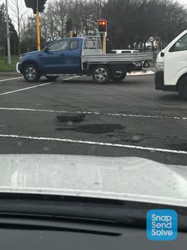
 Pothole —
 Massive pot hole at bottom of motorway where it exits to Barrington street. Been there for a week. Popped my tyre. Thanks
 Damaged Road —
 Half metre wide pothole in ground. Huge pice of tarseal blocking road
 Pothole —
 Had guy on bike complaine to me about it
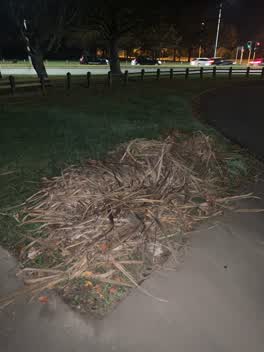 Rubbish/Recycling —
 Rubbiish on grass verge
Roading/Streets —
Advertisement Trailer parked on road reserve.
Also reported on Taramea Place
- 51 Taramea Place — 16 reports
- 1 Taramea Place — 9 reports
- 30 Taramea Place — 4 reports
- 38 Taramea Place — 3 reports
- 2 Taramea Place — 3 reports
- 32 Taramea Place — 2 reports
- 3 Taramea Place — 2 reports
- 18 Taramea Place — 2 reports
The street’s crash record
NZTA’s record names Taramea Place in 3 crashes that hurt somebody since 2006 — 2 seriously hurt, nobody killed.
The green nearby
- Addington Park — 34 m to the edge · Sports ground · 3 ha
- Parade Court Reserve — 261 m to the edge
- Leith Reserve — 310 m to the edge
- Jerrold Reserve — 435 m to the edge
- Walsall Reserve — 459 m to the edge
Parks within half a kilometre, measured to the boundary — the council’s open data.
On the doorstep
- Addington Motel Raceway — 189 m away · Motels
- Raceway Motel — 198 m away · Motels
- Z — 222 m away · Petrol stations
- Z2O — 222 m away · Car washes
Businesses within four hundred metres, measured at the pin — OpenStreetMap and the council directories.
The bus nearby
The closest Metro stops, within four hundred and fifty metres.
The tracks through here
- Walk and bike track through Addington — 20 m to the line · walk · bike
- Walk and bike track through Addington — 121 m to the line · walk · bike
- Walk and bike track through Addington — 248 m to the line · walk · bike
- Walk and bike track through Addington — 265 m to the line · walk · bike
Tracks whose line passes within half a kilometre, measured to the line itself — the council’s open data.
The named ground
Named water within 500 m of this address, measured to the line or the edge; Named places within 1.5 km of this address; the council’s own structure register — bridges, boardwalks and steps standing nearby — the open map’s record.
Renting nearby
new bonds in Addington ran about $502 a week — $48 below the city median of $550 — the suburb page keeps the rent record →.
The civic layer
This ground votes in Spreydon ward — the Spreydon-Cashmere-Heathcote community board. Ward lines don’t always follow suburb lines; this one is measured at the pin, not the suburb’s centre.
What stood on this ground → · On the map → · From the air — the Crown’s aerials back to 1936; search the address on RetroLens →
Questions, answered briefly
36 council reports on record since January 2020 — most often graffiti (6), dumped rubbish (6), roads - general (5).
Addington, Christchurch — on Taramea Place.
Nothing on the heritage register at this exact spot — the record around this ground →
Addington Park — 34 m to its edge, 3 ha.