43 Parlane Street, Addington
29 reports on record since December 2019 · 22 with photographs. The most-reported address on Parlane Street. Indicative rating valuation and school zones, hazards, bin day and what stood here before.
What gets reported here
Photographed here 22 on record




Reported here
 Overgrown Vegetation —
 Flax plants restricting visibility at the intersection. These flax bushes need to be removed and replaced by some low growing plants. The s
 Dumped Rubbish —
  Graffiti on a traffic light pole or cabinet, or wa —
 Graffiti
 Overgrown Vegetation —
 this flax is over grown and is a sight line issue. it's dangerous and you can't see properly when turning in or out of the st it would be be
 Graffiti on a fence, building or structure —
 graffiti on wooden fence poulson st side
 Graffiti on a fence, building or structure —
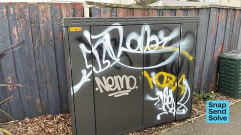
 Small cabinet next to enable box
 Graffiti on a fence, building or structure —
 graffiti on both sides of corner
 Dumped Rubbish —
 Rubbish been left - been here since last week
 Dumped Rubbish —
  Dumped Rubbish —
 3 old tyre rims dumped on the verge outside 43 Parlane Street need removal.
 Graffiti on a cabinet, pole or railway asset —
 On a green cabinet corner of Parlane and Poulson St. On number 43 Parlane St fence line.
 Graffiti on a cabinet, pole or railway asset —
 On a power pole at the intersection of Parlane street and Poulson street.
 Graffiti on a fence, building or structure —
  Graffiti on a cabinet, pole or railway asset —
  Graffiti —
 Red, black and silver paint tags on your asset at the corner of Poulson and Parlane Streets. Needs a new ID also. Suggestion: consider using
- Dumped Rubbish —
- Dumped Rubbish —
- Dumped Rubbish —
- Graffiti —
- Water Leak —
- Graffiti —
- Graffiti —
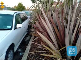 Roading/Streets —
 Unable to see oncoming traffic down street when exiting driveway
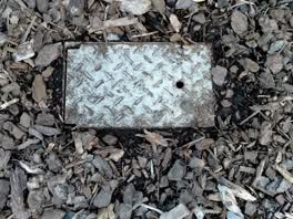 Water Leak —
 This toby is full of leaking water. This was reported about 12 months ago and I had assumed was fixed...but maybe not
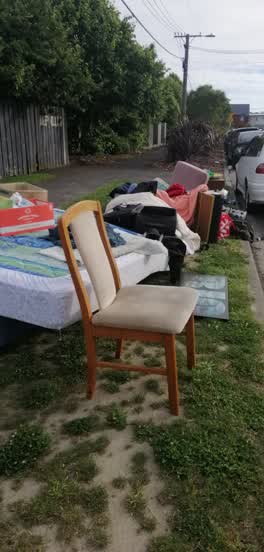 Rubbish/Recycling —
 All this was dumped outside our property last night and there is some across the road. This is round the corner on poulson St
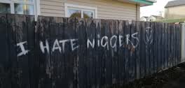 Graffiti —
 We have painted over it but are worried about the content of it and should anyone else be notified.
Rubbish/Recycling —
43 parlance
Rubbish/Recycling —
electronic rubbish in a black plastic bag
Graffiti —
chorus box
Also reported on Parlane Street
- 2 Parlane Street — 13 reports
- 44 Parlane Street — 12 reports
- 22 Parlane Street — 12 reports
- 36 Parlane Street — 11 reports
- 4 Parlane Street — 9 reports
- 31 Parlane Street — 8 reports
- 19 Parlane Street — 8 reports
- 26 Parlane Street — 7 reports
The street’s crash record
NZTA’s record names Parlane Street in 10 crashes that hurt somebody since 2006 — 2 seriously hurt, nobody killed.
The green nearby
- Mountfort Park — 129 m to the edge · Botanic
- Addington Park — 249 m to the edge · Sports ground · 3 ha
- Jerrold Reserve — 326 m to the edge
- Cornelius O'connor Reserve — 413 m to the edge
- Walsall Reserve — 419 m to the edge
Parks within half a kilometre, measured to the boundary — the council’s open data.
On the doorstep
- Jailhouse Accommodation — 159 m away · Hostels
- Card Merchant — 205 m away · Games
- Augustine Outlet — 213 m away · Clothing
- Mini Moocher — 213 m away · Clothing
Businesses within four hundred metres, measured at the pin — OpenStreetMap and the council directories.
The bus nearby
- Addington Village — 265 m away · route 120, route 7
- Addington Village — 284 m away · route 7, route 120
The closest Metro stops, within four hundred and fifty metres.
The tracks through here
- Walk and bike track through Addington — 209 m to the line · walk · bike
- Walk and bike track through Addington — 251 m to the line · walk · bike
- Walk and bike track through Addington — 253 m to the line · walk · bike
- Walk and bike track through Addington — 312 m to the line · walk · bike
- Walk and bike track through Addington — 366 m to the line · walk · bike
Tracks whose line passes within half a kilometre, measured to the line itself — the council’s open data.
The named ground
Named water within 500 m of this address, measured to the line or the edge; Named places within 1.5 km of this address; the council’s own structure register — bridges, boardwalks and steps standing nearby — the open map’s record.
The remembered names nearby
- Charles Dickens (1812 - 1870) Was One of the Most Popular — 210 m away ·
Charles Dickens (1812 - 1870) was one of the most popular English novelists of the Victori
· 2013
Inscribed plaques within two hundred and fifty metres — the register’s pins, not surveyed spots. The whole roll is at /plaques.
Renting nearby
new bonds in Addington ran about $502 a week — $48 below the city median of $550 — the suburb page keeps the rent record →.
What was here — Former Addington Gaol, Wall and Setting
182 m away · 15/336 Lincoln Road · located to ±69 m · the place’s own record →
On the register. Nothing researched here yet.
The civic layer
This ground votes in Spreydon ward — the Spreydon-Cashmere-Heathcote community board. Ward lines don’t always follow suburb lines; this one is measured at the pin, not the suburb’s centre.
What stood on this ground → · On the map → · From the air — the Crown’s aerials back to 1936; search the address on RetroLens →
Questions, answered briefly
29 council reports on record since December 2019 — most often dumped rubbish (7), graffiti (6), graffiti on a fence, building or structure (4).
Addington, Christchurch — on Parlane Street.
The heritage register names a place at or beside it — Former Addington Gaol, Wall and Setting.
Mountfort Park — 129 m to its edge.