47 Fairfield Avenue, Addington
40 reports on record since October 2015 · 32 with photographs. The street’s heaviest record is 72 Fairfield Avenue — 47 reports on file. Indicative rating valuation and school zones, hazards, bin day and what stood here before.
What gets reported here
- Fallen Tree — 9
- Dumped Rubbish — 9
- Parks — 4
- Overgrown Vegetation — 3
- Graffiti — 2
- Water Leak — 1
Photographed here 32 on record


Reported here
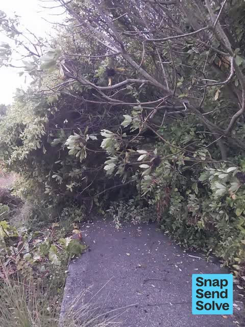
 Fallen Tree —
 tree has fallen across the path. very difficult to navigate around.
 Dumped Rubbish —
 Dumped washing machine
 Dumped Rubbish —
 Outside 51
 Graffiti on a sign, mural or public art —
 graffiti on cemetery sign
 Dumped Rubbish —
 Been here for months.
 Overgrown Vegetation —
 A tree was cut down and it’s still very messy in that space, the logs haven’t been collected and people are adding rubbish to the heap!
 Fallen Tree —
 Fallen tree blocking path into addington cemetery
 Fallen Tree —
 Blocking path
 Fallen Tree —
 Pathway blocked by fallen tree/ large bush.
 Overgrown Vegetation —
 Tree fallen over path blocking path and needs clearing
 Fallen Tree —
 Fallen tree blocking path from Fairfield ave into Addington cemetery
 Fallen Tree —
 Fallen tree branch covering footpath access into Addington cemetery Fairfield st
 Fallen Tree —
 Fallen tree at entry to Addington Cemetery entrance on Fairfield Ave. it blocks walking path completely.
 Overgrown Vegetation —
 Tree has fallen completely blocking footpath
 Fallen Tree —
 Tree across path in to Addington Cemetery
 Fallen Tree —
  Park - General Request —
 Location: Baxters creek Unknown owner of shopping trolley
 Dumped Rubbish —
  Dumped Rubbish —
 Unmarked trolley and assorted rubbish at southern entrance to Addington cemetery
 Dumped Rubbish —
 Fairfield st entrance to addington cemetery has dumped rubbish
 Dumped Rubbish —
  Vandalism - General —
 Plaque has been stolen on Fairfield Ave
- Litter —
- Facility - General Request —
- General Request —
- Dumped Rubbish —
- Dumped Rubbish —
- Damaged Street Sign —
- Street Gutters / Storm Water —
- Flooding —
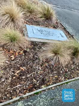 Graffiti —
 Graffiti on drain cover and on sign into Addington cemetery
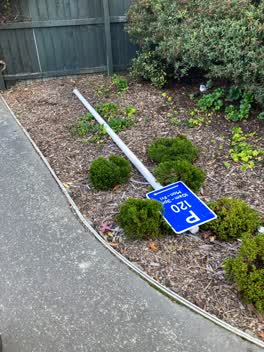 Parks —
 Someone has ripped up a parking sign and thrown it in the bushes.
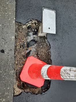 Water Leak —
  Rubbish/Recycling —
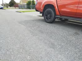
 The tenants at 41 Fairfield Avenue have had a party and left bottles and cans on the street. They've also smashed a car window and there is
Sewer - General —
Overgrown and dirty drain
Animal - Deceased —
Ginger cat in drainpipe, about half a meter in
 Parks —
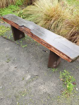
 Baxter's drain seat damaged, next to Addington Cemetery
Parks —
tires dumped
Graffiti —
Graffiti on seats in Baxters Drain Reserve
Parks —
The lever from the working the drain is missing and needs replacing. The bolts holding the plaque in place has one missing making it more vu
Also reported on Fairfield Avenue
- 72 Fairfield Avenue — 47 reports
- 33 Fairfield Avenue — 19 reports
- 68B Fairfield Avenue — 14 reports
- 80 Fairfield Avenue — 11 reports
- 64 Fairfield Avenue — 11 reports
- 48 Fairfield Avenue — 11 reports
- 39 Fairfield Avenue — 11 reports
- 68A Fairfield Avenue — 10 reports
The street’s crash record
NZTA’s record names Fairfield Avenue in 7 crashes that hurt somebody since 2006 — 0 seriously hurt, nobody killed.
The green nearby
- Baxters Drain — 23 m to the edge
- Addington Cemetery — 33 m to the edge · Botanic · 2 ha
- Ruskin Reserve — 123 m to the edge
- Braddon Reserve — 201 m to the edge
- Disraeli Reserve — 221 m to the edge
Parks within half a kilometre, measured to the boundary — the council’s open data.
On the doorstep
- Richfields — 240 m away · Delis
- Creative Junk — 264 m away · Variety Store
- Atlas Gymnasium — 268 m away · Gyms & fitness
- Everybody's Butchery — 280 m away · Butchers
Businesses within four hundred metres, measured at the pin — OpenStreetMap and the council directories.
The bus nearby
- Disraeli St near Braddon St — 240 m away · route 120
- Selwyn St near Fairfield Ave — 251 m away · route 60
The closest Metro stops, within four hundred and fifty metres.
The tracks through here
- Walk and bike track through Addington — 247 m to the line · walk · bike
- Walk and bike track through Addington — 248 m to the line · walk · bike
- Walk and bike track through Addington — 465 m to the line · walk · bike
- Walk and bike track through Addington — 465 m to the line · walk · bike
Tracks whose line passes within half a kilometre, measured to the line itself — the council’s open data.
The named ground
Named water within 500 m of this address, measured to the line or the edge; Named places within 1.5 km of this address; the council’s own structure register — bridges, boardwalks and steps standing nearby — the open map’s record.
The remembered names nearby
- What a Difference a Drain Makes! — 8 m away ·
What a difference a drain makes! / Push the lever and look down to your right into a repli
· 2000 - The Thistle, Reproduced Here From the Addington Cemetery — 108 m away ·
The Thistle, reproduced here from the Addington Cemetery, forms part of the Literary Stree
· 2008 - Baxters Drain plaque — 108 m away ·
(Decorative thistle carving – no text)
· 2008
Inscribed plaques within two hundred and fifty metres — the register’s pins, not surveyed spots. The whole roll is at /plaques.
Renting nearby
new bonds in Addington ran about $502 a week — $48 below the city median of $550 — the suburb page keeps the rent record →.
What was here — Addington Cemetery and Setting
135 m away · 410 Selwyn Street · located to ±130 m · the place’s own record →
On the register. Nothing researched here yet.
The civic layer
This ground votes in Spreydon ward — the Spreydon-Cashmere-Heathcote community board. Ward lines don’t always follow suburb lines; this one is measured at the pin, not the suburb’s centre.
What stood on this ground → · On the map → · From the air — the Crown’s aerials back to 1936; search the address on RetroLens →
Questions, answered briefly
40 council reports on record since October 2015 — most often fallen tree (9), dumped rubbish (9), parks (4).
Addington, Christchurch — on Fairfield Avenue.
The heritage register names a place at or beside it — Addington Cemetery and Setting.
Baxters Drain — 23 m to its edge.