48 Fairfield Avenue, Addington
11 reports on record since November 2016 · 10 with photographs. The street’s heaviest record is 72 Fairfield Avenue — 47 reports on file. Indicative rating valuation and school zones, hazards, bin day and what stood here before.
What gets reported here
Photographed here 10 on record


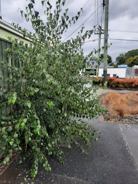

Reported here
 Overgrown Vegetation —
 This planted area has not been trimmed back like other ones in the street have. Also there are branches that have been dumped there
 Graffiti on a fence, building or structure —
 graffiti post
 Overgrown Vegetation —
 Deadly nightshade plants growing in and into the footpath
 Overgrown Vegetation —
 Overhanging tree needs cut back as obstructing path between burke st and fairfield ave
 Graffiti on a fence, building or structure —
 Graffiti on public walkway
 Graffiti on a fence, building or structure —
  Graffiti —
 Graffiti on the fence at the walkway between Burke St and Fairfield Ave
- General Request —
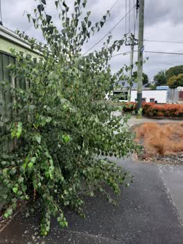 Roading/Streets —
 This tree is blocking the footpath
 Rubbish/Recycling —
 illegal dumping,window with frame broken glass in garden
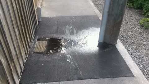
Water Supply —
Leaking water supply
Also reported on Fairfield Avenue
- 72 Fairfield Avenue — 47 reports
- 47 Fairfield Avenue — 40 reports
- 33 Fairfield Avenue — 19 reports
- 68B Fairfield Avenue — 14 reports
- 80 Fairfield Avenue — 11 reports
- 64 Fairfield Avenue — 11 reports
- 39 Fairfield Avenue — 11 reports
- 68A Fairfield Avenue — 10 reports
The street’s crash record
NZTA’s record names Fairfield Avenue in 7 crashes that hurt somebody since 2006 — 0 seriously hurt, nobody killed.
The green nearby
- Baxters Drain — 13 m to the edge
- Addington Cemetery — 67 m to the edge · Botanic · 2 ha
- Ruskin Reserve — 89 m to the edge
- Braddon Reserve — 219 m to the edge
- Disraeli Reserve — 253 m to the edge
Parks within half a kilometre, measured to the boundary — the council’s open data.
On the doorstep
- Everybody's Butchery — 269 m away · Butchers
- Richfields — 270 m away · Delis
- Resure — 296 m away · Insurance
- Creative Junk — 299 m away · Variety Store
Businesses within four hundred metres, measured at the pin — OpenStreetMap and the council directories.
The bus nearby
- Antigua St near Fairfield Ave — 246 m away · route 120
- Selwyn St near Fairfield Ave — 250 m away · route 60
The closest Metro stops, within four hundred and fifty metres.
The tracks through here
- Walk and bike track through Addington — 240 m to the line · walk · bike
- Walk and bike track through Addington — 254 m to the line · walk · bike
- Walk and bike track through Addington — 499 m to the line · walk · bike
- Walk and bike track through Addington — 499 m to the line · walk · bike
Tracks whose line passes within half a kilometre, measured to the line itself — the council’s open data.
The named ground
Named water within 500 m of this address, measured to the line or the edge; Named places within 1.5 km of this address; the council’s own structure register — bridges, boardwalks and steps standing nearby — the open map’s record.
The remembered names nearby
- What a Difference a Drain Makes! — 30 m away ·
What a difference a drain makes! / Push the lever and look down to your right into a repli
· 2000 - The Thistle, Reproduced Here From the Addington Cemetery — 73 m away ·
The Thistle, reproduced here from the Addington Cemetery, forms part of the Literary Stree
· 2008 - Baxters Drain plaque — 73 m away ·
(Decorative thistle carving – no text)
· 2008
Inscribed plaques within two hundred and fifty metres — the register’s pins, not surveyed spots. The whole roll is at /plaques.
Renting nearby
new bonds in Addington ran about $502 a week — $48 below the city median of $550 — the suburb page keeps the rent record →.
What was here — Addington Cemetery and Setting
162 m away · 410 Selwyn Street · located to ±130 m · the place’s own record →
On the register. Nothing researched here yet.
The civic layer
This ground votes in Spreydon ward — the Spreydon-Cashmere-Heathcote community board. Ward lines don’t always follow suburb lines; this one is measured at the pin, not the suburb’s centre.
What stood on this ground → · On the map → · From the air — the Crown’s aerials back to 1936; search the address on RetroLens →
Questions, answered briefly
11 council reports on record since November 2016 — most often overgrown vegetation (3), graffiti on a fence, building or structure (3), water supply (1).
Addington, Christchurch — on Fairfield Avenue.
The heritage register names a place at or beside it — Addington Cemetery and Setting.
Baxters Drain — 13 m to its edge.