280 Long Bay Road
1 council report since January 2017, 1 carrying a photograph. The street’s heaviest record is 490 Long Bay Road, 2 reports on file.
The green nearby
- Akaroa Heritage Park, you are in it · 1 ha
Parks within half a kilometre, measured to the boundary, the council’s open data. The whole roll is at /parks.
On the doorstep
- Akaroa Heritage park, 63 m away · Attractions
Businesses within four hundred metres, measured at the pin, OpenStreetMap and the council directories.
The named ground
Named places within 1.5 km of this address; the council’s own structure register, bridges, boardwalks and steps standing nearby, the open map’s record.
The remembered names nearby
- Set Me Right Read Me Well and I to Thee the Time Will Tell, 25 m away ·
SET ME RIGHT READ ME WELL AND I TO THEE THE TIME WILL TELL
· 2008 - With Memories of / Una & Jack Reid, 46 m away ·
With Memories of / Una & Jack Reid
· 2008 - In Loving Memory of Alvine Rosemary Robertson 1959–2003, 48 m away ·
IN LOVING MEMORY OF ALVINE ROSEMARY ROBERTSON 1959–2003
· 2008
Inscribed plaques within two hundred and fifty metres, the register’s pins, not surveyed spots. The whole roll is at /plaques.
What gets reported here
- Parks, 1
Photographed here 1 on record
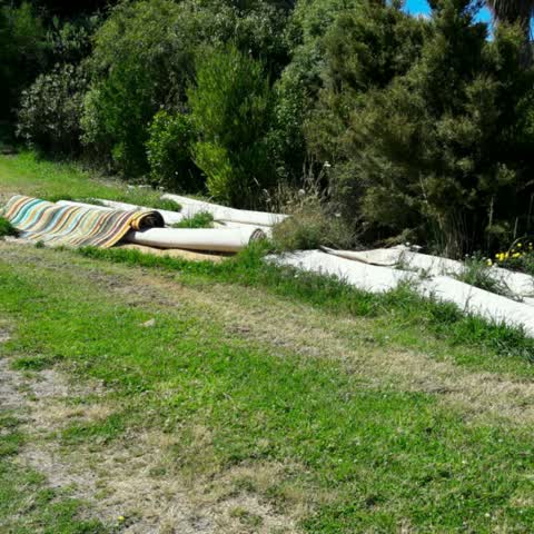
What’s on record
Parks, 31 Jan 2017
Rolls of carpet left on the woodills track side of the park where the park opens up to the clearing at the top
Elsewhere on Long Bay Road
- 490 Long Bay Road, 2 reports
- 632 Long Bay Road, 1 report
- 407 Long Bay Road, 1 report
- 2 Long Bay Road, 1 report
The street’s crash record
NZTA’s record names Long Bay Road in 7 crashes that hurt somebody since 2006, 5 seriously hurt, nobody killed.
The civic layer
This ground votes in Banks Peninsula ward, the Banks Peninsula community board is its local layer. Ward lines don’t always follow suburb lines; this one is measured at the pin, not the suburb’s centre. The whole roll is at /wards.
Long Bay Road, the whole record → · Everything about Akaroa → · What stood on this ground → · On the map → · From the air, RetroLens holds the Crown’s aerials back to 1936; search the address there →
Questions, answered briefly
1 council report on record since January 2017, most often parks (1).
Akaroa, Christchurch, on Long Bay Road.
Nothing on the heritage register at this exact spot, the record around this ground →
Akaroa Heritage Park, the address is inside it, 1 ha.