Water General57 Rue Lavaud
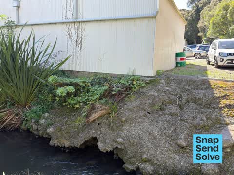
Land being cleared has turned up erosion and what looks to be an old stone retaining wall that has served its time. This is a urgent response required as land…
1,918 council reports since July 2015, the 65th busiest suburb in the city. 1,534 photographs on record. 640 people at the 2023 Census, 4 to the square kilometre across 154 km².
The record also holds 2023 Census snapshot· 1,534 photographs· 206 old photographs· 1 school· 35 parks· 8 civic facilities· 3 places of worship· 110 names on the map· the record drew water over 11% of the outline· inside the broad slope-instability overlay· the Ngāi Tahu schedule covers 31% of the outline· ecological sites over 1% of the outline· landscape schedules over 71% of the outline· setback strips over 4% of the outline· 49 SCIRT photographs filed on this ground· 62 remembered names on this ground· 37 drawn rules bind this ground· 1 parcels on the dangerous-work register· 18 parcels of made ground· 2 parcels with a cleanup on file· 151 council structures on the register· 18 recreation register records· 710 trees on the register· the plan’s word on this ground· 123 places on the heritage schedule· 1 epicentre inside the outline· 58 injury crashes· 94 recorded victimisations· 121 businesses· the council’s fix times· 40 documents· 5 mentions on the wire
Link-outs to the source’s own live pages, chch.live does not copy their live values or source text.
Rent: too few new bonds lodged here for Tenancy Services to publish a median this quarter, the last figure it released was about $475 a week, and it counts this under the “Akaroa” statistical area, close to this suburb’s outline, not exactly it.
Median and quartiles of weekly rents on new private bonds, by quarter. New bonds are fresh lodgements, not the whole rental stock; under five bonds the rent is withheld, and counts are randomly rounded. Source: Tenancy Services rental bond data: provisional while the bond system migrates.
The ground: the flood record drew water over 11% of it, the rest of the watch is drawn further down.
Day to day it holds 1 school, 35 parks, 8 civic facilities and 3 places of worship, each is counted further down.
Lately the record’s mostly roads & footpaths, 299 reports in the year to 13 October 2026, the newest 4 September 2026.
One for the quiz, Its busiest day on record was 30 September 2023, 11 reports in a single day.
About 633 people and 288 occupied private households in the “Akaroa” statistical area, grouped from 6 SA1 areas. This exact statistical-area match is close to this suburb’s outline, not exactly it.
Ethnicity is a multiple-response measure, so those percentages are not meant to add to 100%.
Stats NZ’s 2023 Census uses fixed random rounding to base 3. Unavailable or confidential cells are left out, not treated as zero. individuals · households · geography · CC BY 4.0.
Akaroa is a small town on Banks Peninsula in the Canterbury Region of the South Island of New Zealand, situated within a harbour of the same name. The name Akaroa is Kāi Tahu Māori for "Long Harbour", which would be spelled Whangaroa in standard Māori. The area was also named Port Louis-Philippe by French settlers after the reigning French king Louis Philippe I.
Placed by the record’s locality join or the name in its own title, a lead, not a claim each frame stood here.
Land being cleared has turned up erosion and what looks to be an old stone retaining wall that has served its time. This is a urgent response required as land…


Overhanging tree at the beginning of steep part of Woodills Road Akaroa . This tree seems to be getting lower and in danger of falling down on the road or a…

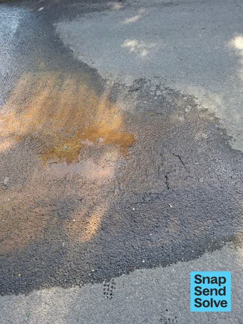
Water leak in previous watermain blow out location, maybe nothing by a consistent low level flow of clear water existing from the seashore bank at the same…


A lot of water on the ground at Akaroa rec ground outside kindy and cricket pavilion.



Cover broken and someone or animal may put foot or walking stick in and fall

The median council work order pinned in Akaroa took 13 days to resolve, the city-wide median is 3 days, so this ground runs slower than the city as a whole. The slowest tenth waited 4 months or longer. 146 tickets are open here now, the oldest was filed 12 August 2020.
Work orders, not the resident reports above, the council’s MyCouncilTicket stream, and one job can appear in both. A median counts only finished jobs; open ones are named as open, never averaged in. The ticket roll · the whole city’s fix times.
One sensitive site stands here, Akaroa Area School, and the Local Alcohol Policy restricts new off-licences within 50 m of it.
The council’s bylaw zones and the Local Alcohol Policy’s buffer list, read from the Regulatory open-data service. A ban rules drinking in public places; it says nothing about whether a premises may sell, that is the licence register’s job.
Zoned for Aidanfield Christian School · Christchurch Adventist School · Middleton Grange School · St Thomas of Canterbury College · Villa Maria College, the drawn zone is indicative; the Ministry’s written scheme is the legal boundary.
Decile and EQI describe the community a school draws from, not how well it teaches.
The first eight of 35, Parks and reserves in the council’s open data, a park lands in the suburb its centre falls inside. The whole roll is at /parks.
Libraries, halls, cemeteries and the rest in the council’s open data, a facility lands in the suburb its point or centre falls inside. The whole shelf is at /facilities.
Places of worship in the open map’s record, one lands in the suburb its building stands in. The whole roll is at /worship.
The flood record drew water over 11.0% of this outline, about 1,702 hectares, across 3 named events. A patch is one event’s observation, not a live hazard finding; the whole record is drawn at /floods.
No named slope-hazard band reaches this outline. The broad remaining-instability overlay covers 72% of it besides, the plan’s background watch over the hill country. Shares read from a sampled join; a management overlay, not a prediction. The whole watch is drawn at /slope.
1 parcel inside this outline sits on the hazardous-activities register, mostly vehicle refuelling, service and repair. A listing records the work, not a soil test; the whole register is drawn at /hazards.
The files record 18 parcels of made or characterised ground inside this outline, mostly sand, gravel, silt. A record is the file’s word on what was laid, not a fresh survey; the whole layer is drawn at /fill.
2 parcels inside this outline carry a cleanup on the file, 2 marked verified. A cleanup on the file is the register’s word, not a clearance; the whole register is drawn at /remediated.
The council’s structure register stands 151 assets on this ground, 80 sets of steps, 24 boardwalks, 15 shelters, 11 bridges, sited at Takapuneke Reserve, Garden Of Tane, Childrens Bay, Stanley Park. The register’s site names are its own labels for the ground an asset stands in; the layer is drawn at the map.
The recreation register keeps 18 records inside this outline, bookable surfaces for 3 cricket, 3 tennis, 3 netball, 3 pickleball. Seasons and surfaces are the register’s record, not this week’s draw; the layer is drawn at the map.
The register counts 710 living trees inside this outline, 113 veterans among them, 94 carrying a protection, mostly Ngaio, English Oak, Pohutukawa. The file remembers 77 trees felled here. A tree record is the register’s word on what stands or stood; the whole canopy is drawn at /trees.
The plan files 57% of this outline under Rural Banks Peninsula, the rest mostly Open Space Natural 11%, Papakainga Kainga Nohoanga 2%, 72% of the outline fell inside a mapped zone. A zone is a permission, not a description, the mix is read from a sampled join of the plan’s polygons; the whole district is drawn at /zones.
The plan’s heritage schedule protects 123 places by name in this suburb, 21 graded highly significant, Akaroa Lighthouse and Setting, Banks Peninsula War Memorial and Setting, Dwelling and Setting among them. A setting is the ground the item stands in, each files under the suburb holding its centroid; the whole schedule is at /heritage.
The plan’s schedule of sites significant to Ngāi Tahu covers 31% of this outline, about 4,809 hectares, ngā tūranga tūpuna, ngā wai, wāhi tapu/wāhi taonga. A silent-file precinct covers 3% of it besides, sensitive ground the plan flags without naming the sites. Shares read from a sampled join; a recognition overlay, not a catalogue. The whole schedule is drawn at /cultural.
The plan’s ecological schedules cover 1% of this outline, about 78 hectares across 1 scheduled site, 1% of it Schedule B, identified on private land but not yet protected. Shares read from a sampled join; a recognition overlay, not a survey. The whole ledger is drawn at /ecology.
The plan’s landscape schedules cover 71% of this outline, about 11,014 hectares across 39 scheduled areas, 27% of it outstanding, the plan’s strongest landscape standing, and 14% of it sits inside the coastal environment. 4 main ridgelines run through, the skyline itself is protected. Shares read from a sampled join; a protection overlay, not a ranking of views. The kept view is drawn at /landscape.
The plan’s water-margin layers cross this outline, 336 classified reaches, the plan calling Grehan Stream and Balguerie Stream by name, 4% of it inside the setback strips, the widest holding 20 m off the bank. The margin is the plan’s drawing, not a survey of the bank; the reaches, strips and held edges are mapped at /water-margin.
The plan’s allowed shape holds this outline, 8 hill density lines hold the high ground low, Akaroa’s heritage character area covers the town. The shape is the plan’s permission, not a survey of what stands; the allowed shape is drawn at /density.
The rebuild’s cameras filed 49 photographs on this ground, 2011–2012, stormwater work mostly. Each frame is a receipt the dig left behind, a work log, not a survey of what stands now; the whole record is drawn at /rebuild.
The remembered names stand on this ground, 62 inscribed plaques, Garden Of Tane, Akaroa War Memorial, Akaroa Recreation Ground among the grounds. The plaque is the register’s pin, not a surveyed spot; the whole roll is kept at /plaques.
The rulebook binds this ground, 37 drawn instruments, 27 of them dog rules, 1 alcohol ban, 8 camping zones, a certified self-contained van can stay the night at Akaroa Freedom Camping Area and Robinson’s Bay Restricted Area and Takamatua Restricted Area; the other 3 zones ban it outright, 1 bottle-store buffer; the outline sits inside the takiwā of Te Runanga o Koukourarata and Te Runanga o Onuku. The bylaw is the instrument, this the map of it, the whole rulebook is drawn at /rules.
GeoNet’s catalogue puts 1 magnitude-3+ epicentre inside this outline since the sequence opened, the biggest a M3.0 in 2011. An epicentre is where the instruments placed the break, not a measure of the shaking here; the whole catalogue is counted at /sequence, the live record is /quakes, and the story in plain language is the earthquakes explainer.
The named waterways, bays, headlands, monuments, summits and old sites OpenStreetMap puts inside this outline, a pin is the mapper’s own; a waterway belongs to every suburb it crosses. Every roll, counted: /geography.
58 crashes that hurt somebody on record inside Akaroa's outline, 2 people killed, 22 seriously hurt.
The corner that keeps appearing: Onuku Road at Stanley Place, 4 injury crashes, 1 fatal.
94 victimisations on the Police record inside Akaroa’s outline, September 2022–August 2026, mostly theft, about 37 a year per 1,000 residents. Up 71% on the year before. Reported is not all, how much never reaches the record depends on the offence.
121 premises in Akaroa across 38 kinds, from OpenStreetMap, the council’s licensed-premises register and its 2024 Find Christchurch directory. Each kind below opens at this suburb’s shelf.
Among them, the ones the record says most about:
What the archive’s sources say about Akaroa, titled for it, turned up by a search for one of its places, or carrying its name in the text. These are leads and citations: the originals live at the provider, linked from each row.
…oad 141 chains and numbered 60 on the chief surveyor map no 61 daniel waikins 50 acres in akaroa harbour on the french creek frontage on the harbour and numbered 61 on the chief surveyor map no 62 b l…Lyttelton Times · Papers Past · National Library of New Zealand · · text held
…ns and numbered 99 on the chief surveyor map no 100 j dick en 100 acres in the harbour of akaroa the part commonly known as the french farm sea frontage and numbered 100 on the chief surveyor map no 1…Lyttelton Times · Papers Past · National Library of New Zealand · · text held
…espect we are anxious to call the attention of all i masters of crafts sailing to or from akaroa to 1 no 13 of the harbor regulations which we i publish this week under the head post office and mails…Lyttelton Times · Papers Past · National Library of New Zealand · · text held
akaroa to be let on lease for building on several very desirable quarter-acre town sections on the properties…Lyttelton Times · Papers Past · National Library of New Zealand · · text held
com missioner of crown lands office akaroa february 2 1852 notice hp he commissioner under the ordinance of council session 1 no 2 purposes on tue…Lyttelton Times · Papers Past · National Library of New Zealand · · text held
…application at the office of mr richard wormald solicitor london street lyttelton land at akaroa two and a half acres of building land for sale in small allotments in a central part of the town of aka…Lyttelton Times · Papers Past · National Library of New Zealand · · text held
…be directed to call public meetings of all the inhabitants at christchurch lyttelton and akaroa for the purpose of effecting such an acquisition the third resolution was moved by captain westenra sec…Lyttelton Times · Papers Past · National Library of New Zealand · · text held
…application at the office of mr richard wormald solicitor loudon street lyttelton land at akaroa npwo and a half acres of building j land for sale in small allotments in a central part of the town of…Lyttelton Times · Papers Past · National Library of New Zealand · · text held
…application at the oilioe of mr richard wormald solicitor london street lyttelton land at akaroa two and a half acres of building land for sale in small allotments in a central part of the town of aka…Lyttelton Times · Papers Past · National Library of New Zealand · · text held
…omprised in the town of christchurch district in the town of lyttelton district or in the akaroa district 3 the town of lyttelton distbict comprises the site of the town of lyttelton as shown in the p…Lyttelton Times · Papers Past · National Library of New Zealand · · text held
The rest are a search away, the whole shelf, for the name →
Compare Akaroa with Wainui · Duvauchelle · Le Bons Bay · Okains Bay · Pigeon Bay · Little River, same record, side by side.
Akaroa is a small town on Banks Peninsula in the Canterbury Region of the South Island of New Zealand, situated within a harbour of the same name. The public record holds 1,918 council reports for it, the first filed in July 2015.
640 people at the 2023 Census, 4 per square kilometre across 154 km².
About 633 people and 288 occupied private households: grouped from Stats NZ SA1 areas through this site’s suburb join. Indicative, not a LIM.
1,918 reports on record, most often roads & footpaths (700), water & drains (572), trees & parks (402). 299 of them in the year to 13 October 2026.
58 injury crashes on the police record inside the suburb’s outline, 2 people killed, 22 seriously hurt. The suburb’s crashes, mapped →
GeoNet’s catalogue puts 1 magnitude-3+ epicentre inside the suburb’s mapped outline since the September 2010 mainshock, the biggest a M3.0 in 2011. An epicentre is where the instruments placed the break, not a measure of the shaking felt here. The whole sequence, counted → · The story, in plain language →
Every suburb in Christchurch → · Its decade, charted → · the whole A–Z →
Work orders, not the resident reports above, the council’s MyCouncilTicket stream, and one job can appear in both. A median counts only finished jobs; open ones are named as open, never averaged in. The ticket roll · the whole city’s fix times.
The council’s bylaw zones and the Local Alcohol Policy’s buffer list, read from the Regulatory open-data service. A ban rules drinking in public places; it says nothing about whether a premises may sell, that is the licence register’s job.
Ministry of Education directory, the final decile and the current Equity Index describe the community a school draws from, not how well it teaches. Zones are indicative; the written enrolment scheme rules.
Parks and reserves in the council’s open data, the park lands in the suburb its centre falls inside; one that straddles the line keeps its own address.
Libraries, halls, cemeteries and the rest in the council’s open data, a facility lands in the suburb its point or centre falls inside.
Places of worship in the open map’s record, one lands in the suburb its building stands in. The whole roll is at /worship.
Marae in the region’s roll, a marae stands where it stands; the join names the suburb the roll files it under. The whole roll is at /maraes.
Walking, biking, horse and off-road tracks in the council’s open data, a line belongs to every suburb it passes through.
OpenStreetMap’s own record, inside this outline, a pin is the mapper’s; a waterway belongs to every suburb it crosses. Every roll, counted: /geography.
Heritage places the council’s district plan or Heritage New Zealand list inside this suburb, each with what is known about it and the document it is known from.
The register’s era records for places in this suburb, what stood on the ground, and when.
Each of these is a decade of reports, the heritage places on the register, what is known about them, and the documents behind it, everything the archive holds about the part of the city it names.