38 Kingfisher Road
3 council reports since May 2025, 3 carrying a photograph. The most-reported address on Kingfisher Road.
The green nearby
- Kingfisher Reserve, 19 m to the edge
- Kotare Reserve, 236 m to the edge
Parks within half a kilometre, measured to the boundary, the council’s open data. The whole roll is at /parks.
The named ground
Named places within 1.5 km of this address; the council’s own structure register, bridges, boardwalks and steps standing nearby, the open map’s record.
What gets reported here
- Flooding, 2
- Water Leak, 1
Photographed here 3 on record
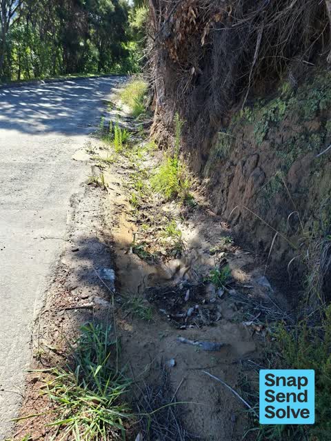


What’s on record
 Flooding, 19 Feb 2026
 drain blocked after heavy rain. Needs regular clearing please.
 Water Leak, 9 Jan 2026
 Water is flowing, on the road near the entrance to 33 Kingfisher Road, Takamatua
 Flooding, 18 May 2025
 During recent rain event, water was pouring down our driveway and across our section. A temporary block wall diverted it successfully into d
Elsewhere on Kingfisher Road
- 37 Kingfisher Road, 3 reports
- 6C Kingfisher Road, 2 reports
- 6 Kingfisher Road, 2 reports
- 5B Kingfisher Road, 2 reports
- 5A Kingfisher Road, 2 reports
- 33 Kingfisher Road, 2 reports
- 29 Kingfisher Road, 2 reports
- 5C Kingfisher Road, 1 report
The civic layer
This ground votes in Banks Peninsula ward, the Banks Peninsula community board is its local layer. Ward lines don’t always follow suburb lines; this one is measured at the pin, not the suburb’s centre. The whole roll is at /wards.
Kingfisher Road, the whole record → · Everything about Akaroa → · What stood on this ground → · On the map → · From the air, RetroLens holds the Crown’s aerials back to 1936; search the address there →
Questions, answered briefly
3 council reports on record since May 2025, most often flooding (2), water leak (1).
Akaroa, Christchurch, on Kingfisher Road.
Nothing on the heritage register at this exact spot, the record around this ground →
Kingfisher Reserve, 19 m to its edge.