4 Smith Street
2 council reports since February 2021, 2 carrying a photograph. The street’s heaviest record is 21 Smith Street, 3 reports on file.
The green nearby
- Akaroa Beach, 50 m to the edge · 1 ha
- Cenotaph War Memorial, 120 m to the edge · Botanic
- Stanley Park, 160 m to the edge · 7 ha
- Rue Balguerie Reserve, 172 m to the edge
- Rue Balguerie Playground, 182 m to the edge · Botanic · playground, 4 pieces
Parks within half a kilometre, measured to the boundary, the council’s open data. The whole roll is at /parks.
The civic shelf nearby
- Akaroa Library, 439 m away · Library
- Akaroa Collection Point, 465 m away · Transfer station
Libraries, halls and the rest within half a kilometre, the council’s open data.
On the doorstep
- Garthowen Bed and Breakfast, 29 m away · B&Bs
- Tini Bar & Eatery, 85 m away · Restaurants
- Maison de la Mer, 95 m away · B&Bs
- Tīni Gin Bar & Eatery, 163 m away · Bars & pubs
Businesses within four hundred metres, measured at the pin, OpenStreetMap and the council directories.
The named ground
Named water within 500 m of this address, measured to the line or the edge; Named places within 1.5 km of this address; the council’s own structure register, bridges, boardwalks and steps standing nearby, the open map’s record.
The remembered names nearby
- Whaling Tripot / Used by / Capt Hempleman / Peraki / 1836, 104 m away ·
WHALING TRIPOT / USED BY / CAPT HEMPLEMAN / PERAKI / 1836
- In Loving Memory of / Peter and Jan Sisson, 118 m away ·
In Loving Memory of / Peter and Jan Sisson
- Eileen Lott / Memorial Ramp, 122 m away ·
EILEEN LOTT / MEMORIAL RAMP / (lower lines illegible)
Inscribed plaques within two hundred and fifty metres, the register’s pins, not surveyed spots. The whole roll is at /plaques.
What gets reported here
Photographed here 2 on record

What’s on record
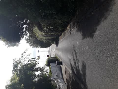
 Overgrown Vegetation, 10 Jan 2025
 The trees on council land, up the left hand side of Smith Street (going up hill) are too tall. They need to be trimmed at the top. They are
 Roading/Streets, 21 Feb 2021
 Again same issue on Smith Street overgrowth restricts vehicle use
Elsewhere on Smith Street
- 21 Smith Street, 3 reports
- 7 Smith Street, 1 report
- 3 Smith Street, 1 report
The civic layer
This ground votes in Banks Peninsula ward, the Banks Peninsula community board is its local layer. Ward lines don’t always follow suburb lines; this one is measured at the pin, not the suburb’s centre. The whole roll is at /wards.
Smith Street, the whole record → · Everything about Akaroa → · What stood on this ground → · On the map → · From the air, RetroLens holds the Crown’s aerials back to 1936; search the address there →
Questions, answered briefly
2 council reports on record since February 2021, most often roading/streets (1), overgrown vegetation (1).
Akaroa, Christchurch, on Smith Street.
Nothing on the heritage register at this exact spot, the record around this ground →
Akaroa Beach, 50 m to its edge, 1 ha.