4I 4I
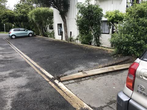
1 council report since November 2020, 1 carrying a photograph.
The green nearby
- Britomart Reserve, 52 m to the edge
- Walnut Place Reserve, 201 m to the edge
- Stanley Park, 255 m to the edge · 7 ha
- Akaroa Beach, 270 m to the edge · 1 ha
- Garden Of Tane, 284 m to the edge · Botanic · 6 ha · playground, 7 pieces
Parks within half a kilometre, measured to the boundary, the council’s open data. The whole roll is at /parks.
The civic shelf nearby
- Akaroa Library, 112 m away · Library
- Akaroa Anglican And Dissenters Cemetery, 467 m away · Cemetery
Libraries, halls and the rest within half a kilometre, the council’s open data.
On the doorstep
- Bruce Waterfront Apartments, 24 m away · Hotels
- Akaroa Waterfront Accommodation, 33 m away · Motels
- The Akaroa Cooking School, 33 m away · Restaurants
- Akaroa Village Inn, 44 m away · Hotels
Businesses within four hundred metres, measured at the pin, OpenStreetMap and the council directories.
The named ground
Named water within 500 m of this address, measured to the line or the edge; Named places within 1.5 km of this address; the council’s own structure register, bridges, boardwalks and steps standing nearby, the open map’s record.
The remembered names nearby
- In Loving Memory of / Rod Steel / 1927 - 2004, 68 m away ·
In loving memory of / ROD STEEL / 1927 - 2004
- Commander Frank Arthur Worsley Dso and Bar, OBE, Rnr, 69 m away ·
COMMANDER FRANK ARTHUR WORSLEY DSO AND BAR, OBE, RNR. BORN AND RAISED IN AKAROA 1872. DIED
· 2008 - Charles Edward Cooke / Eddie 1947-2023, 73 m away ·
Charles Edward Cooke / Eddie 1947-2023 / Where sea meets the sky, he found his peace. Dail
· 2025
Inscribed plaques within two hundred and fifty metres, the register’s pins, not surveyed spots. The whole roll is at /plaques.
What gets reported here
Photographed here 1 on record
What’s on record
 Roading/Streets, 26 Nov 2020
 The car park edging board adjacent to footpath in Aubrey Street has neen damaged - resulting in a loose board with nails lying adhacent to t
The civic layer
This ground votes in Banks Peninsula ward, the Banks Peninsula community board is its local layer. Ward lines don’t always follow suburb lines; this one is measured at the pin, not the suburb’s centre. The whole roll is at /wards.
Everything about Akaroa → · What stood on this ground → · On the map → · From the air, RetroLens holds the Crown’s aerials back to 1936; search the address there →
Questions, answered briefly
1 council report on record since November 2020, most often roading/streets (1).
Akaroa, Christchurch, on I.
Nothing on the heritage register at this exact spot, the record around this ground →
Britomart Reserve, 52 m to its edge.